
Admiralty charts are nautical charts issued by the United Kingdom Hydrographic Office (UKHO) and subject to Crown Copyright. Over 3,500 Standard Nautical...
27 KB (3,133 words) - 15:36, 22 September 2024
Look up admiralty in Wiktionary, the free dictionary. Admiralty most often refers to: Admiralty, Hong Kong Admiralty (United Kingdom), military department...
3 KB (435 words) - 04:10, 28 October 2023

as Digitrace, Voyager, or ChartCo, to correct British Admiralty charts as well as NOAA charts. These systems provide only vessel relevant corrections...
17 KB (2,284 words) - 19:32, 18 September 2024

airship-submarine, the Flying-Fish is hidden in Hurd's Deep between adventures. Admiralty Chart No 2649 English Channel Western Portion of 1955 shows munitions have...
9 KB (892 words) - 17:25, 28 September 2023
United Kingdom Hydrographic Office (redirect from Admiralty number)
produces Admiralty charts, providing SOLAS-compliant charts, publications and digital services for ships trading internationally. The Admiralty's first Hydrographer...
21 KB (2,087 words) - 18:49, 2 October 2024

drawing the first accurate maritime charts of this complicated Indian Ocean atoll group. These Admiralty charts were printed as three separate large...
37 KB (5,448 words) - 08:47, 27 September 2024
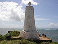
Kingdom Admiralty chart, based on Owen's 1823 version but including his own updates, records the padrão as 'Vasco da Gama's Pillar'. The same chart notes...
12 KB (1,435 words) - 05:44, 19 June 2024

measuring shorelines. His results were compiled in new charts.[citation needed] The Admiralty gave Beaufort his first ship command, HMS Woolwich. He sailed...
22 KB (2,392 words) - 04:01, 14 October 2024

The Admiralty was a department of the Government of the United Kingdom responsible for the command of the Royal Navy until 1964, historically under its...
27 KB (3,092 words) - 11:39, 9 September 2024

Beaufort's Dyke, highlighted in blue, on a 1969 Admiralty chart...
8 KB (786 words) - 08:18, 13 October 2024

almost disappeared by the end of 17th century. An 1823 United Kingdom Admiralty chart of 'Melinda' declared that at that time there were 'no vestiges of...
22 KB (1,956 words) - 19:10, 16 October 2024

Knot (unit) (redirect from Admiralty Knot)
miles on a chart can easily be measured by using dividers and the latitude scales on the sides of the chart. Recent British Admiralty charts have a latitude...
10 KB (1,184 words) - 19:58, 26 September 2024

late-19th-century maps, including an 1881 German map and 1895 British Admiralty chart. After returning from a voyage in the Pacific, the Velocity's master...
16 KB (1,822 words) - 22:12, 7 October 2024

Palk Strait, northern Sri Lanka. This island is named as Delft in the Admiralty Chart unlike the other islands, whose names are Tamil. The island's area...
7 KB (523 words) - 03:38, 15 June 2024

Ltd. Admiralty Chart 2484 - River Thames Hole Haven to London Bridge (2013) Admiralty Chart 1185 - River Thames Sea Reach (2017) Admiralty Chart 1183...
30 KB (2,658 words) - 17:33, 30 July 2024
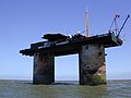
by a diplomat from the German embassy in London. According to the Admiralty chart the fort's location is at 51°53.71′N 1°28.83′E. The structure is marked...
9 KB (1,037 words) - 19:19, 25 July 2024

was formally set as The Narrows by Henry Kellett during the British Admiralty chart reorganization of 1847. Phillips, James W. (1971). Washington State...
2 KB (129 words) - 04:25, 27 July 2022

ISBN 0-671-02811-1. WashingtonEdmund George Irving (1966). Admiralty Chart No 2693 Approaches to Harwich. London: Admiralty. "WHR 053 - Redgate Hard -". Suffolk Heritage...
12 KB (1,216 words) - 12:43, 6 September 2024

very inaccessible island appears, though unnamed, on Ambrose Cowley's 1684 chart. It is important as the location of multidecade finch population studies...
112 KB (12,514 words) - 00:33, 13 October 2024
Rasdhoo (Dhivehi: ރަސްދޫ) (Rasdu in the Admiralty Chart) is an inhabited island of the Maldives. It is also the capital of the Alif Alif Atoll administrative...
4 KB (225 words) - 07:10, 9 April 2024

Notice to Mariners 164/1122/1902." While it is absent from the 1859 Admiralty Chart, it is unclear if the 1902 sighting is the very first one by the Ernest‑Legouvé...
7 KB (990 words) - 07:33, 4 June 2024
in June, and while the ringleaders were punished, much was done by the Admiralty to improve pay and conditions for the seamen. In 1804, Jonathan Martin...
6 KB (808 words) - 16:22, 12 November 2023
Kadhdhoo or Kaddhoo, Kahdhoo (according to the Admiralty Charts) (Dhivehi: ކައްދޫ އެއަރޕޯޓް) is one of the inhabited islands of Haddummati Atoll, administrative...
6 KB (177 words) - 09:43, 29 February 2024

Carlos Water 23 May 1982 Admiralty Chart 2582 – Plans in Falkland Sound (Map). 1:25000. Hydrographic Office. 2009. Admiralty Chart 2558 – Falkland Sound...
4 KB (459 words) - 10:05, 28 November 2023

Imperial Admiralty Staff, Admiralstab Admiralty of Amsterdam Admiralty of Friesland Admiralty of the Noorderkwartier (also called the "Admiralty of West-Friesland")...
1 KB (164 words) - 20:52, 31 December 2021

in the Maldives. 1. Alifushi and Etthingili (Powell Islands in the Admiralty Chart) stand on a detached reef of their own with very deep waters (no sounding)...
9 KB (903 words) - 20:39, 26 August 2024

1855 has the name "Otkiawik", which was later misprinted on a British Admiralty chart as "Otkiovik." The former name Barrow was derived from Point Barrow...
67 KB (6,427 words) - 19:11, 25 September 2024

Navigator (section Nautical charts)
issued by the Admiralty. When corrections are received all charts are corrected in the ship's folio and recorded in NP133A (Admiralty Chart Correction Log...
14 KB (1,827 words) - 02:03, 27 March 2024

November 2020. Retrieved 12 November 2020. Ritchie, G.S. (1967). The Admiralty Chart. London: Hollis & Carter. pp. 317–319. Richards, G.H. (1869). "Suez...
127 KB (14,126 words) - 23:28, 2 October 2024
tide, above the sea water level at the lowest astronomical tide. On admiralty charts a drying height is distinguished from a depth by being underlined....
431 bytes (47 words) - 17:39, 13 October 2021