
Bathymetry (/bəˈθɪmətri/; from Ancient Greek βαθύς (bathús) 'deep' and μέτρον (métron) 'measure') is the study of underwater depth of ocean floors (seabed...
27 KB (3,776 words) - 14:08, 30 June 2024

Lidar (redirect from Airborne laser bathymetry)
frequency doubled solid-state IR laser output is the standard for airborne bathymetry. This light can penetrate water but pulse strength attenuates exponentially...
130 KB (14,772 words) - 00:21, 24 September 2024

Satellite-derived bathymetry (SDB) is the calculation of shallow water depth from active or passive satellite imaging sensors. The technology requires...
6 KB (605 words) - 06:19, 2 October 2024

Challenger Deep (section Surveys and bathymetry)
isobath. Both the western and eastern basins have recorded depths (by sonar bathymetry) in excess of 10,920 m (35,827 ft), while the center basin is slightly...
174 KB (19,920 words) - 13:05, 8 October 2024

Lake Huron (category Articles using infobox body of water without alt bathymetry)
Huron Michigan lighthouses National Geophysical Data Center (1999). "Bathymetry of Lake Erie and Lake Saint Clair". National Oceanographic and Atmospheric...
33 KB (3,357 words) - 13:21, 23 August 2024

bathymetric chart is a type of isarithmic map that depicts the submerged bathymetry and physiographic features of ocean and sea bottoms. Their primary purpose...
9 KB (1,929 words) - 14:07, 25 May 2024

measurement of altitude is called altimetry, which is related to the term bathymetry, the measurement of depth under water. Altitude can be determined based...
6 KB (731 words) - 10:15, 4 October 2024
Diamantina Fracture Zone (section Bathymetry)
which are believed to be new species. The first high-resolution multibeam bathymetry of the central DFZ was collected between June 2014 and June 2016, for...
9 KB (1,014 words) - 03:34, 28 August 2024

False Bay (redirect from Bathymetry of False Bay)
Bellows Rock and a lesser one somewhat closer inshore at Anvil Rock. The bathymetry of False Bay differs in character from the west side of the Cape Peninsula...
120 KB (18,493 words) - 13:08, 10 September 2024

Sherman; MacLeod, Christopher; Taylor, Brian; Goodliffe, Andrew (2000). "Bathymetry of the Tonga Trench and Forearc: A Map Series". Marine Geophysical Researches...
267 KB (22,220 words) - 23:53, 7 October 2024
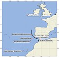
over the Camarinal Sill. The barotropic tidal currents interact with its bathymetry to produce a remarkable internal tide that in turn gives rise to dissipation...
16 KB (1,987 words) - 12:42, 27 August 2024

MR1 mapping system. This mapping system has the ability to record both bathymetry and sidescan data at the same time. The two vessels that this system was...
11 KB (1,008 words) - 08:49, 22 August 2024

and the global oceanic circulation, as well as the global climate. The bathymetry of the Drake Passage plays an important role in the global mixing of oceanic...
24 KB (2,633 words) - 19:18, 9 September 2024

Pfirman, Stephanie; Schenke, Hans Werner; Reil, Wolfgang (1990-08-01). "Bathymetry of Molloy Deep: Fram Strait between Svalbard and Greenland". Mar. Geophys...
9 KB (865 words) - 15:39, 4 August 2024

Great Lakes (category Articles using infobox body of water without alt bathymetry)
2010. From left to right: Lake Superior, Michigan, Huron, Erie, Ontario Bathymetry map of the Great Lakes Location Eastern North America Coordinates 45°N...
115 KB (12,010 words) - 09:31, 29 September 2024

Lake Victoria (category Articles using infobox body of water without image bathymetry)
Anthony Munyaho; Noah, Krach; Sarah, Glaser (17 May 2018). "Bathymetry TIFF, Lake Victoria Bathymetry, raster, 2017, V7" (Data Set). Harvard Dataverse. doi:10...
73 KB (8,069 words) - 04:31, 2 October 2024
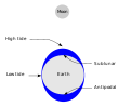
Tide (section Bathymetry)
systems of the oceans, and the shape of the coastline and near-shore bathymetry (see Timing). They are however only predictions, the actual time and height...
109 KB (13,080 words) - 19:04, 6 October 2024
Molloy Deep (category Articles using infobox body of water without image bathymetry)
earlier technology with less precise bathymetric methods. "Fram Strait Bathymetry". Alfred Wegener Institute for Polar- and Marine Research. Archived from...
13 KB (1,205 words) - 10:53, 29 July 2024

Bering Strait (category Articles using infobox body of water without alt bathymetry)
The Bering Strait (Russian: Берингов пролив, romanized: Beringov proliv) is a strait between the Pacific and Arctic oceans, separating the Chukchi Peninsula...
20 KB (2,116 words) - 18:13, 11 September 2024

Lake Michigan (category Articles using infobox body of water without alt bathymetry)
Geophysical Data Center Archived April 3, 2015, at the Wayback Machine, 1996. Bathymetry of Lake Michigan. National Geophysical Data Center, NOAA. doi:10.7289/V5B85627...
56 KB (5,305 words) - 17:16, 19 September 2024

samples. The Simrad EM300 multibeam side-scanning sonar system collected bathymetry and backscatter data. The Hawaiʻi hotspot has been imaged through seismic...
68 KB (7,845 words) - 22:03, 28 September 2024

NOAA Bathymetry Image of Puerto Rico (2020)...
254 KB (25,070 words) - 23:46, 6 October 2024

Atlantic Ocean (category Articles using infobox body of water without image bathymetry)
Marmara – 11,350 km2 Wadden Sea – 10,000 km2 Archipelago Sea – 8,300 km2 The bathymetry of the Atlantic is dominated by a submarine mountain range called the...
116 KB (12,537 words) - 02:29, 8 October 2024

internal structure of Earth is based on observations of topography and bathymetry, observations of rock in outcrop, samples brought to the surface from...
33 KB (3,154 words) - 12:41, 6 October 2024

the islands and possibly the Western coast of ancient North America. "Bathymetry image of the Hawaiian archipelago". United States Geological Survey (USGS)...
3 KB (330 words) - 14:18, 16 April 2023

Nepheloid layer (section Bathymetry)
Nepheloid layers can impact the accuracy of instruments when measuring bathymetry as well as affect the types of marine life in an area. There are several...
7 KB (906 words) - 20:48, 13 August 2023

Black Sea (category Articles using infobox body of water without alt bathymetry)
Еиқәа (Abkhaz) The location of the Black Sea Map of the Black Sea with bathymetry and surrounding relief Location Eastern Europe and West Asia Coordinates...
117 KB (11,732 words) - 23:15, 10 September 2024

Bénard et al. 2010, Introduction, pp. 1–2 NOAA Bathymetry Viewer https://maps.ngdc.noaa.gov/viewers/bathymetry/ Bénard et al. 2010, Geological and plate boundary...
23 KB (2,420 words) - 19:46, 9 August 2024

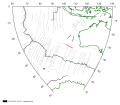
Bathymetry of the Palk Strait, showing water depth in metres...
30 KB (3,276 words) - 16:27, 27 September 2024
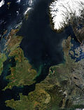
North Sea (category Articles using infobox body of water without image bathymetry)
Map all coordinates in "Geography of the North Sea" using OpenStreetMap Download coordinates as: KML GPX (all coordinates) GPX (primary coordinates) GPX...
136 KB (12,101 words) - 18:00, 30 September 2024