
The Calcasieu River (/ˈkælkəˌʃuː/ KAL-kə-shoo; French: Rivière Calcasieu) is a river on the Gulf Coast in southwestern Louisiana. Approximately 200 miles...
8 KB (631 words) - 17:47, 6 August 2024
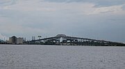
The Calcasieu River Bridge, officially named the Louisiana Memorial World War II Bridge in June 1951 is an arched cantilever, rivet-connected Warren through...
24 KB (2,971 words) - 20:54, 18 August 2024

Calcasieu Parish (/ˈkælkəˌʃuː/; French: Paroisse de Calcasieu) is a parish located on the southwestern border of the U.S. state of Louisiana. As of the...
50 KB (3,862 words) - 00:52, 11 September 2024

Lake Charles (Louisiana) (category Calcasieu River)
located on the Calcasieu River in Southwest Louisiana, United States, situated almost entirely within the Lake Charles city limits. The Calcasieu Ship Channel...
6 KB (525 words) - 17:37, 30 December 2023

Lake Charles, Louisiana (category Cities in Calcasieu Parish, Louisiana)
and the parish seat of Calcasieu Parish, located on Lake Charles, Prien Lake, and the Calcasieu River. Founded in 1861 in Calcasieu Parish, it is a major...
66 KB (5,732 words) - 01:12, 17 September 2024

Louisiana. The lake is the natural outlet of the Calcasieu River. Commercial traffic uses the Calcasieu Ship Channel that runs down the west side of lake...
4 KB (229 words) - 04:41, 22 July 2024

what is current-day Lake Charles. The area on the east side of the Calcasieu River was defined as the southern part of the "Neutral Ground" until ratification...
11 KB (1,363 words) - 01:33, 15 September 2024
Look up Calcasieu or Calcasieu Parish in Wiktionary, the free dictionary. Calcasieu may refer to several things, all located in the U.S. state of Louisiana:...
324 bytes (82 words) - 22:38, 18 June 2024
The Gulf Intracoastal Waterway (GIWW), from the Sabine River (Louisiana) to the Calcasieu River, was built between 1913 and 1914 with a width of 40 feet...
7 KB (718 words) - 22:02, 1 September 2024

Neutral Ground (Louisiana) (category Calcasieu River)
specified. The Arroyo Hondo and (unconnected) Calcasieu River were the eastern boundary, with the Sabine River serving as the western boundary. The southern...
12 KB (1,332 words) - 03:23, 12 June 2024

rivers and waterways. They include: Apalachicola River Arroyo Colorado Atchafalaya River Bayou Lafourche Bayou Terrebonne Calcasieu River Calcasieu Ship...
8 KB (659 words) - 05:18, 3 August 2024
Channel Calcasieu River West Fork Calcasieu River Houston River Ouiski Chitto Creek Sabine River Old River Bayou Anacoco Abita River Amite River Antoine...
8 KB (525 words) - 17:28, 25 July 2024

Adams–Onís Treaty (category Red River of the South)
the Calcasieu River and the Sabine River encompassed Los Adaes, the first capital of Spanish Texas. The region between the Calcasieu and Sabine rivers became...
46 KB (5,940 words) - 21:33, 24 August 2024

and west-central Louisiana, an area bounded by the Sabine River to the west, the Calcasieu River to the east, and by the city of Shreveport to the north...
17 KB (1,744 words) - 07:18, 3 July 2024

Prien Lake (category Bodies of water of Calcasieu Parish, Louisiana)
northeast. Prien Lake was historically located along the Calcasieu River. Construction of the Calcasieu Ship Channel was completed in 1941, and included the...
4 KB (326 words) - 19:21, 19 March 2024

The area between the Calcasieu River (at the time known to the Spanish as the Arroyo Hondo) on the east and the Sabine River on the west became a hotbed...
26 KB (2,472 words) - 11:43, 10 May 2024

as the Rio Hondo (now known as the Calcasieu river); however the land between the Rio Hondo and the Sabine river was in some dispute as the French were...
19 KB (1,506 words) - 00:51, 11 September 2024

166' from the road to the low water level in the river" (Tweet) – via Twitter. "Bridge over the river Green – Black Diamond History". blackdiamondhistory...
37 KB (1,170 words) - 21:16, 3 August 2024
Houston River begins at the crossing of LA 12, northeast of Starks, at the mouth of Bear Head creek in Calcasieu Parish, Louisiana, and terminates at the...
5 KB (336 words) - 22:17, 12 April 2024
Israel LaFleur Bridge (redirect from I-210 Calcasieu River High Bridge)
210 (Lake Charles Loop; a highway expansion that travels over the Calcasieu River, south of Lake Charles, and back up to Interstate 10). It is named...
2 KB (169 words) - 08:55, 29 May 2024
1806 to 1821 that was primarily bound on the east by the Calcasieu River and the Sabine River on the west. Most families ancestral to the Louisiana Redbones...
16 KB (2,007 words) - 07:05, 15 August 2024

USS Orleck (category Museums in Calcasieu Parish, Louisiana)
museum ship. The Orleck Foundation then decided to move the ship to the Calcasieu River in Lake Charles, Louisiana. On 26 March 2022, she arrived in Jacksonville...
13 KB (1,132 words) - 21:31, 14 July 2024

L'Auberge Casino Resort Lake Charles (category Calcasieu River)
Louisiana, the casino is built on a floating structure located on the Calcasieu River. "Archived copy" (PDF). Archived from the original (PDF) on 2012-04-12...
6 KB (411 words) - 18:44, 7 September 2024

Acadiana (category Geography of Calcasieu Parish, Louisiana)
wetlands increase in frequency in and around the Calcasieu River, Atchafalaya Basin, and the Mississippi River Delta. The area is cultivated with fields of...
38 KB (3,848 words) - 16:38, 5 September 2024
Whiskey Chitto Creek (category Rivers of Louisiana)
tributary to the Calcasieu River and is located between present-day Mittie and Reeves, Louisiana. Whiskey Chitto Creek is part of the Calcasieu River Basin. The...
3 KB (391 words) - 10:38, 25 September 2023
to Calcasieu Pass at the mouth of the Calcasieu River in southwestern Louisiana. She arrived there on 24 April and entered the mouth of the river in company...
4 KB (317 words) - 18:25, 2 September 2022
by Acadiana (Evangeline Parish). Part of Allen Parish, west of the Calcasieu River, lies within the historical "No Man's Land" or Neutral Ground of disputed...
25 KB (2,120 words) - 01:25, 29 July 2024

Sam Houston Jones State Park (category Calcasieu River)
city of Lake Charles, Calcasieu Parish, in southwestern Louisiana (USA), located where the Houston River joins the Calcasieu River and Indian Bayou. It...
4 KB (393 words) - 16:46, 30 December 2023

Interstate 10 in Louisiana (category Transportation in Calcasieu Parish, Louisiana)
Lake Charles there is an interchange with I-210. I-10 crosses the Calcasieu River Bridge into Lake Charles, passing north of the center of town, before...
63 KB (3,753 words) - 05:24, 11 September 2024

Westlake, Louisiana (category Cities in Calcasieu Parish, Louisiana)
Westlake across the river, connected via the Interstate 10 bridge, Calcasieu River Bridge. According to the United States Census Bureau, Westlake has...
12 KB (537 words) - 01:41, 8 August 2024