
Apolobamba (Cordillera (de) Apolobamba) is a mountain range in the South American Andes. Apolobamba is located in the eastern borderland of Peru and Bolivia...
6 KB (561 words) - 15:44, 29 November 2023
range Cordillera del Cóndor Cordillera Apolobamba Cordillera Blanca Cordillera Carabaya Cordillera Central (Peru) Cordillera de Rentema Cordillera Huayhuash...
8 KB (486 words) - 15:34, 7 July 2024
Akuku is a mountain peak in Cordillera Apolobamba. Akuku means peek-a-boo in Polish and was chosen by the first to ascend because it is a fun name that...
1 KB (86 words) - 02:07, 16 April 2022

Bolivian Yungas lies to the south, entirely within Bolivia. The Cordillera Apolobamba marks the boundary between the Peruvian Yungas and Bolivian Yungas...
14 KB (1,464 words) - 00:31, 20 May 2024
region is mountainous, the airport is on an alluvial fan of the Cordillera Apolobamba mountains, with no hazardous terrain nearby. It also shares use...
2 KB (143 words) - 04:00, 10 March 2023
only known from its type locality on the banks of Pelechuco River, Cordillera Apolobamba, in the Franz Tamayo Province of northwestern Bolivia. Its natural...
2 KB (143 words) - 14:41, 12 November 2021
Province, between the Vilcanota mountain range in the north-west and the Apolobamba mountain range in the south-east, north and north-east of Macusani. The...
3 KB (192 words) - 12:13, 8 April 2021

Inambari River in southeastern Peru flows 210 miles (340 km) from the Cordillera Apolobamba in the Andes to the Madre de Dios River. The river spans the Puno...
3 KB (147 words) - 09:16, 13 December 2023
ilustrado aymara, español, inglés BIGM map 1:100,000 Umanata 3040 "Cordillera Apolobamba: South to North Traverse". Aimee Verdisco, Chris Clarke. Retrieved...
3 KB (180 words) - 02:30, 16 April 2022
gob.pe/ UGEL map Sandia Province (Puno Region) "South America, Peru, Cordillera Apolobamba, Publication Year: 2004 on The American Alpine Club". v t e...
2 KB (112 words) - 01:51, 16 April 2022

in the Bolivian Andes, more debatably the Canalaya Phase in the Cordillera Apolobamba and the formation of the N-III moraines at Choquelimpie may coincide...
175 KB (18,704 words) - 04:48, 29 July 2024

It contains the Cordillera Real mountain range, which reaches altitudes of 6.6 kilometers (22,000 ft). Northeast of the Cordillera Real are the Yungas...
15 KB (470 words) - 11:09, 10 September 2024

(Puno Region) Pietro Meciani. Le Ande. "South America, Bolivia, Cordillera Apolobamba". AAJ: 102. 1958. Retrieved 2023-04-25. Teofilo Laime Ajacopa (2007)...
6 KB (479 words) - 15:04, 29 November 2023

Pucajirca Norte (6046 m, Cordillera Blanca/Peru) in 1961, followed by three first ascents and various second ascents in Cordillera Apolobamba and Pupuya in Bolivia...
11 KB (1,028 words) - 10:57, 11 March 2024
Pucajirca Cordillera Blanca 8°50′59″S 77°35′43″W / 8.84972°S 77.59528°W / -8.84972; -77.59528 (Pucajirca) Peru 6,040 Chaupi Orco Apolobamba 14°27′S...
61 KB (174 words) - 21:34, 18 April 2024
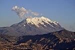
pronunciation: [iʎiˈmani]) is the highest mountain in the Cordillera Real (part of the Cordillera Oriental, a subrange of the Andes) of western Bolivia....
8 KB (812 words) - 03:21, 15 August 2024

when one male was collected and three to four juveniles observed in Apolobamba Integrated Management Natural Area, La Paz. Taczanowski's tinamou inhabits...
7 KB (783 words) - 08:30, 8 October 2022

Umani Wila Wila Wila Wilani Wiluyu Janq'u Uma Yapuchañani Parts of the Apolobamba Integrated Management Natural Area and the Pilón Lajas Biosphere Reserve...
11 KB (298 words) - 19:51, 11 September 2024

Bolivia, located near El Alto and about 25 km north of La Paz in the Cordillera Real. Huayna Potosí is the closest high mountain to La Paz. Surrounded...
8 KB (1,069 words) - 04:15, 6 October 2024
14167°W / -20.33056; -63.14167 Department Santa Cruz Department Province Cordillera Province Elevation 720 m (2,370 ft) Time zone UTC-4 (BOT) Sources: Google...
5 KB (50 words) - 13:14, 23 March 2021

(after Sajama and Illimani). It is located in the northern section of the Cordillera Real, part of the Andes, east of Lake Titicaca. It lies just south of...
3 KB (235 words) - 00:08, 7 December 2023

highest mountain in Bolivia. It is located in the northern section of the Cordillera Real, part of the Andes, east of Lake Titicaca. It lies just north of...
3 KB (220 words) - 00:09, 7 December 2023

east of Lake Titicaca in the La Paz Department. It originates in the Cordillera Real near the peaks of the 6,127 m high Ch'iyar Juqhu which is probably...
3 KB (179 words) - 09:58, 27 October 2019

topography offers views of the city and the surrounding mountains of the Cordillera Real from numerous natural viewing points. La Paz is home to the largest...
75 KB (6,470 words) - 17:16, 27 September 2024

"maize cane step") is a 5,442-metre-high (17,854 ft) mountain in the Cordillera Real in the Andes of Bolivia. It is located in the La Paz Department,...
2 KB (131 words) - 02:23, 16 April 2022
three, Pukina chata mountain, "three mountains") is a mountain in the Cordillera Real in the Andes of Bolivia, about 5,056 metres (16,588 ft) high. It...
3 KB (198 words) - 02:14, 16 April 2022

Mururata is a mountain in the Cordillera Real of Bolivia. Approximately 35 km East of La Paz, the Mururata lies to the North of the Illimani. The Mururata...
3 KB (186 words) - 15:34, 17 June 2024

route of 1911 from La Paz to Pelechuco and Apolo". phfawcettsweb.org. "Apolobamba". bolivianmountains.com. Archived from the original on 2007-10-23. Retrieved...
5 KB (479 words) - 03:49, 28 September 2023
Saltuni is a 5,284-metre-high (17,336 ft) mountain in the Cordillera Real in the Bolivian Andes. It is situated in the La Paz Department, Murillo Province...
2 KB (88 words) - 02:23, 16 April 2022
also spelled Nazacara) is a 5,064-metre-high (16,614 ft) mountain in the Cordillera Real in the Andes of Bolivia. It is situated in the La Paz Department...
2 KB (132 words) - 02:18, 16 April 2022