
Curahuara de Carangas is a small town in the Bolivian Oruro Department. It is the seat of the Sajama Province. In 2009 it had an estimated population...
6 KB (125 words) - 02:12, 21 July 2024

Wila Qullu is situated in the Sajama Province, in the west of the Curahuara de Carangas Municipality, west of the extinct Sajama volcano and north-east...
2 KB (141 words) - 02:35, 16 April 2022
San Pedro Curahuara is a location in the La Paz Department in Bolivia, capital of the province of Gualberto Villarroel Province. (in Spanish) Instituto...
5 KB (51 words) - 12:14, 8 March 2021

Bolivia. It is situated in the Sajama Province, in the west of the Curahuara de Carangas Municipality, at the border with Chile. Patilla Pata lies south-west...
3 KB (210 words) - 20:23, 19 June 2022

Payachata (redirect from Nevadoes de Payachata)
volcanoes are located in the Oruro Department, Sajama Province, Curahuara de Carangas Municipality, and on the Chilean side they lie in the Arica y Parinacota...
3 KB (230 words) - 18:44, 3 April 2023
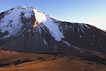
northern Chile and Bolivia (Oruro Department, Sajama Province, Curahuara de Carangas Municipality). It is part of the Payachata complex of volcanoes...
7 KB (644 words) - 00:33, 7 December 2023

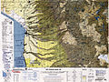
5838-IV Bolivian IGM map 1:50,000 Curahuara de Carangas 5940-III Bolivian IGM map 1:50,000 Estancia Antin Curahuara 5939-III Bolivian IGM map 1:50,000...
8 KB (500 words) - 01:32, 7 October 2024
high. It is situated in the Oruro Department, Sajama Province, Curahuara de Carangas Municipality, Sajama Canton, north-west of the extinct Sajama volcano...
2 KB (173 words) - 02:20, 16 April 2022
Bolivia. It is located in the Oruro Department, Sajama Province, Curahuara de Carangas Municipality. Llisa lies northeast of the Sajama volcano. Bolivian...
2 KB (104 words) - 02:16, 16 April 2022

architecture spread to Colonial Bolivia, with examples being the Church of Curahuara de Carangas built between 1587 and 1608 known as the "Sistine Chapel of the...
96 KB (12,099 words) - 14:16, 10 September 2024
in the Oruro Department, Sajama Province, at the border of the Curahuara de Carangas Municipality and the Turco Municipality. Q'aysiri lies north-east...
2 KB (116 words) - 02:21, 16 April 2022
situated in the Oruro Department, Sajama Province, in the west of the Curahuara de Carangas Municipality, northwest of the extinct Sajama volcano. It lies south...
3 KB (265 words) - 02:19, 16 April 2022
flows to Curahuara de Carangas in the north. Bolivian IGM map 1:50,000 Curahuara de Carangas 5940-III Radio San Gabriel, "Instituto Radiofonico de Promoción...
2 KB (132 words) - 12:23, 29 July 2023

Laca Canton. It is bordered to the north by the Curahuara de Carangas Municipality and San Pedro de Totora Province, to the south by the Litoral and...
16 KB (647 words) - 02:21, 21 July 2024

Bolivia. It is located in the Oruro Department, Sajama Province, Curahuara de Carangas Municipality, Sajama Canton. K'isi K'isini is situated inside the...
3 KB (220 words) - 15:06, 31 July 2022

El Alto (redirect from El Alto de La Paz)
January 24, 2016. "Base de datos Sistema Meteorológico–SISMET" (in Spanish). Servicio Nacional de Meteorología e Hidrología de Bolivia. Archived from the...
19 KB (1,275 words) - 16:27, 9 August 2024
Department, Sajama Province, at the border of the municipalities of Curahuara de Carangas and Turco. Kimsa Misa lies north of Wayna Potosí. Bolivian IGM map...
2 KB (143 words) - 02:14, 16 April 2022

administered by an alcalde and municipal council. Departments of Bolivia Municipalities of Bolivia Instituto Nacional de Estadística - Bolivia (Spanish)...
53 KB (53 words) - 02:16, 7 September 2024
Bolivia. It is situated in the Oruro Department, Sajama Province, Curahuara de Carangas Municipality. Wisalla lies south-west of the dormant Sajama volcano...
2 KB (111 words) - 02:36, 16 April 2022
Bolivia. It is situated in the Oruro Department, Sajama Province, Curahuara de Carangas Municipality, Sajama Canton, near the border to the La Paz Department...
2 KB (126 words) - 02:11, 16 April 2022
Department, Sajama Province, Curahuara de Carangas Municipality, south of Ch'apiri. Bolivian IGM map 1:50,000 Curahuara de Carangas 5940-III Radio San Gabriel...
2 KB (117 words) - 02:12, 16 April 2022

la Gobernación de La Paz". eju.tv. 24 February 2010. Archived from the original on 3 April 2019. Retrieved 2 April 2019. "ELECCIÓN DE AUTORIDADES POLÍTICAS...
15 KB (470 words) - 11:09, 10 September 2024
volcano. It is situated in the Sajama Province, in the west of the Curahuara de Carangas Municipality. According to the Bolivian IGM map 1:50,000 'Nevados...
2 KB (217 words) - 02:22, 16 April 2022

towns in the Bolivian Andes, such as Catavi, Uncía, Corocoro and Curahuara de Carangas. Numerous political opponents of the MNR, both communists and Falangists...
24 KB (2,809 words) - 06:15, 28 September 2024
of the Curahuara de Carangas Municipality. Bolivian IGM map 1:50,000 Estancia Marcarani Hoja 5939-IV Radio San Gabriel, "Instituto Radiofonico de Promoción...
2 KB (170 words) - 02:11, 16 April 2022

Andrés de Machaca (San Andrés de Machaca) San Buenaventura (San Buenaventura) San Pedro de Curahuara (San Pedro de Curahuara de Carangas) San Pedro de Tiquina...
8 KB (1,069 words) - 04:15, 6 October 2024
005 ft). It is situated in the Oruro Department, Sajama Province, Curahuara de Carangas Municipality, Sajama Canton, north-west of the extinct Sajama volcano...
3 KB (177 words) - 02:13, 16 April 2022
in the Oruro Department, Sajama Province, on the border of the Curahuara de Carangas Municipality and the Turco Municipality. Chunkarani is situated...
2 KB (113 words) - 13:21, 13 January 2022
in the Oruro Department, Sajama Province, at the border of the Curahuara de Carangas Municipality and the Turco Municipality. Chilli Qhata lies south-west...
2 KB (133 words) - 02:09, 16 April 2022

La Paz (redirect from Nuestra Señora de La Paz)
La Paz, officially Nuestra Señora de La Paz, is the seat of government of the Plurinational State of Bolivia. With 755,732 residents as of 2024, La Paz...
75 KB (6,470 words) - 17:16, 27 September 2024