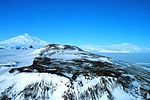
Eastwind Ridge (76°36′S 160°47′E / 76.600°S 160.783°E / -76.600; 160.783 (Eastwind Ridge)) is a broad, partially ice-covered ridge about 10 nautical...
4 KB (661 words) - 00:40, 10 February 2024

Convoy Range (section Eastwind Ridge)
Hills and Wyandot Ridge to join the Mawson Glacier. The Chattahoochee Glacier runs northeast from between Wyandot Ridge and Eastwind Ridge in the north of...
7 KB (955 words) - 13:26, 12 March 2024
Mount Terror (Antarctica) (redirect from Giggenbach Ridge)
east of the head of Eastwind Glacier and 4 nautical miles (7.4 km; 4.6 mi) northeast of Conical Hill. Names in association with Eastwind Glacier after Captain...
14 KB (2,360 words) - 04:46, 29 May 2024
Glacier in the Convoy Range which flows northeast between Wyandot Ridge and Eastwind Ridge. Mapped by the United States Geological Survey (USGS) from ground...
7 KB (1,097 words) - 22:22, 29 January 2024
Dana Mountains (redirect from Galan Ridge)
the Palmer Station-Eastwind Expedition, summer 1965-66. 73°10′S 62°00′W / 73.167°S 62.000°W / -73.167; -62.000. A prominent ridge which forms the northeast...
9 KB (1,487 words) - 14:30, 28 April 2024
the Antarctic, including the 1964 visit of the US Coast Guard icebreaker Eastwind, which ran aground inside the harbour. However, the volcano returned to...
39 KB (4,020 words) - 15:31, 26 August 2024

glacier runs east of northeast to Fry Glacier between Elkhorn Ridge to the south and Eastwind Ridge to the north. The valley is at its former head. Features...
3 KB (332 words) - 18:01, 21 July 2024
EASTERN SKYJETS United Arab Emirates DK ELA Eastland Air Australia W9 SGR Eastwind Airlines STINGER United States defunct FYE Easy Link Aviation Services...
3 KB (784 words) - 00:36, 18 July 2024
Cook Mountains (redirect from DeZafra Ridge)
1959-63. Named by US-ACAN for Capt. B.R. Henry, USCG, commander of the Eastwind USN OpDFrz, 1964, and commander of the U.S. ship group, OpDFrz, 1965. 79°16′S...
20 KB (3,424 words) - 14:05, 12 March 2024

Eastwind, Lower Strata, Sidewinder Most Difficult Trails: White Lightning, Upper Blue Streak Extremely Difficult Trails: Upper Ultra, Upper Eastwind,...
7 KB (672 words) - 22:35, 27 November 2022
Durant Partners Justin Udelhofen Active 2016–Present Water Street Capital Eastwind Global Naveen Choudary Active 2012–Present Shumway Capital Electron Capital...
19 KB (240 words) - 14:41, 23 July 2024
30 5 "Hidden Danger" United Airlines Flight 585, USAir Flight 427, and Eastwind Airlines Flight 517 13 May 2007 (2007-05-13) On 3 March 1991, a Boeing...
233 KB (786 words) - 12:36, 27 August 2024
a fire in its cargo hold. All 110 people on board are killed. June 9 – Eastwind Airlines Flight 517, a Boeing 737-200, loses rudder control while on approach...
370 KB (55,427 words) - 22:04, 27 August 2024
(WAGB-278) (1944–1974; ex-Severny Veter, ex-Northwind; broken up) USCGC Eastwind (WAGB-279) (1944–1968; broken up in 1976–1977) USCGC Southwind (WAGB-280)...
73 KB (5,610 words) - 10:11, 23 August 2024

County, Virginia, on January 18, 1960, killing all 50 people on board. Eastwind Airlines Flight 517 suffered an in-flight rudder malfunction on June 9...
148 KB (15,924 words) - 19:22, 14 August 2024

children's play equipment along with adjoining trail systems. In Viera West, Eastwind Park, Westwind Park, North Solerno Park, Palmentto Park, Woodmill Park...
24 KB (2,434 words) - 18:32, 10 July 2024

different points along SR 659 Gloucester 0.22 0.35 SR 623 (Ware Neck Road) Eastwind Road Dead End Goochland 0.25 0.40 Dead End Childress Road SR 622 (Rockville...
33 KB (1,772 words) - 18:45, 16 February 2024
by US-ACAN for Edward J. Racine, a member of the crew of the icebreaker Eastwind in Operation Deep Freeze 1967. 85°24′S 136°12′W / 85.400°S 136.200°W...
18 KB (2,906 words) - 13:47, 17 January 2024
service. October 11, 1946: Flight 546, a Douglas C-54B (NC88729), struck a ridge near Alexandria, Virginia while on approach to Washington National Airport;...
67 KB (7,487 words) - 15:12, 24 July 2024
Named by US-AC AN for William A. Babis, USARP oceanographer on the USCGC Eastwind, 1962-63, and on the USS Burton Island, 1963-64. 82°14′S 163°47′E / 82...
13 KB (1,641 words) - 22:28, 17 August 2024
Everything Messer's Lore Double Entendre The Tommyhawks Los Kumbia Killers Eastwinds Red Sea Pedestrians The Pioneers Loaded Dog Shelter Poets Breakfast with...
62 KB (8,857 words) - 03:28, 10 May 2024