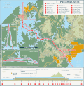
and low Isthmus of Panama. This S-shaped isthmus is situated between 7° and 10° north latitude and 77° and 83° west longitude. Panama encompasses approximately...
29 KB (2,359 words) - 23:47, 15 October 2024
The Panama Canal (Spanish: Canal de Panamá) is an artificial 82-kilometer (51-mile) waterway in Panama that connects the Caribbean Sea with the Pacific...
147 KB (15,598 words) - 00:51, 1 January 2025
Panama, officially the Republic of Panama, is a country in Latin America at the southern end of Central America, bordering South America. It is bordered...
133 KB (13,608 words) - 17:44, 2 January 2025
Isla Vivenda Isla Viveros Isla Barro Colorado Isla Gatun Isla Tres Perros Geography of Panama "Islands of Panama". GeoNames. Retrieved October 3, 2021....
3 KB (213 words) - 16:26, 19 August 2024
of Panama Geography of Greenland Geography of the Lucayan Archipelago Geography of the Bahamas Geography of the Turks and Caicos Islands Geography of Mexico...
31 KB (3,422 words) - 11:48, 31 December 2024
The Panama Canal Zone (Spanish: Zona del Canal de Panamá), also simply known as the Canal Zone, was a concession of the United States located in the Isthmus...
67 KB (7,325 words) - 08:31, 31 December 2024
Pacific coast (category Coastal geography)
Pacific Coast of Mexico Geography of Nicaragua Geography of Panama West Coast of the United States Geography of Alaska Only four countries in South America...
4 KB (461 words) - 20:10, 17 December 2024
The idea of the Panama Canal dates back to 1513, when the Spanish conquistador Vasco Núñez de Balboa first crossed the Isthmus of Panama. European powers...
110 KB (14,005 words) - 14:00, 4 January 2025
Panamá is a district (distrito) of Panamá Province in Panama. The population according to the 2010 census was 880,691; the latest official estimate (for...
5 KB (69 words) - 22:37, 15 April 2024
Lake Alajuela (category Geography of Panamá Province)
rivers of Lake Alajuela contribute 45 percent of the total water for the canal. As of 1987, it provided all of the drinking water for Panama City. The...
4 KB (294 words) - 08:38, 30 October 2024
Panama City, also known as Panama (or Panamá in Spanish), is the capital and largest city of Panama. It has a total population of 1,086,990, with over...
64 KB (5,791 words) - 17:05, 4 January 2025
The history of Panama includes the history of the Isthmus of Panama prior to European colonization. Before the arrival of Europeans, Panama was widely...
60 KB (8,305 words) - 16:44, 30 November 2024
deprived it of a local currency. Panama is a high income economy with a history of low inflation. Since the early 16th century, Panama's geographic location...
34 KB (2,859 words) - 00:49, 18 November 2024
file zone.tab—America/Panama. "PA" refers to the country's ISO 3166-1 alpha-2 country code. Data for Panama directly from zone.tab of the IANA time zone...
2 KB (104 words) - 20:55, 4 June 2024
between Costa Rica and Panama is 348 km (216 mi) long. The border in its present state is demarcated by the Echandi-Fernandez Treaty of 1941. The border between...
2 KB (208 words) - 11:44, 23 December 2024
See ISO 3166-2:PA Internet country code top-level domain: .pa Geography of Panama Panama is: a country Location: Northern Hemisphere and Western Hemisphere...
14 KB (910 words) - 15:42, 28 October 2024
The Isthmus of Panama (Spanish: Istmo de Panamá) is the narrow strip of land that lies between the Caribbean Sea and the Pacific Ocean, linking North...
22 KB (2,528 words) - 19:09, 25 October 2024
In Panama, a corregimiento is a subdivision of a district, which in turn is a subdivision of a province. It is the smallest administrative division level...
31 KB (135 words) - 12:20, 30 April 2024
Panama (Spanish: Panamá) is a province of Panama. It is the location of the national capital Panama City, which also serves as the provincial capital...
8 KB (195 words) - 14:05, 25 October 2024
a corregimiento (municipality). ISO 3166-2:PA List of provinces and indigenous regions of Panama by Human Development Index "Cuadro 11. Superficie, población...
7 KB (94 words) - 11:46, 25 October 2024
Ciudad del Saber (redirect from Ciudad del Saber, Panama)
79.583°W / 8.999; -79.583 Panama's Ciudad del Saber (Spanish for City of Knowledge) is a government-sponsored cluster of academic organizations, technology...
5 KB (456 words) - 04:18, 3 December 2021
mountainous part of Panama Province. There is a well marked road leading to Cerro Azul from the 24 de Diciembre town of the Panama District of Panama City. The...
2 KB (197 words) - 03:53, 16 September 2024
Darién Gap (redirect from Region of Darién)
plug') is a geographic region that connects the American continents, stretching across southern Panama's Darién Province and the northern portion of Colombia's...
56 KB (5,777 words) - 11:49, 1 January 2025
of Panama Category:Economy of Panama Category:Education in Panama Category:Environment of Panama Category:Geography of Panama Category:Government of Panama...
10 KB (1,112 words) - 19:23, 13 December 2024
Caribbean Lowlands (category Geography of Panama)
Nicaragua, Costa Rica, and Panama. The lowlands are mainly between the major American Cordillera System ranges running down the center of the Central American...
3 KB (273 words) - 19:52, 18 May 2024
Isthmus of Panama from Colón (Atlantic) to Balboa (Pacific, near Panama City). Because of the difficult physical conditions of the route and state of technology...
53 KB (6,915 words) - 23:04, 5 November 2024
was more or less part of the Panama Canal township of Balboa, existing on its edge, towards Ancón, and partly on the lower slopes of Ancon Hill. It was not...
2 KB (160 words) - 19:02, 29 October 2024
San Miguelito District (redirect from San Miguelito, Panama)
San Miguelito is a city and district (distrito) of Panamá Province in Panama. The population according to the 2000 census was 293,745; the latest official...
5 KB (189 words) - 15:38, 10 July 2024
The Panama plate is a small tectonic plate (microplate) that exists between two actively spreading ridges and moves relatively independently of its surrounding...
6 KB (728 words) - 03:41, 10 November 2024
provided as an overview of and topical guide to geography: Geography – study of Earth and its people. an academic discipline – a body of knowledge given to...
86 KB (7,679 words) - 11:24, 25 November 2024


