
The international border between Guatemala and Mexico measures 871 km (541 mi). It runs between north and west Guatemala (the Guatemalan departments of San...
12 KB (1,428 words) - 06:22, 27 June 2024
following the course of the Río Hondo. Also to the southeast, the Guatemala–Mexico border, which measures 871 kilometres (541 mi) and touches the states...
3 KB (265 words) - 22:47, 28 May 2024

Garbutt's Falls due north until it strikes the Mexican frontier. The border has been disputed by Guatemala, which claims that the treaty is void since Britain...
3 KB (301 words) - 08:06, 17 July 2024

Guatemalan and Mexican governments had quarreled over the crossing of the Guatemalan border by Mexican citizens. On November 8, 1957, the Guatemalan Foreign...
10 KB (946 words) - 23:27, 4 June 2024

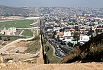
The Mexico–United States border crisis is an ongoing migrant crisis in North America concerning the migration of illegal immigrants from Latin America...
49 KB (5,072 words) - 19:34, 28 July 2024
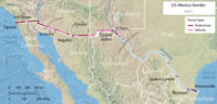
Canada–United States border; Mexico has two other borders: with Belize and with Guatemala. The Mexico-U.S. border is the tenth-longest border between two countries...
130 KB (14,297 words) - 12:35, 7 July 2024

Guatemala and Mexico are neighboring nations who established diplomatic relations in 1848. In January 1959 both nations broke diplomatic relations as a...
20 KB (1,913 words) - 06:22, 27 June 2024
The Mexico–United States border wall (Spanish: muro fronterizo Estados Unidos–México) is a series of vertical barriers along the Mexico–United States...
90 KB (8,975 words) - 21:15, 25 July 2024
borders of Guatemala are the international borders which it shares with four nations: Mexico Honduras Belize El Salvador Over its history Guatemala has...
5 KB (486 words) - 06:43, 9 January 2022

Belize–Guatemala border Foreign relations of Belize Foreign relations of Guatemala Sarstoon Island Sapodilla Cayes Chiapas (incl. Soconusco), a Mexican state...
53 KB (5,850 words) - 08:07, 17 July 2024
Recently, many Guatemalans have been immigrating to Mexico rather than the United States. Most settle around Guatemala-Mexico border states to keep in...
4 KB (260 words) - 22:59, 9 July 2023
country. 12 May: A magnitude 6.4 earthquake strikes along the Guatemala-Mexico border, causing damage in Quetzaltenango and San Marcos Departments. 17...
6 KB (528 words) - 02:58, 27 July 2024
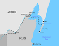
The Belize–Mexico border is an international border between Belize and Mexico. It is 250 km (160 mi) long and almost exclusively follows the course of...
7 KB (874 words) - 01:33, 18 June 2024

Usumacinta River (category Guatemala–Mexico border)
which descends from the Sierra Madre de Guatemala. It defines part of the border between Guatemala and the Mexican state of Chiapas, then continues its northwesterly...
11 KB (1,109 words) - 06:56, 6 January 2024

San Marcos Department (redirect from San Marcos Department, Guatemala)
Marcos is a department in northwestern Guatemala, on the Pacific Ocean and along the western Guatemala-Mexico border. The department's capital is the city...
23 KB (1,638 words) - 09:28, 1 May 2024

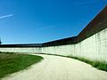
Ciudad Hidalgo, Chiapas (category Guatemala–Mexico border crossings)
international border with Guatemala. The Puente Rodolfo Robles, a road-rail bridge, over the Río Suchiate joins it with the Guatemalan city of Ciudad...
8 KB (337 words) - 00:15, 27 June 2024

Central American migrant caravans (category Mexico–United States border)
are migrant caravans that travel from Central America to the Mexico–United States border to demand asylum in the United States. The largest and best known...
85 KB (6,453 words) - 23:15, 3 July 2024
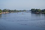
Suchiate River (category Guatemala–Mexico border)
river that marks the southwesternmost part of the border between Mexico (state of Chiapas) and Guatemala (department of San Marcos). From its sources on...
3 KB (203 words) - 23:56, 26 May 2024
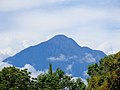
Volcán Tacaná (category Guatemala–Mexico border)
located in the Sierra Madre de Chiapas of northern Guatemala and southern Mexico. It is also known in Mexico as Volcán Tacina. The volcano is located within...
7 KB (641 words) - 18:00, 24 January 2024
Guatemala, officially the Republic of Guatemala, is a country in Central America. It is bordered to the north and west by Mexico, to the northeast by Belize...
198 KB (19,564 words) - 18:55, 14 July 2024

east. The border dispute and being adjudicated in the ICJ as of 2019. Its length is 256 km (159 mi). It is the third longest border of Guatemala after the...
3 KB (252 words) - 21:27, 14 February 2024

The United States border with Mexico is one of the world's "most lethal land borders". Hundreds of migrants die per year as they attempt to cross into...
36 KB (3,705 words) - 21:51, 1 June 2024
Transportation in Guatemala includes roads, waterways, airports and a short cross-border rail line from Mexico. The Ministry of Communications, Infrastructure...
8 KB (710 words) - 11:54, 2 June 2024
La Mesilla (category Guatemala–Mexico border crossings)
Huehuetenango Department, Guatemala. It is the home of Peñarol La Mesilla football club. La Mesilla lies close to the border with Mexico, between Huehuetenango...
5 KB (64 words) - 07:20, 13 October 2019

western highlands is marked by the Sierra Madre, which stretches from the Mexican border south and east, and continues at lower elevations toward El Salvador...
16 KB (1,224 words) - 01:28, 23 June 2024

Tapachula (redirect from Tapachula, Mexico)
municipality located in the far southeast of the state of Chiapas, México, near the Guatemalan border and the Pacific Ocean. Economically, it is one of the most...
49 KB (4,046 words) - 13:49, 2 May 2024
rivers)) to form the Usumacinta river which flows into the Gulf of Mexico. Guatemala's National Institute for Electricity (INDE) is planning the construction...
3 KB (266 words) - 08:15, 6 January 2024
largest source of illegal immigrants in Mexico are the impoverished Central American countries of Guatemala, Haiti, Honduras, and El Salvador and African...
21 KB (2,596 words) - 19:23, 23 June 2024

Flores, Petén (redirect from Flores, Guatemala)
was in charge of the Guatemala-Mexico Border Commission. Flores, as seen from San Benito Engineering crew of the Guatemalan Border Commission. Claudio...
14 KB (759 words) - 19:36, 22 June 2024

across the breadth of Guatemala, from the Salvadorian border to the Mexican border. Lying on the Ring of Fire, the Guatemalan highlands and the Valle...
70 KB (5,536 words) - 02:54, 21 July 2024