
Kentucky Route 461 (KY 461) is a 18.015-mile-long (28.992 km) state highway in the U.S. state of Kentucky. The highway connects mostly rural areas of...
5 KB (340 words) - 17:51, 16 February 2024
numbered 461: Newfoundland and Labrador Route 461 Japan National Route 461 Iowa Highway 461 Kentucky Route 461 Maryland Route 461 New Mexico Highway 461 Puerto...
856 bytes (77 words) - 22:27, 4 April 2024

have portions within the State Primary and State Secondary systems. Kentucky Route 400 is a 1.377-mile-long (2.216 km) supplemental road in the city of...
131 KB (12,134 words) - 17:05, 29 April 2024

State Route 461 (SR 461) is a state highway located entirely in Stewart County, Tennessee. SR 461 begins at an intersection with US 79 with unsigned companion...
4 KB (231 words) - 01:08, 31 July 2023
Kentucky Route 1250 just north of its terminus on Kentucky Route 461. U.S. Geological Survey Geographic Names Information System: Wabd, Kentucky Rennick...
3 KB (72 words) - 20:40, 29 July 2023

Kentucky Route 80 (KY 80) is a 483.55-mile-long (778.20 km) state highway in the southern part of the U.S. state of Kentucky. The route originates on...
64 KB (1,742 words) - 21:16, 14 May 2024

Kentucky, via US 127 and Kentucky state highways 90, 1247, 914, 80 and 461. Kentucky Route 202 is a 10.281-mile-long (16.546 km) rural secondary highway in...
91 KB (9,054 words) - 18:30, 9 May 2024
allusions to the Gothic Revival style in the county." It is located on Kentucky Route 461. "National Register Information System". National Register of Historic...
2 KB (146 words) - 05:33, 6 August 2023

Illinois to U.S. Route 25 in Mount Vernon, Kentucky. In the state of Illinois, U.S. 150 runs from the Quad City International Airport at U.S. Route 6 southeast...
31 KB (1,002 words) - 05:11, 21 October 2023

Kentucky Route 90 (KY 90) is a major east–west state highway in southern Kentucky. The route is 134.734 miles (216.833 km) long, and it traverses Barren...
35 KB (2,446 words) - 21:13, 14 May 2024

special routes of U.S. Route 68 exist from Kentucky to Ohio. In order from west to east in Kentucky, and south to north in Ohio, these special routes are...
19 KB (808 words) - 19:04, 17 April 2024
Kentucky are maintained by the Kentucky Transportation Cabinet, which classifies routes as either primary or secondary. Some routes, such as Kentucky...
31 KB (125 words) - 16:22, 18 May 2024

the Kentucky border. Sometime in the 2000s, this portion was redesignated as SR 461. Google Maps and some recent road maps still displays SR 461 as SR...
14 KB (881 words) - 16:04, 4 December 2023

U.S. Route 60 (US 60) is a major U.S. Highway in the American state of Kentucky. In the early days of the U.S. Highway System, US 60 was originally to...
75 KB (1,848 words) - 23:01, 8 March 2024
U.S. Route 68 (US 68) is a United States highway that runs for 560 miles (900 km) from northwest Ohio to Western Kentucky. The highway's western terminus...
68 KB (1,546 words) - 05:30, 9 February 2024

Kentucky Route 79 (KY 79) is a 102-mile-long (164 km) north–south state highway that traverses five counties in west-central Kentucky. It can be seen...
16 KB (910 words) - 23:09, 10 February 2024
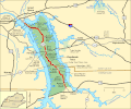
The Trace (Land Between the Lakes) (category Transportation in Trigg County, Kentucky)
winding path of buffalo or bison. The Trace begins as Tennessee State Route 461 (SR 461, locally known as The Trave Road) at the intersection with US 79 (running...
13 KB (1,030 words) - 12:01, 5 April 2024

Kentucky Route 70 (KY 70) is a long east-east state highway that originates at a junction with U.S. Route 60 (US 60) in Smithland in Livingston County...
58 KB (3,304 words) - 18:56, 22 May 2024

Kentucky Route 11 (KY 11) is an American highway maintained by the Kentucky Transportation Cabinet that runs from Maysville to Barbourville. The route...
49 KB (3,535 words) - 12:45, 11 April 2023
List of highways numbered 1000–1499 (redirect from Route 1128)
listed below are all in the United States, primarily Louisiana, Texas, and Kentucky, though there are some roads in this range in Georgia and New Mexico. The...
55 KB (154 words) - 14:05, 5 April 2024
Hal Rogers Parkway (redirect from Kentucky Route 9006)
designated unsigned Kentucky Route 9006 (HR 9006). An extension of the Hal Rogers Parkway name west along Kentucky Route 80 (KY 80) to U.S. Route 27 (US 27) in...
15 KB (1,045 words) - 17:46, 27 January 2024

Static, at the Tennessee/Kentucky state line. The length is 116 mi (186.7 km). The highway begins at an interchange with U.S. Route 27/SR 29 (US 27/SR 29)...
18 KB (1,131 words) - 10:28, 11 August 2023

It runs from Tennessee State Route 51 at the Kentucky-Tennessee border south of Hestand to U.S. Route 68, Kentucky Route 80, and East Stockton Street...
7 KB (453 words) - 09:32, 23 June 2023

U.S. Route 25 (US 25) runs for 176.882 miles (284.664 km) across the state of Kentucky from the split between US 25E and US 25W in North Corbin to US 42/US 127...
27 KB (424 words) - 23:20, 24 November 2023

the U.S. Route 25 (US 25) corridor for the entire length of Kentucky. I-75 runs roughly parallel to US 25 for its entire length in Kentucky. The freeway...
24 KB (1,222 words) - 01:19, 16 June 2024

of the National Register of Historic Places listings in Pulaski County, Kentucky. This is intended to be a complete list of the properties and districts...
16 KB (401 words) - 16:23, 28 November 2023

Creek 25 miles (40 km) to Inez. Kentucky Route 32 leads southwest from Louisa 18 miles (29 km) to Blaine. West Virginia Route 37 leads east across the Tug...
15 KB (1,436 words) - 15:45, 14 June 2024

Route 460 (US 460) is a part of the U.S. Highway System that travels from Frankfort, Kentucky, to Norfolk, Virginia. In the U.S. state of Kentucky, US 460...
24 KB (192 words) - 14:17, 19 June 2024

Kentucky Route 453 (KY 453) is a 16.040-mile-long (25.814 km) state highway in Kentucky that runs from The Trace at the northern entrance of Land Between...
6 KB (432 words) - 17:50, 16 February 2024

Kentucky Route 36 (KY 36) is a 149.793-mile-long (241.068 km) state highway in Kentucky that runs from US 421 in Milton to US 460 in Frenchburg. KML file...
12 KB (55 words) - 17:48, 16 February 2024