
The Lappwald is a heavily wooded range of hills, 20 km long and up to 5 km wide, in central Germany. It stretches northwards from the town of Helmstedt...
4 KB (434 words) - 01:05, 4 March 2021

The Elm-Lappwald Nature Park (German: Naturpark Elm-Lappwald) is a nature park in southwest Lower Saxony, east of Brunswick in central Germany. It is dominated...
6 KB (794 words) - 02:07, 29 November 2023
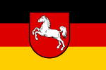
Leine Uplands, Schaumburg Land, Brunswick Land, Untereichsfeld, Elm, and Lappwald. In the northeast of Lower Saxony is the Lüneburg Heath. The heath is dominated...
65 KB (6,641 words) - 10:36, 18 July 2024
chain) in the west and the Lappwald (a riparian forest) in the east. Large parts of the district are part of the Elm-Lappwald Nature Park. In the Elm limestone...
4 KB (367 words) - 00:36, 31 March 2024
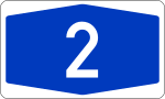
situated near the East German village of Marienborn at the edge of the Lappwald. The crossing interrupted the Bundesautobahn 2 (A 2) between the junctions...
73 KB (8,384 words) - 20:03, 16 July 2024
situated near the East German village of Marienborn at the edge of the Lappwald. The crossing interrupted the Bundesautobahn 2 (A 2) between the junctions...
8 KB (946 words) - 19:16, 21 July 2024
mountain range in the south and the Lüneburg Heath in the north. The Elm-Lappwald Nature Park and the Asse hill range stretch east and southeast of the town...
18 KB (1,862 words) - 13:16, 14 July 2024

and West Berlin. Helmstedt is situated in a basin between the Elm and Lappwald hill ranges, at the transition area between the northern foothills of the...
10 KB (991 words) - 08:04, 12 June 2024

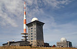
triassic limestone called Elmkalkstein. Together with the neighbouring Lappwald range, the Elm has been a protected nature park since 1977. The Elm is...
2 KB (214 words) - 21:38, 20 October 2022

located on the northeastern slopes of the Elm hill range, within the Elm-Lappwald Nature Park, about 23 km (14 mi) east of Brunswick, 15 km (9.3 mi) west...
7 KB (623 words) - 11:05, 28 May 2023
Rennau (61) Helmstedt-West B 244 (62) Helmstedt-Zentrum Services Helmstedt/Lappwald (63) Helmstedt-Ost B 1 (63) Marienborn / Helmstedt Services Marienborn...
11 KB (1,643 words) - 04:11, 6 July 2024

Elm-Lappwald Lower Saxony 1976 470 The park includes the northern portion of the mid-German Harz mountains and the forested ridges of the Lappwald, Dorm...
48 KB (359 words) - 19:51, 7 September 2023

Hartward Landwehr Himmelpforten Landwehr near Soest Helmstedt Landwehr in the Lappwald Kastel Landwehr (Kastel, also called the Mainz Landwehr ) Lambertsgraben...
32 KB (3,907 words) - 15:03, 27 March 2023

Oebisfelde-Weferlingen. Eschenrode lies about 5 km southeast of Weferlingen, between Lappwald and the Flechtingen Hills. The nearest large towns are Braunschweig, Wolfsburg...
4 KB (296 words) - 14:39, 31 October 2022

the Magdeburg Börde on the Aller River at the northeastern rim of the Lappwald hill range. It is located about 4 km (2.5 mi) south of Weferlingen, near...
4 KB (416 words) - 14:32, 11 June 2024

upper Aller river in present-day Saxony-Anhalt. It was bounded by the Lappwald hill range and the Drömling swamp in the northwest, the River Bode in the...
3 KB (351 words) - 14:10, 8 August 2018
Börde district, Lappwald Edelberg (209 m), Börde district, Hohes Holz Kniel (205 m), Börde district, southeastern extension of the Lappwald Ridge Hohe Gieck...
4 KB (374 words) - 17:47, 8 May 2022
approximately consisted of the area between the river Oker in the west and the Lappwald forest in the east. It was bordered by (from the north, clockwise): Bardengau...
3 KB (324 words) - 18:05, 13 January 2022

the east and another range of hills to the west that stretches from the Lappwald over the Hohes Holz as far as Oschersleben (Bode). The river passes the...
37 KB (4,634 words) - 01:23, 13 April 2024

Heinz (1998). "Das Eisenbahnunglück in Langenweddingen". Börde, Bode und Lappwald. Heimatschrift des Landkreises Bördekreis (in German): 61–64. Endisch,...
7 KB (697 words) - 06:35, 23 September 2023

hilly region forms the southern part of a ridge that stretches from the Lappwald range in the north along the upper Aller river to the Bode basin near Oschersleben...
2 KB (337 words) - 04:13, 14 September 2019

situated on the river Aller, in the lowland between the foothills of the Lappwald and the Osterberg (166 m (545 ft)). In the west is a forest of 24 ha (59...
3 KB (299 words) - 10:05, 10 November 2022

Braunschweig, and also non-executive director of the AWO seniors and Pflege Elm-Lappwald gGmbH. "Abgeordnetenwatch.de: Achim Barchmann (SPD)". Archived from the...
4 KB (380 words) - 16:41, 25 September 2022
MHE’s main line. Between Eilsleben and Brunswick the line crosses the Lappwald ridge and the Elm hills. The line is winding and passes over embankments...
13 KB (1,139 words) - 20:02, 13 July 2020
Döhren is located about two km north of Helmstedt, on the border of the Lappwald mountain range. In 1910 there were 434 residents in Döhren. From 1994 until...
6 KB (723 words) - 12:05, 27 September 2023