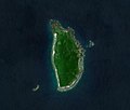
Mavulis Island is the northernmost of the Batanes Islands and the northernmost island in the Philippines. It is part of the archipelagic province of Batanes...
9 KB (808 words) - 18:12, 14 August 2024

Itbayat (redirect from Itbayat Island)
uninhabited. These islands are, from south to north: Di'nem Island, Siayan, Misanga, Ah'li, and Mavulis Island, the northernmost island of the Philippine...
28 KB (1,958 words) - 04:53, 10 August 2024

about 5 miles (8.0 km) north-northeastward of Itbayat Island. The closest island is Mavulis Island which is about 1.5 miles (2.4 km) north-northeastward...
3 KB (171 words) - 18:05, 14 August 2024
巴士海峽; pinyin: Bā shì hǎi xiá) is a waterway between Mavulis Island of the Philippines and Orchid Island of Taiwan. It is a part of the Luzon Strait between...
3 KB (292 words) - 19:04, 9 June 2024
Mavulis (Y'Ami) Frances Reef Balabac Great Reef Pag-Asa (disputed) Pusan Point Mt. Apo Emden Deep (approx. location) This is a list of points in the Philippines...
6 KB (495 words) - 01:56, 26 July 2024

Philippines constructed Filipino fishermen shelters on Mavulis Island, the northernmost island of the Philippines, to aid Filipino fishermen stranded...
32 KB (3,375 words) - 23:19, 28 August 2024

Batanes (redirect from Batanes Islands)
is Mavulis (or Y'ami) Island. Other islands in the chain are Misanga (or North), Ditarem, Siayan, Diogo (or Dinem), Ivuhos, and Dequey. The islands are...
48 KB (4,874 words) - 01:47, 4 September 2024

with the frigate Wu Chang (FFG-1205) of the Taiwanese Navy near the Mavulis Island in Batanes. The two ships implemented the Naval Code for Unplanned Encounters...
20 KB (1,554 words) - 18:27, 1 July 2024

Standard Time (UTC+08) Extreme points of the Philippines North: Mavulis (Y'Ami) Island, Itbayat, Batanes 21°7′18.41″N 121°56′48.79″E / 21.1217806°N 121...
34 KB (2,439 words) - 15:02, 18 August 2024

Lak-Indo Study Group. 1983. p. 68. Joseph, Dishan (16 July 2016). "Mannar Island of Martyrs » Nation". Nation. Archived from the original on 3 March 2018...
5 KB (353 words) - 10:01, 4 May 2023