
New Hampshire Route 25 is a 96.62-mile (155.49 km) long east–west state highway in New Hampshire. It runs completely across the state from Vermont to Maine...
22 KB (1,714 words) - 13:19, 28 December 2023

New Hampshire Route 3A is a designation held by two separate state highways in New Hampshire. The two segments, although not directly connected, are linked...
15 KB (853 words) - 18:13, 31 May 2024

New Hampshire Route 16 (NH 16) is a 154.771-mile (249.080 km), north–south state highway in New Hampshire, United States, the main road connecting the...
22 KB (1,594 words) - 01:32, 28 April 2024

diagonal routes). The Massachusetts Highway Commission convinced the rest of southern New England and New York to use this system in 1915 (New Hampshire and...
158 KB (6,445 words) - 17:10, 1 February 2024

New Hampshire Route 11 is a 108.223-mile-long (174.168 km) east–west state highway in New Hampshire, running completely across the central part of the...
24 KB (1,613 words) - 16:42, 20 February 2024

U.S. Route 3 (US 3) is a United States Numbered Highway running 277.90 miles (447.24 km) from Cambridge, Massachusetts, through New Hampshire, to the Canada–United...
55 KB (3,184 words) - 21:33, 14 July 2024

place (CDP) and is located at the junction of U.S. Route 3 and New Hampshire Route 25 with NH Route 132. Ashland was once the southwestern corner of Holderness...
13 KB (1,067 words) - 13:36, 3 May 2024

New Hampshire Route 101 (NH 101) is a state-maintained highway in southern New Hampshire extending from Keene to Hampton Beach. It is the major east–west...
37 KB (3,355 words) - 13:01, 24 May 2024

New Hampshire Route 9 (abbreviated NH 9 and also known as the Franklin Pierce Highway) is a 109.910-mile-long (176.883 km) state highway located in southern...
24 KB (1,535 words) - 00:04, 12 May 2024

New Hampshire Route 10 is a 122.25-mile-long (196.74 km) north–south state highway in western New Hampshire, United States. Its southern terminus is in...
18 KB (1,257 words) - 02:38, 25 March 2023

New Hampshire Route 28 is an 85.413-mile-long (137.459 km) north–south state highway in eastern New Hampshire. It connects the town of Ossipee in east-central...
19 KB (1,359 words) - 12:22, 8 July 2024
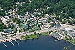
census-designated place, and is located at the junction of U.S. Route 3 and New Hampshire Route 25 at the head of Meredith Bay on Lake Winnipesaukee. Meredith...
24 KB (1,833 words) - 15:16, 9 June 2024

113 begins in the Lakes Region at an intersection with U.S. Route 3 and New Hampshire Route 25 in Holderness, and stretches eastward across the central part...
11 KB (873 words) - 13:57, 4 August 2023

part of the state. SR 25 begins at the New Hampshire border near Porter, where it continues west as New Hampshire Route 25 (NH 25). Its eastern terminus...
12 KB (872 words) - 18:09, 16 June 2024

joining with Route 10 to head northeast to Bath and Littleton. New Hampshire Route 25 enters Haverhill from Piermont while co-signed with Route 10, splitting...
19 KB (1,596 words) - 14:29, 3 May 2024

New Hampshire Route 108 is a 42.430-mile-long (68.284 km) north–south state highway in Rockingham and Strafford counties in southeastern New Hampshire...
15 KB (873 words) - 04:58, 7 November 2023

Route 25 (VT 25) is a 17.739-mile-long (28.548 km) north–south state highway in Orange County, Vermont, United States. It begins at the New Hampshire...
6 KB (462 words) - 18:23, 4 March 2024

west to east through the center of the town, roughly paralleled by New Hampshire Route 25. The town is part of the Pemigewasset River watershed, leading to...
13 KB (1,026 words) - 17:05, 3 May 2024

town by area in New England. U.S. Route 3 is the only major highway in the town, although the northern terminus of New Hampshire Route 145 also lies within...
20 KB (1,512 words) - 12:46, 10 June 2024

U.S. Route 1 (US 1) is a north–south U.S. Route is the U.S. state of New Hampshire through Hampton and Portsmouth. It lies between Interstate 95 (I-95)...
16 KB (1,200 words) - 12:20, 29 April 2024

New Hampshire Route 132 (abbreviated NH 132) is a 40.012-mile-long (64.393 km) north–south highway in Belknap and Merrimack counties in central New Hampshire...
10 KB (698 words) - 03:07, 25 March 2023

along New Hampshire Route 27 just west of New Hampshire Route 125. Epping was originally part of Exeter, one of the four original New Hampshire townships...
23 KB (1,744 words) - 06:23, 29 March 2024

New Hampshire (/ˈhæmpʃər/ HAMP-shər) is a state in the New England region of the Northeastern United States. It borders Massachusetts to the south, Vermont...
127 KB (11,676 words) - 16:24, 3 August 2024

S. Route 3 New Hampshire Route 3A New Hampshire Route 28 New Hampshire Route 28A NH 28 Bypass, known as Londonderry Turnpike. New Hampshire Route 101...
81 KB (6,681 words) - 00:05, 14 August 2024
head of Moultonborough Bay, at the intersection of New Hampshire Route 25 and Route 109. Route 25 is a major east-west highway in the state, connecting...
16 KB (1,357 words) - 12:22, 29 July 2024

White Mountain National Forest. Warren is crossed by New Hampshire Route 25 and New Hampshire Route 118. As of the census of 2010, there were 904 people...
14 KB (1,102 words) - 17:12, 3 May 2024

New Hampshire Route 175 (NH 175) is a state highway in the U.S. state of New Hampshire. The highway runs north 25.261 miles (40.654 km) from an intersection...
7 KB (602 words) - 03:04, 26 March 2023

New Hampshire Route 12 is a 62.773-mile (101.023 km) long north–south state highway in southwestern New Hampshire. Its southern terminus is at the Massachusetts...
18 KB (1,312 words) - 08:15, 16 April 2024

Interstate 93 (redirect from Interstate Route 93 (New Hampshire))
travels through the New Hampshire state capital of Concord. I-93 begins at an interchange with I-95, US Route 1 (US 1) and Route 128 in Canton, Massachusetts...
77 KB (5,923 words) - 21:17, 28 July 2024
West Alton. New Hampshire Route 106 runs north-south through downtown, leading south to Concord and north to Meredith. New Hampshire Route 107 leads southeast...
35 KB (2,741 words) - 07:52, 21 March 2024