
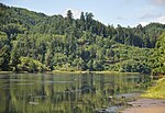
The North Umpqua River is a tributary of the Umpqua River, about 106 miles (171 km) long, in southwestern Oregon in the United States. It drains a scenic...
9 KB (784 words) - 17:54, 17 May 2024

The Umpqua River (/ˈʌmpkwə/ UMP-kwə) on the Pacific coast of Oregon in the United States is approximately 111 miles (179 km) long. One of the principal...
13 KB (1,111 words) - 22:37, 28 April 2023
The Little River is a tributary of the North Umpqua River, about 30 miles (48 km) long, in southwestern Oregon in the United States. It drains part of...
10 KB (1,021 words) - 09:40, 10 May 2020

The South Umpqua River is a tributary of the Umpqua River, approximately 115 miles (185 km) long, in southwestern Oregon in the United States. It drains...
9 KB (779 words) - 03:03, 11 May 2020

The North Umpqua Hydroelectric Project is a series of hydroelectric power generation facilities along the North Umpqua River in Douglas County, Oregon...
5 KB (397 words) - 11:35, 22 May 2024
sixteen campus buildings located on 100 acres (40 ha) bordering the North Umpqua River. The campus also features a track, tennis courts, and an outdoor pool...
17 KB (1,566 words) - 18:13, 25 July 2024

Steamboat Creek is a short tributary of the North Umpqua River in southwestern Oregon in the United States. Approximately 35 kilometres (22 mi) long, the...
2 KB (223 words) - 06:15, 11 May 2020

Calapooya Mountains (category Umpqua National Forest)
by the Coast Fork Willamette River and its tributaries. In the southern drainage, the tributaries of the North Umpqua River have cut into the southern slopes...
7 KB (799 words) - 06:39, 17 August 2024
The Spring River is a short but significant tributary of the North Umpqua River in Douglas County in the U.S. state of Oregon. It begins at a spring complex...
5 KB (388 words) - 03:05, 11 May 2020

The North Umpqua Trail is a multi-use trail open for hiking, mountain biking and horse-back riding that follows the North Umpqua River in Southern Oregon...
3 KB (186 words) - 01:22, 20 November 2020
of the Umpqua to the south and the Siuslaw River to the north. Rising in northern Douglas County about 10 miles (16 km) north of Drain, the river flows...
7 KB (508 words) - 00:18, 10 February 2022

The Colliding Rivers is the name of the confluence of Little River into the North Umpqua River at Glide, Oregon, approximately 12 miles (19 km) east-northeast...
3 KB (282 words) - 07:09, 20 November 2023

Douglas County, Oregon, United States, on the North Umpqua River at its confluence with the Clearwater River. It is located approximately 58 miles (93 km)...
2 KB (293 words) - 11:04, 11 February 2024
The Umpqua Basin is a watershed in the U.S. state of Oregon. It includes the drainages of the South Umpqua River, North Umpqua River, mainstem Umpqua River...
1 KB (92 words) - 10:46, 31 May 2021

known as the Umpqua Valley. At least four tribal groups have historically lived in the Umpqua River Basin: the Southern Molalla, the Lower Umpqua tribe, the...
10 KB (1,110 words) - 19:52, 29 May 2024

the south bank of the North Umpqua River 4 miles (6.4 km) north of Roseburg on Interstate 5 and is included in the Roseburg North CDP for statistical purposes...
9 KB (434 words) - 21:01, 15 September 2024

River North Fork Umatilla River North Powder River North Santiam River North Umpqua River North Yamhill River Owyhee River Pistol River Powder River Pudding...
97 KB (11,400 words) - 16:41, 4 August 2024

ranger districts for the forest are the Cottage Grove, Diamond Lake, North Umpqua, and Tiller ranger districts. The forest is managed by the United States...
9 KB (880 words) - 01:05, 8 October 2024
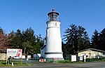
The Umpqua River Light is a lighthouse on the Oregon Coast of the United States, located at the mouth of the Umpqua River on Winchester Bay, in Douglas...
7 KB (538 words) - 06:25, 19 November 2023

The Umpqua River Bridge is a swing-span bridge that spans the Umpqua River in Reedsport, Oregon. It consists of a central swing span flanked by two reinforced...
5 KB (411 words) - 20:25, 11 January 2024

The Umpqua Hot Springs are a group of geothermal springs located along the North Umpqua River in the U.S. state of Oregon at 2,640 feet (800 m) elevation...
4 KB (423 words) - 20:43, 15 January 2024

Diamond Lake (Oregon) (category Umpqua National Forest)
The outlet of the lake is at its north end. From there, water flows via Diamond Lake Creek into the North Umpqua River and ultimately to the Pacific Ocean...
11 KB (1,101 words) - 14:13, 30 January 2024

Maidu Lake (category Umpqua National Forest)
is the source of the North Umpqua River. The eastern terminus of the 79-mile (127 km) North Umpqua Trail, which follows the river, is at Maidu Lake. A...
3 KB (244 words) - 14:52, 25 September 2020

takes its name from Cow Creek, a tributary of the South Umpqua River. The Cow Creek Band of Umpqua Tribe of Indians > In actuality several different tribal...
7 KB (813 words) - 09:51, 26 September 2024
to meet the larger river 16 miles (26 km) from its confluence with the Umpqua River at Reedsport. The entire course of the North Fork lies within the...
6 KB (430 words) - 15:22, 12 June 2020
Limpy Creek (category Oregon river stubs)
Limpy Creek is a tributary of the North Umpqua River in Douglas County, in the U.S. state of Oregon. Limpy Creek was named for a local Native American...
3 KB (175 words) - 22:20, 19 January 2022
Legislature embracing the lands along the Umpqua River in southwestern Oregon. Gold had been discovered in the Umpqua region, which brought a rapid increase...
3 KB (235 words) - 08:00, 7 November 2023
Washington North Laramie River - Wyoming North Platte River - Colorado, Wyoming, Nebraska North Santiam River - Oregon North Umpqua River - Oregon North Yamhill...
7 KB (650 words) - 15:52, 2 May 2024

the North Umpqua River in Douglas County, Oregon, United States. The bridge provides access from Oregon Route 138 to the Mott Trailhead on the North Umpqua...
3 KB (225 words) - 20:03, 1 September 2024
(Pemigewasset River tributary), New Hampshire Smith River (Umpqua River tributary), Oregon Smith River (McKenzie River tributary), Oregon Smith River (Virginia)...
780 bytes (127 words) - 18:16, 25 May 2021