
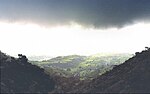
The Satpura Range is a range of hills in central India. The range rises in eastern Gujarat running east through the border of Maharashtra and Madhya Pradesh...
20 KB (2,669 words) - 06:25, 7 September 2024
systems in central India, including the one that is now known as the Satpura Range. Today, the term principally refers to the escarpment and its hilly...
24 KB (2,482 words) - 06:19, 7 September 2024

Pradesh in India. Its name is derived from the Satpura range. It covers an area of 524 km2 (202 sq mi). Satpura National Park, along with the adjoining Bori...
11 KB (1,252 words) - 04:54, 18 June 2024

municipality is located in a valley of the Satpura Range and is widely known as Satpura ki Rani. ("Queen of Satpura") Pachmarhi has an altitude of 1067. Dhupgarh...
18 KB (1,678 words) - 11:07, 15 July 2024
The Tawa River is the longest tributary of the Narmada, rising in the Satpura Range to the south and flowing north to meet the Narmada at the village of...
13 KB (879 words) - 15:40, 2 June 2024
rivers in India that flows in a rift valley, bordered by the Satpura and Vindhya ranges. As a rift valley river, the Narmada does not form a delta; Rift...
48 KB (5,438 words) - 03:16, 14 August 2024
Reserve is a non-use conservation area and biosphere reserve in the Satpura Range of Madhya Pradesh state in Central India. The conservation area was...
5 KB (422 words) - 16:20, 12 March 2024

is a major river in Vidarbha, Maharashtra, which originates in the Satpura Range and flows into the Wain ganga river to form the Pranhita river which...
4 KB (315 words) - 07:26, 20 September 2023

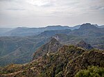
Dhupgarh or Mount Dhoopgarh is the highest point in the Mahadeo Hills (Satpura Range), Madhya Pradesh, India. Located in Pachmarhi in Hoshangabad district...
2 KB (88 words) - 13:37, 25 January 2024

constitute the primary languages of the southern Aravalli Range in Rajasthan and the western Satpura Range in Madhya Pradesh, northwestern Maharashtra, and southern...
5 KB (425 words) - 06:00, 19 May 2024
state in central India. Vindhyachal is on its northern border and the Satpura range extends along its entire length on the southern border. In the northern...
18 KB (1,915 words) - 01:03, 31 August 2024

Western Ghats (redirect from Western Ghat mountain range)
steeper western slopes facing the sea. The Western Ghats extend from the Satpura Range south of the Tapti River in the north and runs approximately 1,600 km...
51 KB (4,904 words) - 01:53, 29 August 2024

sections of its distribution in the Western Ghats, Eastern Ghats and Satpura Range as far north as Madhya Pradesh (approximately 22° N). It is found at...
18 KB (1,795 words) - 14:44, 18 March 2024

Constituency. Pipariya is located on 22.75°N 78.34°E. It is situated in Satpura range. Pipariya is 70 km from district headquarter Hoshangabad, while the...
6 KB (387 words) - 10:15, 12 August 2024
(249 sq mi), located in the northern foothills of the Satpura Range. It is bounded by the Satpura National Park to the north and east, and by the Tawa...
3 KB (198 words) - 06:39, 2 July 2024

northwest of the range, and the Bundelkhand segment to the southeast. Vindhya range, lies north of Satpura range and east of Aravali range, runs across most...
84 KB (9,215 words) - 12:07, 5 August 2024

INS Satpura (F48) is a Shivalik-class stealth multi-role frigate built for the Indian Navy. This class is an improvement over the preceding Talwar-class...
13 KB (547 words) - 12:03, 29 August 2024

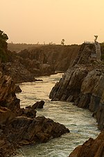
natural heritage area and is the meeting point of the Vindhya and the Satpura Ranges, with the Maikal Hills being the fulcrum. This is where the Narmada...
11 KB (908 words) - 06:37, 7 September 2024
source for the Muktainagar, Malkapur region. It rises in the eastern Satpura Range of southern Madhya Pradesh, and flows westward, draining Maharashtra's...
6 KB (429 words) - 08:55, 14 November 2023

Tawa is the Narmada's largest tributary, at 172 km. It rises in the Satpura Range of Betul and flowing north and west, joins the Narmada at the village...
3 KB (151 words) - 14:55, 11 July 2024

was formed on 1 November 1956. It is on the southwest region of the Satpura Range. It is spread from 21.28 to 22.49 deg. North (latitude) and 78.40 to...
25 KB (2,649 words) - 07:49, 25 August 2024

Marble Rocks Pachmarhi Biosphere Reserve Patalpani waterfall Satpura National Park Satpura Range Riparian districts Cities Ankleshwar Betul Bharuch Jabalpur...
3 KB (275 words) - 15:54, 24 August 2024

that is in Madhya Pradesh is nestled in the southern slopes of the Satpura range of Central India. Pench Tiger Reserve comprises the Indira Priyadarshini...
26 KB (3,239 words) - 11:51, 7 April 2024
Dhupgarh Satpura Range 1,352 4,435 22°26′56″N 78°22′16″E / 22.449°N 78.371°E / 22.449; 78.371 Dhupgarh is the highest peak in the Satpura Range. Chhattisgarh...
16 KB (433 words) - 06:51, 1 August 2024
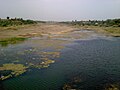
Gopalganjs Mundara Village, Seoni District, on the southern slopes of the Satpura Range of Madhya Pradesh. The river has developed extensive floodplains characterized...
10 KB (1,028 words) - 19:39, 14 July 2024

tributary of the Wainganga River draining a large area lying south of Satpura range in central India. Along its 275 km run through the Indian States of...
8 KB (710 words) - 02:33, 17 August 2024
Vidarbha region in Maharashtra, as well as the southern slopes of the Satpura Range in southeast Madhya Pradesh. It flows along the border of Gadchiroli...
7 KB (472 words) - 00:51, 3 September 2024

the Indravati into Bastar, and up the Wardha and Wainganga into the Satpura Range. The first historical reference to the Gonds appears in Muslim writings...
55 KB (6,124 words) - 19:16, 9 September 2024
of the Vindhya Range, and consists of two portions of the Narmada and Tapti river valleys, separated by a section of the Satpura Range, about 15 miles...
6 KB (726 words) - 11:15, 15 August 2024
One can reach through Shahada. It is a hill station located in the Satpura Range. Its Gorakhnath Temple is the site of a Yatra attended by thousands...
5 KB (327 words) - 07:07, 23 June 2024