
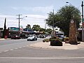
The Shire of Cobram was a local government area on the Murray River in the Goulburn Valley region, about 240 kilometres (149 mi) north of Melbourne, the...
4 KB (320 words) - 11:33, 12 May 2023
kilometres west of Cobram East. Up until this time, the area of Cobram was part of the Echuca Shire, Cobram station was included when Yarrawonga Shire was created...
24 KB (2,509 words) - 14:50, 23 August 2024

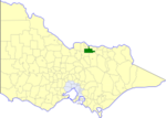
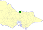
amalgamation of the Shire of Cobram, Shire of Nathalia, Shire of Numurkah, and parts of the Shire of Tungamah and Shire of Yarrawonga. The Shire is governed...
9 KB (453 words) - 18:52, 10 February 2024
Cobram East is a locality situated in the Shire of Moira, Victoria, Australia. The locality is close to the Murray River. It features a caravan park and...
4 KB (132 words) - 17:33, 8 June 2023
severed, becoming the Shire of Cobram. On 18 November 1994, the Shire of Tungamah was abolished, and along with the Shires of Cobram, Nathalia, Numurkah...
5 KB (361 words) - 11:38, 12 May 2023
Muckatah (category Shire of Moira)
of 10/- was offered to the winner. Moire Shire Council was formed in 1994 from the amalgamation of the Shire of Cobram, Shire of Nathalia, Shire of Numurkah...
8 KB (708 words) - 10:04, 7 May 2023

Barooga (category Towns in Berrigan Shire)
mainly residential area and most of its commercial and industrial needs are met in its twin town of Cobram on the south side of the Murray River. Barooga Post...
5 KB (528 words) - 14:13, 14 August 2024

Strathmerton (category Shire of Moira)
in the Shire of Moira local government area on the Murray Valley Highway and Goulburn Valley Highway, about 11 kilometres (7 mi) west of Cobram. At the...
6 KB (411 words) - 23:04, 3 July 2023

Shires of Cobram, Nathalia, Tungamah and Yarrawonga, was merged into the newly created Shire of Moira. Numurkah was divided into four ridings, each of which...
5 KB (387 words) - 11:36, 12 May 2023

the Cobram service. By 1977/78, the service between Cobram and Tocumwal was being operated by a VicRail-owned station wagon, driven by the Cobram station...
10 KB (1,012 words) - 05:15, 12 March 2024
Shire of Nathalia was abolished, and along with the Shires of Cobram, Numurkah, Tungamah and Yarrawonga, was merged into the newly created Shire of Moira...
5 KB (420 words) - 11:36, 12 May 2023

Shire of Yarrawonga was abolished, and along with the Shires of Cobram, Nathalia, Numurkah and Tungamah, was merged into the newly created Shire of Moira...
5 KB (348 words) - 11:38, 12 May 2023
Tocumwal railway line, Victoria (category Public transport routes in the City of Melbourne (LGA))
carriages 3AS – 31BE – 2AE – 22CE. Before this time the Strathmerton – Cobram section was operated as the 'branch line' with a 102hp Walker railmotor...
17 KB (1,275 words) - 00:46, 9 June 2024

Old Cobram-Barooga Bridge is a heritage-listed former road bridge and now footbridge over the Murray River at Barooga-Cobram Road, Barooga, New South Wales...
29 KB (4,147 words) - 09:10, 7 May 2023

Burramine East, Burramine North) • Burramine South (1882–1947) • Cobram (Boomerang) • Cobram East • Drumanure (1882–1856 see Invergordon) • Esmond (1893–1929)...
136 KB (12,146 words) - 05:09, 28 June 2024
Shire Advocate (Vic). 2 May 1939. p. 5. Retrieved 26 February 2024. "1940 – Girgarre Club Re-Forms". Kyabram Free Press and Rodney and Deakin Shire Advocate...
282 KB (442 words) - 02:07, 4 September 2024

The Shire of Metcalfe was a local government area about 105 kilometres (65 mi) north-northwest of Melbourne, the state capital of Victoria, Australia...
5 KB (339 words) - 21:08, 7 December 2023
Camperdown Chronicle Casterton News Castlemaine Mail The Chronicle (Wangaratta) Cobram Courier Cohuna Farmer's Weekly Colac Herald Corryong Courier Country News...
22 KB (1,505 words) - 13:04, 3 September 2024

142.70 The Shire of Dunmunkle was a local government area about 160 kilometres (99 mi) west of Bendigo and 50 kilometres (31 mi) east of Horsham, in...
4 KB (310 words) - 11:33, 12 May 2023

Yarroweyah (category Shire of Moira)
the Shire of Moira local government area, 251 kilometres (156 mi) north of the state capital, Melbourne and 10 kilometres (6 mi) west of Cobram. The...
4 KB (316 words) - 10:21, 7 May 2023

The Shire of Kilmore was a local government area about 60 kilometres (37 mi) north of Melbourne, the state capital of Victoria, Australia. The shire covered...
4 KB (265 words) - 11:35, 12 May 2023

The Shire of Rodney was a local government area in the Goulburn Valley region, about 170 kilometres (106 mi) north of Melbourne, the state capital of Victoria...
5 KB (385 words) - 11:37, 12 May 2023

The Shire of Kaniva was a local government area in the Wimmera region of western Victoria, Australia, near the South Australian town of Bordertown. The...
4 KB (273 words) - 11:34, 12 May 2023

Koonoomoo (category Shire of Moira)
Australian trend to build large roadside attractions. Also it is home to the Cobram State Forest which attracts many visitors.[citation needed] Koonoomoo had...
5 KB (200 words) - 09:58, 7 May 2023

The Shire of Myrtleford was a local government area about 280 kilometres (174 mi) northeast of Melbourne, the state capital of Victoria, Australia. The...
3 KB (207 words) - 11:36, 12 May 2023

The Shire of Mildura was a local government area located at the northwestern corner of Victoria, Australia, on the Murray River and the South Australian...
5 KB (338 words) - 11:35, 12 May 2023

The Shire of Corio was a local government area located between Geelong and Werribee, about 60 kilometres (37 mi) southwest of Melbourne, the state capital...
4 KB (264 words) - 11:33, 12 May 2023

The Shire of Walpeup was a local government area in northwestern Victoria, Australia, along the South Australian border. The shire covered an area of 10...
4 KB (239 words) - 11:38, 12 May 2023

Shepparton (redirect from History of Shepparton)
turn of the century Shepparton was central to a large network of regional branch lines on the Toolamba–Echuca railway line — lines leading to Cobram, Nathalia...
49 KB (5,073 words) - 15:41, 4 September 2024
Katamatite East (category Shire of Moira)
local government area of the Shire of Moira. Cobram East borders the north of the locality, Katamatite borders the west and south of the locality, and Boosey...
3 KB (89 words) - 09:56, 7 May 2023