
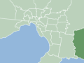
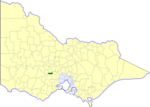
The Shire of Narracan was a local government area about 120 kilometres (75 mi) east-southeast of Melbourne, the state capital of Victoria, Australia. The...
5 KB (467 words) - 01:44, 14 June 2023

amalgamation of the Shire of Buln Buln, Shire of Narracan, Rural City of Warragul, and some parts of the Shire of Upper Yarra. The shire is governed and administered...
16 KB (824 words) - 15:26, 27 July 2024

amalgamation of the City of Moe, City of Morwell, City of Traralgon, Shire of Traralgon, and parts of the Shire of Narracan and Shire of Rosedale. The...
13 KB (768 words) - 06:08, 8 March 2024

Moe, Victoria (category City of Latrobe)
Narracan Creek was a stopover en route to the Walhalla goldfields further north. A Post Office opened on 17 March 1862. In 1878 the Shire of Narracan...
23 KB (2,586 words) - 03:24, 28 July 2024

Walhalla, Victoria (category Shire of Baw Baw)
incorporated into the neighbouring Shire of Narracan in 1918. One of the railway's main uses became the removal of old buildings out of town, with the original railway...
34 KB (4,790 words) - 15:21, 28 July 2024
Murchison Advertiser Myrtleford Mail and Whorouly Witness Nagambie Times Narracan Shire Advocate Nathalia Herald Nhill Free Press The McIvor Times The North...
22 KB (1,505 words) - 01:04, 22 September 2024

Shires of Buln Buln and Narracan, and parts of the Shire of Upper Yarra, was merged into the newly created Shire of Baw Baw. The Rural City of Warragul...
4 KB (280 words) - 11:38, 12 May 2023
morning. Moe won the Narracan Shire Football Association premiership in 1912. At the club’s 1914 AGM, the club adopted the colors of maroon guernsey and...
16 KB (1,564 words) - 15:29, 6 April 2024

covered an area of 1,245.79 square kilometres (481.0 sq mi), and existed from 1888 until 1994. Initially part of the Shire of Narracan, Woorayl was first...
4 KB (292 words) - 11:38, 12 May 2023

an area of 47 square kilometres (18.1 sq mi), and existed from 1955 until 1994. Moe was, for most of its history, part of the Shire of Narracan, which...
3 KB (287 words) - 11:35, 12 May 2023

The electoral district of Narracan is an electoral district of the Victorian Legislative Assembly in Australia. It was first proclaimed in 1967 and has...
4 KB (148 words) - 07:25, 25 May 2024

December 1994, the Shire of Buln Buln was abolished, and along with the Rural City of Warragul, the Shire of Narracan, and parts of the Shire of Upper Yarra...
4 KB (356 words) - 11:33, 12 May 2023
Tynong, Victoria (category Shire of Cardinia)
south-east of Melbourne's Central Business District, located within the Shire of Cardinia local government area. Tynong recorded a population of 523 at the...
3 KB (134 words) - 10:16, 7 May 2023

Ridings of the Shire of Narracan, and the East Riding of the Shire of Woorayl, on 13 April 1894. It annexed parts of the Boolarra and Yinnar Ridings of the...
4 KB (270 words) - 11:35, 12 May 2023

the City of Morwell was abolished, and along with the Cities of Moe and Traralgon, the Shire of Traralgon, and parts of the Shires of Narracan and Rosedale...
5 KB (360 words) - 11:36, 12 May 2023
The Shire of Cardinia is a local government area in Victoria, Australia, in the south-east of Melbourne between Western Port and the Yarra Ranges on the...
11 KB (658 words) - 00:23, 23 September 2024

December 1994, the Shire of Traralgon was abolished, and along with the Cities of Moe, Morwell and Traralgon, and parts of the Shires of Narracan and Rosedale...
4 KB (276 words) - 11:37, 12 May 2023

Gippsland (redirect from Natural resources of Gippsland)
districts of Bass, Narracan, Morwell, Gippsland South and Gippsland East lay entirely or partly in the Gippsland region. Bass is held by Labor, Narracan is held...
19 KB (1,900 words) - 15:53, 3 October 2024

• Mountain View (1901–1959 Triholm) • Narracan (1877–1974 Narracan Railway Township, Narracan East, Narracan South) • Nayook (1953–1976) • Neerim •...
136 KB (12,146 words) - 05:09, 28 June 2024
and Buln Buln and Narracan Shire Advocate (Warragul, Vic). 15 August 1890. p. 3. Retrieved 16 January 2021. "1891 - Presentation of Challenge Cup". Trove...
26 KB (1,657 words) - 15:32, 3 August 2024

Victorian Railways K class (category Preserved steam locomotives of Australia)
the Victorian Railways; the Shire of Narracan had selected that engine specifically, believing it to have spent a majority of its life in the region though...
31 KB (3,616 words) - 08:53, 19 September 2024

Thorpdale, Victoria (category Shire of Baw Baw)
selection began at Narracan (near the eastern end of the track) in 1873, and progressed steadily along the track, reaching Narracan West in 1876. A Post...
6 KB (595 words) - 22:38, 9 April 2024

Shire of Euroa was a local government area about 145 kilometres (90 mi) northeast of Melbourne, the state capital of Victoria, Australia. The shire covered...
4 KB (303 words) - 11:34, 12 May 2023

The Shire of Heytesbury was a local government area about 200 kilometres (124 mi) west-southwest of Melbourne, the state capital of Victoria, Australia...
4 KB (340 words) - 13:23, 17 December 2023

The Shire of Tallangatta was a local government area about 340 kilometres (211 mi) northeast of Melbourne, the state capital of Victoria, Australia. The...
4 KB (250 words) - 12:57, 13 September 2023

The Shire of Waranga was a local government area about 165 kilometres (103 mi) north of Melbourne, the state capital of Victoria, Australia. The shire covered...
4 KB (300 words) - 11:38, 12 May 2023

The Shire of Pyalong was a local government area about 85 kilometres (53 mi) north of Melbourne, the state capital of Victoria, Australia. The shire covered...
3 KB (225 words) - 11:36, 12 May 2023

The Shire of Barrabool was a local government area about 100 kilometres (62 mi) southwest of Melbourne, the state capital of Victoria, Australia. The shire...
4 KB (311 words) - 11:32, 12 May 2023
The Shire of Bungaree was a local government area northeast of the regional city of Ballarat, Victoria, Australia. The shire covered an area of 228 square...
3 KB (222 words) - 11:33, 12 May 2023

The Shire of Kerang was a local government area located in northwestern Victoria, Australia, along the Murray River. The shire covered an area of 3,254...
5 KB (371 words) - 11:35, 12 May 2023