
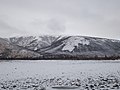
Suntar-Khayata Range (Russian: Сунтар-Хаята, Yakut: Сунтаар Хайата) is a granite mountain range rising along the border of the Sakha Republic in the north...
7 KB (623 words) - 16:51, 26 July 2024

Verkhoyansk Range-Suntar-Khayata Range – 1,650 km (1,030 mi) (section of the East Siberian System of mountains) Verkhoyansk Range – 1,100 km (680 mi) Suntar-Khayata...
51 KB (4,774 words) - 18:16, 20 September 2024

Verkhoyansk Range has a higher southeastern prolongation than the Suntar-Khayata Range, which is occasionally considered as a separate range system. Thus...
10 KB (976 words) - 16:17, 4 May 2024
East Siberian Mountains (section Ranges)
Skalisty Range Ulakhan-Bom Kyllakh Range Suntar-Khayata Range Yana-Oymyakon Highlands Elgi Plateau Oymyakon Plateau Yana Plateau Nelgesin Range Tirekhtyakh...
7 KB (595 words) - 00:14, 23 January 2024
Mus-Khaya Mountain (category Suntar-Khayata)
mountain in Sakha Republic, Russia and the highest point of the Suntar-Khayata Range with an elevation of 2,959 m (9,708 ft). The mountain is located...
2 KB (107 words) - 11:08, 21 May 2022
the Siberian tigers. The hiking and ski routes in the mountains: Badzhal Range (here more than twenty peaks exceed the height of 2000 m), Sikhote-Alin...
5 KB (554 words) - 04:37, 12 July 2024
Mount Khakandya (category Suntar-Khayata)
Mount Khakandya (Russian: Гора Хакандя) is a peak in the Suntar-Khayata Range, East Siberian System, Russia. Administratively it is located in the Khabarovsk...
2 KB (62 words) - 02:47, 28 November 2023
Berill Mountain (category Suntar-Khayata)
Berill (Russian: Берилл) is a peak in the Suntar-Khayata Range. The elevation above sea level of the mountain is 2,933 m. It is the highest point of Khabarovsk...
2 KB (82 words) - 00:48, 6 October 2023

Even word окат (okat) meaning "river". The Okhota begins in the Suntar-Khayata Range at about 1,200 metres (3,900 ft) above sea level at the junction...
4 KB (446 words) - 15:56, 22 September 2024
2012-04-20. Retrieved 2010-06-19. See Response of glaciers in the Suntar-Khayata Range, eastern Siberia Simon Denyer; Chris Mooney (November 12, 2019)....
10 KB (1,226 words) - 19:29, 18 December 2023

Yudoma (category Suntar-Khayata)
Okhotsk Coast. Its northern headwaters are in the Suntar-Khayata Range. To the east is the Yudoma Range and then the Okhota, to the south the Maya and to...
5 KB (613 words) - 10:30, 5 December 2023

with the Suntar-Khayata Range. In the southern part the Eastern Khandyga and the Tyry, also tributaries of the Aldan, cut across the range dividing into...
4 KB (410 words) - 04:33, 6 May 2024

Mountains, the Kondyor Massif, as well as a small section of the Suntar-Khayata Range, the Yudoma-Maya Highlands, and the Sette-Daban in the western border...
40 KB (3,136 words) - 06:46, 25 September 2024

Tyry (category Suntar-Khayata)
fishing. The Tyry has its sources in the southern slopes of the Suntar-Khayata Range. In the upper section of its course the river flows through a narrow...
4 KB (395 words) - 16:50, 28 March 2024
Smithsonian Institution. "Bezymianny Volcano". PeakVisor. Bolshoi Sayan Range High Point, Russia at Peakbagger.com "N-47". Topographic USSR Chart (in...
119 KB (2,491 words) - 11:16, 16 July 2024

Eastern Khandyga (category Suntar-Khayata)
in the western section of the Suntar-Khayata Range. The river heads roughly westwards and cuts across the Skalisty Range and the Sette Daban. After the...
5 KB (466 words) - 16:57, 28 July 2024
also a Suntar Khayata mountain range on the Kolyma Highway. Airport information for UENS at Great Circle Mapper. Airport information for Suntar Airport...
2 KB (104 words) - 00:45, 7 July 2024
Its population as of the 2002 Census was 46. It is located in the Suntar Khayata Range area. The R504 Kolyma Highway passes through the village. Registry...
3 KB (329 words) - 16:20, 14 February 2024
long Right Yana, which has its source in the eastern end of the Suntar-Khayata Range, the total length is 216 kilometres (134 mi). The shorter Left Yana...
4 KB (277 words) - 16:13, 16 March 2022

Retreat of glaciers since 1850 (category Climate by mountain range)
Mountains, Verkhoyansk Range, Cherskiy Range and Suntar-Khayata Range, plus possibly a few very small glaciers in the ranges near Lake Baikal, which...
140 KB (16,336 words) - 01:36, 27 September 2024

nearly 2,200 m (7,200 ft) in the Suntar Khayata Range. It heads roughly southwards below the slopes of the Kukhtuy Range rising to the west. In its last...
3 KB (245 words) - 10:59, 20 July 2024
803 ft) Irkutsk Oblast Kodar Range, Stanovoy Highlands Berill Берилл 2,934 metres (9,626 ft) Khabarovsk Krai Suntar-Khayata Range Grandiozny Peak Пик Грандиозный...
13 KB (169 words) - 15:17, 30 June 2024

inhabitants in 2021. The source of the river is in the eastern part of the Suntar Khayata Range, in Khabarovsk Krai. The river flows roughly northeastwards across...
4 KB (349 words) - 17:14, 10 April 2024

Yana-Oymyakon Highlands (category Mountain ranges of Magadan Oblast)
southern reaches of the Verkhoyansk Range to the west, the Suntar-Khayata Range to the southwest and the Chersky mountain range to the northeast. The main highland...
5 KB (422 words) - 13:47, 12 May 2023
617 m (5,305 ft) in the Suntar-Khayata range. It flows relatively straight southwards through a mountainous area. The Yudoma Range rises on the right side...
3 KB (254 words) - 04:17, 4 May 2023
Tas-Kystabyt (redirect from Sarychev Range)
Highlands and to the south it overlaps with the Suntar Khayata Range. The lower slopes of the range are covered by sparse larch taiga. The higher elevations...
3 KB (232 words) - 13:41, 22 July 2024

(Хэл-Дэги) lake, part of a lake system of the eastern end of the Suntar-Khayata range. The Inya flows roughly southwards across mountainous terrain with...
4 KB (289 words) - 03:55, 4 May 2023
Elgi Plateau (category Mountain ranges of the Sakha Republic)
the Verkhoyansk Range to the west and the Chersky Range to the northeast, the Yana Plateau to the northwest, the Suntar-Khayata Range to the southwest...
3 KB (264 words) - 16:27, 8 May 2023

Range in the central area, the Oymyakon Highlands and the Elgin Plateau in the west, the Suntar-Khayata Range at the southwestern end and some ranges...
9 KB (1,164 words) - 08:46, 22 December 2023
Southwards it is only found in mountainous areas such as in the Suntar-Khayata Range (eastern Yakutia), the mountains of southern Yakutia and southwest...
27 KB (2,808 words) - 10:48, 11 December 2023