The Umatilla National Forest, in the Blue Mountains of northeast Oregon and southeast Washington, covers an area of 1.4 million acres (5,700 km2). In descending...
8 KB (655 words) - 16:57, 15 June 2022

(west) Cold Springs National Wildlife Refuge McKay Creek National Wildlife Refuge Umatilla National Forest (part) Whitman National Forest (part) As of the...
21 KB (1,673 words) - 16:42, 24 June 2024

after the tribe, such as the Umatilla River, Umatilla County, the town of Umatilla, Florida, and Umatilla National Forest. The impoundment of the Columbia...
6 KB (553 words) - 23:06, 18 September 2023

Blue Mountains (Pacific Northwest) (category Umatilla National Forest)
the range is included in the Malheur National Forest, Umatilla National Forest, and Wallowa–Whitman National Forest. Several wilderness areas encompass...
15 KB (1,444 words) - 21:55, 3 April 2024

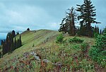
The North Fork Umatilla Wilderness is a wilderness area located inside the Umatilla National Forest, in the Blue Mountains of northeastern Oregon. It is...
4 KB (269 words) - 05:27, 28 October 2023
October 21, 2012. "Umatilla National Forest". U.S. Forest Service. Retrieved October 21, 2012. "Umpqua National Forest". U.S. Forest Service. Retrieved...
116 KB (2,714 words) - 14:10, 30 January 2024

located on U.S. Route 395 within the Umatilla National Forest about 17 miles south of Ukiah. It is near the Umatilla-Grant County border just south of the...
4 KB (398 words) - 04:10, 24 July 2023

Jubilee Lake (category Umatilla National Forest)
Jubilee Lake is a 92.33-acre (37.36 ha) man-made lake in the Umatilla National Forest in the northern corner of Union County in the U.S. state of Oregon...
6 KB (422 words) - 16:41, 28 November 2023
Fork Umatilla River is a tributary of the Umatilla River in Umatilla County in the U.S. state of Oregon. Its headwaters lie in the Umatilla National Forest...
4 KB (236 words) - 03:02, 11 May 2020

the Umatilla National Forest in the Blue Mountains of northeastern Oregon. It flows generally northwest to meet the South Fork Umatilla River near Graves...
6 KB (454 words) - 20:07, 10 May 2020

known as the Gateway to the Ocala National Forest, located in northern Lake County. The city was named after Umatilla, Oregon. In 1998 it was the site...
14 KB (901 words) - 14:15, 30 December 2023

Whitman national forests in 1954, it is located in the northeastern corner of the state, in Wallowa, Baker, Union, Grant, and Umatilla counties in Oregon...
18 KB (1,800 words) - 03:53, 12 June 2022

right by its largest tributary, the Wallowa River. Entering the Umatilla National Forest, it turns east, receiving Bear and Elbow Creeks from the left and...
81 KB (9,147 words) - 16:37, 5 May 2024

North Fork John Day Wilderness (category Umatilla National Forest)
John Day Wilderness is a wilderness area within the Umatilla and Wallowa–Whitman National Forests in the Blue Mountains of northeastern Oregon. The wilderness...
7 KB (727 words) - 00:36, 1 November 2021
Mountains at the confluence of its north and south forks in the Umatilla National Forest of northeastern Oregon. Flowing generally west, the river receives...
10 KB (824 words) - 19:43, 4 November 2023

Langdon Lake (category Umatilla National Forest)
Langdon Lake is reservoir located in the Umatilla National Forest of Northeastern Oregon, United States. It is an impoundment of Morning Creek, and the...
2 KB (116 words) - 14:34, 25 September 2020

meanings throughout the world. See old-growth forest for more information.) In Australia, the 1992 National Forest Policy Statement (NFPS) made specific provision...
86 KB (1,718 words) - 04:30, 3 July 2024
Kaniksu National Forest Mount Baker–Snoqualmie National Forest Okanogan–Wenatchee National Forest Olympic National Forest Umatilla National Forest Note:...
5 KB (407 words) - 19:01, 19 July 2023

Meacham, Oregon (category Unincorporated communities in Umatilla County, Oregon)
community in Umatilla County, Oregon. It is located on the old alignment of U.S. Route 30 off Interstate 84, in the Umatilla National Forest, near Emigrant...
13 KB (577 words) - 11:12, 13 December 2023

narrow band along the northern edge of the Umatilla National Forest, mostly outside the national forest's boundaries. Ecoregions defined by the EPA and...
19 KB (2,076 words) - 05:12, 28 February 2023

1995. p. 2. Umatilla National Forest (N.F.), Rimrock Ecosystem Restoration Projects: Environmental Impact Statement. United States Forest Service. 2003...
4 KB (333 words) - 15:55, 2 July 2024

local ranger district offices located in Silver Springs and Umatilla. The Ocala National Forest lies between the Ocklawaha and St. Johns rivers in North...
22 KB (2,672 words) - 23:02, 9 May 2024

Spout Springs Ski Area (category Umatilla National Forest)
It is in the Blue Mountains of northeastern Oregon, within the Umatilla National Forest. There is a variety of terrain for both the beginner and intermediate...
9 KB (1,119 words) - 00:29, 23 February 2024
Wenaha–Tucannon Wilderness (category Umatilla National Forest)
Wilderness Act of 1978 and encompasses 177,423 acres (71,801 ha) in the Umatilla National Forest — 66,375 acres (26,861 ha) in Oregon and 111,048 acres (44,940 ha)...
5 KB (411 words) - 00:15, 24 August 2022

Colville National Forest Idaho Panhandle National Forest (partial) Kaniksu National Forest (partial) Okanogan–Wenatchee National Forest Umatilla National Forest...
18 KB (999 words) - 02:57, 26 May 2024

Umatilla County - east Benton County, Washington - north Klickitat County, Washington - northwest Umatilla National Forest (part) Umatilla National Wildlife...
20 KB (1,841 words) - 18:44, 26 April 2024

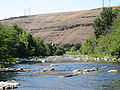
John Day River (category Umatilla National Forest)
bears his name, forcing them to hike 80 miles (130 km) back to friendly Umatilla Indians under extreme conditions. The absence of dams on the river causes...
12 KB (1,087 words) - 12:14, 4 December 2023

(southwest) Umatilla County (west) Nez Perce National Historical Park (part) Umatilla National Forest (part) Wallowa–Whitman National Forest (part) Hells...
26 KB (2,369 words) - 18:45, 26 April 2024

east Umatilla County, Oregon - south Benton County - west Franklin County - northwest McNary National Wildlife Refuge Umatilla National Forest (part)...
17 KB (1,361 words) - 08:07, 22 July 2024
States. It is located in the North Fork John Day Wilderness of the Umatilla National Forest. List of mountain peaks of Oregon U.S. Geological Survey Geographic...
2 KB (62 words) - 10:44, 5 January 2019