
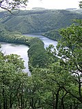
Urft in the district of Euskirchen to create the Urft Reservoir (Urftstausee), 2.16 km2 in area. The reservoir is also called the Urftsee (Lake Urft)...
14 KB (991 words) - 05:15, 16 April 2024

Kall, North Rhine-Westphalia (redirect from Urft)
Scheven, Sistig, Sötenich, Steinfeld, Steinfelderheistert, Straßbüsch, Urft, Wahlen, Wallenthal, Wallenthalerhöhe, and Kall itself. Wahl des/der Bürgermeisters/in...
2 KB (129 words) - 19:32, 21 November 2022

the village of Urft in the municipality of Kall. The Urft rises in the North Eifel region of the Eifel Mountains. The name of the Urft is derived from...
14 KB (686 words) - 09:36, 30 January 2021
bordered to the northwest by the Rur Reservoir and includes the neighbouring Urft Reservoir, the former Vogelsang Military Training Area, but not the Nazi...
14 KB (1,786 words) - 12:13, 25 July 2023

covered the smaller region roughly around the sources of the rivers Ahr, Kyll, Urft and Erft. Its name was more recently transferred to the entire region. The...
83 KB (8,205 words) - 08:08, 20 August 2024

advanced, the Germans opened the sluice gates of upstream dams (Rur Dam and Urft Dam). This stopped the Americans from crossing as planned. It had been anticipated...
5 KB (436 words) - 12:40, 27 August 2023

to the Roer in 2004. Ellebach Inde Kall Malefinkbach Merzbach Wurm Olef Urft During the Middle Ages the valley of the Roer lay mostly within the Duchy...
7 KB (795 words) - 22:07, 24 August 2024
so-called Dreiborn Plateau. In the north and east it was bounded by the Urft Reservoir. The training area had an area of around 45 km2 and since 1 January...
10 KB (1,129 words) - 18:59, 9 February 2024

other, smaller, structures: the Paulushof Dam holding the Obersee and the Urft Dam holding the Urftstausee. If the floodgates were opened, the resulting...
48 KB (6,007 words) - 15:08, 26 August 2024

located immediately below the Urft Dam, which impounds the waters of the Urft that flow from the east to create the Urft Reservoir, and immediately above...
7 KB (341 words) - 18:42, 26 May 2024

Germany. It is 27.9 kilometres (17.3 mi) long and a left-hand tributary of the Urft. It flows through the Eifel Mountains in the western part of the Germany...
8 KB (745 words) - 08:38, 17 April 2024

of U-boat pens, December 1944 – April 1945 8 December, 11 December 1944 Urft Dam, (30 mi (48 km) southwest of Cologne) was attacked to prevent it being...
39 KB (4,519 words) - 17:20, 15 May 2024

by destroying the floodgates of two dams on the upper Roer (Rur Dam and Urft Dam). During the two weeks that the little river was flooded, Hitler did...
40 KB (4,905 words) - 18:09, 20 August 2024

German government did not set out building large dams such as the prewar Urft, Mohne, and Eder dams to expand hydropower: they mostly wanted to reduce...
59 KB (7,429 words) - 07:40, 27 August 2024

1516–1525 late Gothic hall church, König organ from 1770) From 1900 to 1905 the Urft Dam was built as the largest dam in Europe at the time. Today it is part...
11 KB (954 words) - 08:25, 17 July 2024

Eifel hills, approx. 20 km south-west of Euskirchen. The rivers Erft and Urft have their source in the municipality. The district of the city Netterheim...
7 KB (327 words) - 20:13, 20 June 2023
flooding by doing the same to dams further upstream on the Roer and the Urft. The river rose at two feet an hour and the valley downstream to the Maas...
28 KB (3,347 words) - 03:10, 2 June 2024

range near Jelenia Góra. Then the largest in Europe, surpassing even the Urft Dam built in 1905, it created a reservoir of about 4 km (2.5 mi) length....
7 KB (642 words) - 19:44, 11 May 2024

than the Rhine, due to the flooding threat posed by Roer dams upstream. The Urft Dam (Urfttalsperre) held 161,000,000 cubic feet (4,550,000 m3) of water,...
47 KB (4,788 words) - 04:49, 2 September 2024

– Köln Süd – Erftstadt – Weilerswist – Euskirchen – Mechernich – Kall – Urft (Steinfeld) – Nettersheim – Blankenheim (Wald) – Schmidtheim – Dahlem (Eifel)...
14 KB (1,280 words) - 23:00, 13 August 2024

valley of the Reifferscheider Bach via Steinfeld into the valley of the River Urft. Roland Günter (1989), Kunstreiseführer Rheinland (in German), Bintlach:...
3 KB (267 words) - 10:58, 9 February 2022

well known Kneipp resort. In Gemünd the Olef has its mouth on the River Urft; hence the origin of the name of the village (Mund = [river] mouth). On the...
4 KB (382 words) - 10:05, 16 September 2021
between 500 and 692 m above sea level (NN) lie the sources of the Olef, Urft and Kyll. Its highest elevation is on the Weißer Stein (692 m; with ski slopes)...
2 KB (253 words) - 23:26, 16 October 2023

into the Urft tributary, the Olef, at about 403 m. The catchment of the Platißbachs is 38.6 km2 (14.9 sq mi) in area and drains over the Olef, Urft, Rur,...
4 KB (294 words) - 17:09, 27 March 2020

pre-basin of the Rur Dam), and in the south by the Urft Reservoir (at around 322.5 m above NN) and thus the Urft valley. In the southwest the Kermeter transitions...
6 KB (745 words) - 05:24, 15 September 2021

Aqueduct. The aqueduct began at a spring in the area of Nettersheim in the Urft river valley. It then travelled along the valley to Kall, where it had to...
22 KB (3,093 words) - 11:26, 28 February 2024
Reservoir Olef Dam Perlenbach Dam Rur Dam Sorpe Reservoir Steinbachtal Dam Urft Dam Wahnbach Dam Wehebach Dam Wupper Dam Altenberg Reservoir Bautzen Reservoir...
4 KB (429 words) - 10:33, 24 May 2024

Kuttenbach is a 5.3 kilometre-long, orographically left-hand tributary of the Urft in North Rhine-Westphalia, Germany, in the municipality of Kall. The Kuttenbach...
3 KB (215 words) - 05:27, 16 December 2019

Vogelsang with the valleys of the Neffgesbach and Morsbach, in the north by the Urft valley and the Urftsee lake, which separates the Dreiborn Plateau from the...
7 KB (943 words) - 04:48, 3 March 2021

Böttenbach, which rise north-northwest and north of the village and flow into the Urft Reservoir to the west, and the Eselsbach, which rises east of the settlement...
3 KB (305 words) - 11:37, 24 September 2021