
Vermont Route 67 (VT 67) is a 4.254-mile-long (6.846 km) east–west state highway in Bennington County, Vermont, United States. It runs from a continuation...
7 KB (409 words) - 03:14, 19 March 2023

Vermont state line in Hoosick, where it continues eastward as Vermont Route 67 (VT 67). NY 67 begins at an intersection with NY 5 east of the village of...
23 KB (1,942 words) - 02:04, 17 April 2024

line, where it becomes New York State Route 67, continuing on to North Hoosick. Vermont Route 67A intersects VT 67 in the center of North Bennington and...
13 KB (1,036 words) - 22:41, 25 July 2024
Road 67 Utah State Route 67 Vermont Route 67 Vermont Route 67A Virginia State Route 67 West Virginia Route 67 Wisconsin Highway 67 A67 (disambiguation)...
7 KB (478 words) - 16:11, 27 August 2024

Vermont Route 7A (VT 7A) is a 27.8-mile-long (44.7 km) north–south state highway in Bennington County, Vermont, in the United States. It is an alternate...
7 KB (464 words) - 20:17, 25 May 2024
7) and Vermont Route 67 intersect in the village, with VT 7A leading north to Arlington and Manchester and south into Bennington, while VT 67 leads west...
7 KB (545 words) - 04:59, 10 July 2024

Highways, and Vermont routes. Routes in Vermont are abbreviated as "VT #" by VTrans and also abbreviated as "VT Route #" and "Route #" in common usage...
62 KB (1,082 words) - 17:43, 14 August 2024

The entire route is in Chittenden County. Vermont Route 2B (VT 2B) is an alternate route of US 2 between Danville and St. Johnsbury. The route begins across...
25 KB (1,463 words) - 01:41, 5 August 2024

Vermont (/vərˈmɒnt/ vər-MONT) is a state in the New England region of the Northeastern United States. It borders Massachusetts to the south, New Hampshire...
217 KB (21,654 words) - 21:33, 29 August 2024

village of Highgate Springs, Vermont, immediately south of the Canada–United States border. US 7 in Connecticut (also known as Route 7, Ethan Allen Highway...
17 KB (1,672 words) - 23:54, 3 August 2024

(275 km) from Montpelier, Vermont, beginning at US 2, to Portland, Maine, at U.S. Route 1. It passes through the states of Vermont, New Hampshire and Maine...
25 KB (1,430 words) - 22:28, 4 August 2024

Vermont Route 11 (VT 11) is a 42.154-mile-long (67.840 km) east–west state highway in Vermont, United States. The western end of the highway is at VT...
11 KB (798 words) - 21:24, 18 October 2022

Vermont Route 103 (VT 103) is a 42.036-mile-long (67.650 km) north–south state highway in southern Vermont, United States. It runs from U.S. Route 5 (US...
8 KB (585 words) - 18:37, 23 July 2024

Interstate 91 (redirect from Interstate 91 (Vermont))
miles (89 km) in Massachusetts, and 177 miles (285 km) in Vermont. I-91 parallels US Route 5 (US 5) for all of its length, and many of the exits along...
84 KB (5,162 words) - 06:43, 7 July 2024

Vermont Route 15 (VT 15) is a 68.957-mile-long (110.976 km) east–west state highway in northern Vermont, United States. Its western terminus is at U.S...
16 KB (1,448 words) - 02:28, 19 March 2023

New York State Route 346 (NY 346) and Vermont Route 346 (VT 346) are short, adjoining state highways in the northeastern United States. Together, they...
10 KB (844 words) - 10:36, 8 January 2023

traversing Vermont. In New York, US 4 is signed north–south to reflect its alignment in the state. In Vermont and New Hampshire, the route is signed east–west...
10 KB (913 words) - 04:59, 1 August 2024

New England road marking system (redirect from New England Interstate Route 17)
then U.S. Route 4, Vermont Route 30, U.S. Route 7, U.S. Route 2, and Vermont Route 225. Route 30A was superseded by Vermont Route 22A, and Route 30B was...
158 KB (6,445 words) - 17:10, 1 February 2024
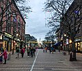
Burlington is the most populous city in the U.S. state of Vermont and the seat of Chittenden County. It is located 45 miles (72 km) south of the Canada–United...
80 KB (8,204 words) - 03:11, 28 August 2024

mont-PEEL-yər) is the capital of the U.S. state of Vermont and the county seat of Washington County. The site of Vermont's state government, it is the least populated...
43 KB (4,400 words) - 21:09, 15 August 2024

populous county in the U.S. state of Vermont. As of the 2020 census, its population was 168,323. The county seat is Vermont's most populous municipality, the...
29 KB (2,546 words) - 15:06, 26 April 2024

Jeffersonville in the town of Cambridge. Vermont Route 100C leads northeast from Johnson village 4.5 miles (7.2 km) to Vermont Route 100 in North Hyde Park. According...
12 KB (824 words) - 04:08, 11 May 2024
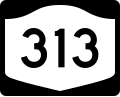
New York State Route 313 (NY 313) and Vermont Route 313 (VT 313) are a pair of like-numbered state highways in New York and Vermont in the United States...
13 KB (1,242 words) - 02:04, 3 February 2023
Champlain, and lies on the only road-based route across Lake Champlain to New York state north of Addison, Vermont. The original name of the town, "Alburgh"...
13 KB (1,151 words) - 04:29, 28 July 2024

Barre and Burlington, Vermont, with stops along the route. VTL grew to add destinations throughout the state, and added routes to Montreal, Quebec; to...
4 KB (306 words) - 04:47, 23 November 2023

Interstate 93 (redirect from Interstate 93 (Vermont))
Highway in the New England states of Massachusetts, New Hampshire, and Vermont in the United States. Spanning approximately 190 miles (310 km) along a...
77 KB (5,922 words) - 21:17, 28 July 2024

the U.S. state of Vermont. As of the 2020 census, the population was 60,572, making it the second-most populous county in Vermont. Its county seat and...
30 KB (2,991 words) - 15:07, 26 April 2024

town in Lamoille County, Vermont, United States. The population was 5,223 at the 2020 census. The town lies on Vermont Routes 108 and 100. It is nicknamed...
35 KB (3,058 words) - 19:05, 5 May 2024

Vermont Route 66 (VT 66) is a short 7.621-mile-long (12.265 km) state highway located entirely within the town of Randolph in Orange County, Vermont, United...
3 KB (192 words) - 03:14, 19 March 2023

Newport is the only city in, and the shire town of, Orleans County, Vermont, United States. As of the 2020 Census, the population was 4,455. The city...
45 KB (4,229 words) - 15:02, 24 August 2024