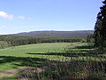
At 927 m above sea level (NN), the Bruchberg in the Upper Harz is the second highest mountain in Lower Saxony and the third highest in the Harz mountains...
5 KB (444 words) - 14:45, 20 April 2021
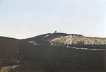
Highest point Elevation 893 m above sea level (NN) (2,930 ft) Prominence 122 m → Bruchberg Isolation 3.2 km → Achtermannshöhe Coordinates 51°44′26″N 10°32′17″E...
4 KB (266 words) - 19:17, 15 July 2021

023 m) to the southwest. Other prominent hills in the Harz are the Acker-Bruchberg ridge (927 m), the Achtermannshöhe (925 m) and the Wurmberg (971 m) near...
62 KB (8,359 words) - 01:33, 19 October 2024

In 1937 the Brocken, together with the Wurmberg, Achtermann and Acker-Bruchberg were designated as the Upper Harz (Oberharz) nature reserve. During an...
42 KB (4,915 words) - 07:12, 15 October 2024

from precipitation-heavy regions a long way away (particularly from the Bruchberg and parts of the Brocken massif). It was laid in 1732 and continually...
6 KB (826 words) - 21:38, 2 April 2022

northern rim of the Harz and is bordered in the southeast by the Acker-Bruchberg ridge beyond the Söse valley. The Upper Harz was, for centuries, dominated...
10 KB (1,370 words) - 20:15, 20 August 2024

Harz mountains in Lower Saxony (Germany). The ridge begins south of the Bruchberg near Stieglitzecke (on the B 242) and runs from there for about 13 kilometres...
7 KB (766 words) - 11:54, 24 March 2023

Dam and the Silberteich. The highest elevations are the Brocken, the Bruchberg and the Achtermann. The present, pan-state Nationalpark Harz was formed...
18 KB (2,388 words) - 13:05, 13 September 2024

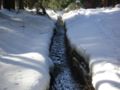
at about 910 metres in the Harz National Park in a boggy area on the Bruchberg in the Harz mountains of central Germany. This early section is known...
8 KB (847 words) - 07:48, 20 August 2024
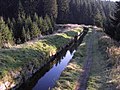
Dyke Ditch Dyke Ditch Dammgraben 1732–1827 15.409 m From the Brocken-Bruchberg area to the Upper Hausherzberg Pond Morgenbrodstal Ditch Morgenbrodstaler...
10 KB (405 words) - 20:15, 20 August 2024

Schönau) Großer Eyberg (513.0 m) Schorlenberg (402.0 m) (east of Alsenborn) Bruchberg (388.6 m) (north of Otterberg) Blättersberg (613.2 m) Bloskülb (570.2 m)...
90 KB (10,763 words) - 17:19, 7 September 2024
Mittelberg (667.1 m). Towards the southwest the countryside transitions to the Bruchberg (ca. 927 m). On the north flank of the Dehnenkopf rise two tributaries...
4 KB (367 words) - 01:40, 31 December 2021
Hexentanzplatz ("Witches' Dance Floor") in Thale and other sites such as the Bruchberg and Braunlage. The trail cannot be walked in one day, and in any case...
4 KB (542 words) - 18:29, 12 July 2020
Wernigerode and Schierke, Saxony-Anhalt Steile Wand (max. c. 780 m), on the Bruchberg, in Richtung Torfhaus, Lower Saxony Stollenklippe (max. c. 690 m), Auf...
14 KB (1,532 words) - 20:45, 19 June 2024
Kapellenklippe, Brockenkinderklippe, Zeterklippen; S: Holtemme, S: Wormke Bruchberg 9270 Upper Harz (High Harz); Harz NLP Altenau, Torfhaus UA-GS; GS LS Okerstein...
175 KB (892 words) - 00:00, 11 January 2024

the fourth highest mountain in the Harz after the Brocken, Wurmberg and Bruchberg. The condition of the route is extremely varied and changeable. For example...
8 KB (1,027 words) - 12:05, 3 May 2024

right hand tributary of the Oder. The Sieber rises at 760 metres on the Bruchberg massif and flows through Herzberg before discharging at Hattorf into the...
4 KB (291 words) - 01:28, 2 March 2021
please contribute! Wurmberg (971.2 m (3,186 ft)), Goslar district, Harz Bruchberg (927 m), Goslar district, Harz Achtermannshöhe (926 m), Goslar district...
39 KB (3,193 words) - 13:33, 10 October 2023