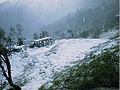
Cerro El Pital is a mountain in Central America, on the border of El Salvador and Honduras. It is located 12 km (7 mi) from the town of La Palma at a height...
4 KB (276 words) - 21:26, 11 September 2024

five in Guatemala, four in El Salvador, three in Costa Rica, three in Nicaragua, and two in Panamá. Cerro El Pital lies on the El Salvador-Honduras border...
30 KB (1,393 words) - 23:11, 17 February 2023

The Cerro Pital salamander (Bolitoglossa synoria) is a species of salamander in the family Plethodontidae. It is found in El Salvador and Honduras in the...
1 KB (83 words) - 22:14, 16 February 2024

The lowest point of elevation in El Salvador is the Pacific Ocean, at sea level. The highest point is Cerro El Pital, at 2,730 m. Maritime claims: Exclusive...
25 KB (1,912 words) - 20:23, 12 June 2024
Galápagos Islands El Salvador Cerro Cinotepeque Cerro El Pital (shared with Honduras) Guatemala Cerro Amay, in Quiché Department Cerro de Coxóm, in Totonicapán...
23 KB (2,785 words) - 01:42, 28 August 2024

Nathalie (2004). "El cerro El Pital fue cubierto por escarcha". El Salvador.com. Retrieved July 31, 2008. La Palma - Chalatenango, El Salvador Artisan...
16 KB (1,085 words) - 15:49, 20 July 2024

Ocotepeque. Passes at the highest point of the territory of El Salvador, the Cerro El Pital. The limit was first set in 1841 when the two countries were...
2 KB (171 words) - 22:38, 16 July 2024

320 km2 (123.6 sq mi) of water within El Salvador's borders. The highest point in El Salvador is Cerro El Pital, at 2,730 metres (8,957 ft), on the border...
185 KB (18,233 words) - 09:58, 11 September 2024
Guatemala, four in El Salvador, three in Costa Rica, two in Nicaragua, and one in Panamá. Cerro El Pital straddles the border between El Salvador and Honduras...
12 KB (910 words) - 21:34, 22 October 2023

Constanza1 Ecuador: Ambato1, Cuenca1, Latacunga1, Quito1, Riobamba1 El Salvador: Cerro El Pital1 Guatemala: Antigua Guatemala1, Cobán1, Fraijanes1, Quetzaltenango1...
39 KB (2,595 words) - 14:16, 28 August 2024

Chalatenango Department (category Departments of El Salvador)
over 192,000 inhabitants. Chalatenango's maximum elevation, located at Cerro El Pital (the country's highest point), is 8,960 feet (2,730 m). Amílcar Iván...
18 KB (1,773 words) - 22:11, 31 August 2024

in El Salvador, thanks to its pleasant climate and beautiful mountains. There we can find the highest mountain in the country: the "Cerro El Pital" (The...
6 KB (188 words) - 15:49, 20 July 2024

is usually defined as consisting of eight countries: Belize, Costa Rica, El Salvador, Guatemala, Honduras, Nicaragua, Mexico, and Panama. Within Central...
108 KB (7,929 words) - 14:25, 14 September 2024
Time zone: Central Standard Time (UTC-06) Extreme points of El Salvador High: Cerro El Pital 2,730 m (8,957 ft) Low: North Pacific Ocean 0 m Land boundaries:...
21 KB (1,251 words) - 13:08, 30 October 2023

godominicanrepublic.com. Retrieved 2024-09-12. CORSATUR (2022-02-14). "Cerro El Pital | El Salvador". El Salvador Travel (in Spanish). Retrieved 2024-09-12. "Gunnbjørn...
9 KB (476 words) - 15:48, 14 September 2024

Plomo Mummy (redirect from La Momia del Cerro El Plomo)
Boy of El Plomo, El Plomo Mummy, or La Momia del Cerro El Plomo in Spanish) is the well preserved remains of an Incan child found on Cerro El Plomo near...
18 KB (2,162 words) - 08:59, 13 May 2024

625 ft Qattara Depression −133 m −436 ft 2762 m 9,062 ft El Salvador America Cerro El Pital 2730 m 8,957 ft North Pacific Ocean sea level 2730 m 8,957 ft...
53 KB (2,163 words) - 20:40, 12 September 2024
Pirin Mountain, Bulgaria Mount Melbourne 2,732 8,963 Antarctica Cerro El Pital 2,730 8,957 El Salvador – Highest Mount Redoubt 2,730 8,957 Washington, US...
139 KB (176 words) - 03:23, 5 September 2024

and the Cerro Las Minas at 2,850 m (9,350 ft). The Honduran border with El Salvador crosses the peak of Cerro El Pital, the highest point in El Salvador...
42 KB (4,017 words) - 08:34, 11 September 2024
summit of Mount Odin is the highest point of Baffin Island. The summit of Cerro el Nacimiento is the highest point of Sierra Madre del Sur and Estado Libre...
197 KB (5,636 words) - 01:01, 31 August 2024
The Cerro Matoso mine in northwest of Colombia is one of the largest open-pit ferronickel mines in the world. and the largest mine of South America, containing...
16 KB (1,853 words) - 19:09, 12 September 2024
Malvín) Episode summary During the Pit Stop, teams were flown to Montevideo, Uruguay. Teams departed from Fortaleza del Cerro in groups 15 minutes apart based...
54 KB (4,973 words) - 20:32, 21 August 2024

city. The landslide acted as a natural dam along the southern slope of Cerro El Pital . Rainfall accumulated in a lake formed behind this temporary obstruction...
41 KB (4,285 words) - 07:44, 12 November 2023

Ilobasco, Suchitoto, San Sebastián, Cihuatán, Colima, La Palma, San Ignacio, El Pital, Las Pilas, Miramundo, Citalá, Iglesia del Pilar. Route of La Paz Perquín...
16 KB (1,888 words) - 05:43, 4 June 2024

Central American pine–oak forests (category Ecoregions of El Salvador)
Montecristo National Park San Isidro Natural Monument Guatemala Cerro del Baúl National Park El Pital Biological Reserve Ixil Visis-Cabá Biosphere Reserve Iximché...
11 KB (1,004 words) - 05:45, 25 May 2024

La Fortuna, San Carlos (section Cerro Chato)
the canton, just behind the districts of Quesada, Aguas Zarcas (es), and Pital. The district is covered by the following road routes: National Route 4...
12 KB (1,236 words) - 04:11, 15 April 2024

However, since 2015 the deposit has been operational again. Cerro Colorado is one of the open-pit mines that make up the Minas de Riotinto mining complex...
12 KB (1,326 words) - 00:58, 12 September 2024
subsidiary of Canadian company New Gold, announced plans to start open pit mining at Cerro San Pedro. There was major opposition to the project, but in 2007...
38 KB (3,485 words) - 00:23, 13 August 2024

Villavieja Yaguara Algarrobo Aracataca Ariguaní Cerro San Antonio Chibolo Ciénaga Concordia El Banco El Piñón El Retén Fundación Guamal Nueva Granada Pedraza...
37 KB (1,950 words) - 15:40, 5 June 2024
Cerro de San Pedro is a village and seat of the municipality of Cerro de San Pedro, located in the Mexican state of San Luis Potosí in central Mexico...
12 KB (1,457 words) - 23:41, 6 May 2024