
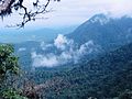
Cherrapunji (/ˌtʃɛrəˈpʌndʒi, -ˈpʊn-/ ) or Sohra is a sub-divisional town (Proposed District) East Khasi Hills district in the Indian state of Meghalaya...
19 KB (1,620 words) - 07:46, 2 July 2024
high rainfall, it has received the epithet of "The Cherrapunji of South India", after Cherrapunji, one of the rainiest places in India. Agumbe is associated...
32 KB (2,414 words) - 16:52, 14 May 2024
35′ E, at an altitude of about 1,400 meters (4,600 ft), 15 km west of Cherrapunji, in the Khasi Hills in the state of Meghalaya (India). Under the Köppen...
16 KB (1,082 words) - 21:14, 11 February 2024

nearby Cherrapunji are known to exist in and around the villages of Tynrong, Mynteng, Nongriat, Nongthymmai, and Laitkynsew. East of Cherrapunji, examples...
20 KB (1,902 words) - 10:38, 21 July 2024

long road connects Cherrapunji with Shillong. Living root bridges are also a tourist draw, with many examples located near Cherrapunji. The Double-Decker...
116 KB (12,457 words) - 21:05, 31 July 2024
Arotrophora cherrapunji is a species of moth of the family Tortricidae. It is found in Assam, India. The wingspan is about 22 mm. The species name refers...
1 KB (66 words) - 12:48, 24 February 2024

Wei Sawdong Falls is a three-tiered waterfall located in Cherrapunji, Meghalaya. The fall is situated some 60 km southwest of Shillong in East Khasi Hills...
3 KB (206 words) - 18:52, 22 January 2024

Wah Kaba Falls is a waterfall located near Cherrapunji in Meghalaya, in the north eastern India. The waterfall descends from a steep rockface and drops...
1 KB (112 words) - 14:14, 17 January 2023

unfortunate Ka Likai. Nohkalikai Falls are located on the edge of the Cherrapunji Plateau and always fed by the rain. Nohkalikai Falls depicted in a painting...
5 KB (564 words) - 05:58, 14 May 2023

can be reached via trekking 45 kilometres (28 mi), or 6500 steps, from Cherrapunji. There is also a waterfall nearby. Due to tourism, the health of the...
3 KB (263 words) - 05:22, 8 July 2024

district is known by the nicknames of Cherrapunji of Rajasthan, Nagpur of Rajasthan, Brijnagar of Rajasthan etc. Cherrapunji of rajasthan because the highest...
23 KB (2,117 words) - 17:17, 25 July 2024

Kundapur Taluk in Udupi district to show which one can be called the "Cherrapunji of South India". "DES" (PDF). DES. Archived from the original (PDF) on...
8 KB (424 words) - 08:57, 3 November 2023

Pradesh Loktak lake, Manipur Majuli Island, Assam Nohkalikai Falls, Cherrapunji, Meghalaya Kangchenjunga, the third highest mountain peak in the world...
136 KB (9,416 words) - 17:58, 3 August 2024

Nilambur on the Kerala side. Devala is receiving the highest rainfall after cherrapunji in the world. The Gudalur and Pandalur taluks of Nilgiris district one...
16 KB (1,672 words) - 17:14, 17 November 2023

Rangthylliang 1 root bridge is a living root bridge in Cherrapunji region, Meghalaya, northeast India. It is considered to be the longest living root...
2 KB (140 words) - 00:30, 2 April 2023
adjoining it. The Welsh missionaries built their first church in Sohra (aka Cherrapunji) in 1846. The Presbyterian church in India was integrated in 1970 into...
83 KB (9,372 words) - 13:25, 4 July 2024

Satpada Krang Suri Waterfalls in Cherrapunji, Meghalaya Rainbow waterfalls in Meghalaya Wei Sawdong Falls in Cherrapunji, Meghalaya Santiniketan, West Bengal...
40 KB (2,861 words) - 05:53, 17 August 2024
Malaysia1 (Cfb) Cameron Highlands, Malaysia1 (Cfb, bordering on Af) Cherrapunji, India1 (Cwb) Da Lat, Vietnam1 (Cwb) Dali City, China1 (Cwb) Gangtok...
42 KB (4,241 words) - 06:17, 13 August 2024
Garo-Khasi range is in the Indian state of Meghalaya. Mawsynram and Cherrapunji, on the windward side of these mountains are the world's wettest places...
3 KB (233 words) - 04:52, 16 May 2024

March 2017. Retrieved 28 February 2016. "The natural root bridges of Cherrapunji, India". Pictures World. 7 August 2012. Archived from the original on...
124 KB (12,849 words) - 17:47, 16 August 2024

2010. The exact amount of rainfall is not available. See Amagaon is now Cherrapunji of South from DeccanHerald.com (accessed 23 March 2013). "Govt of Karnataka...
9 KB (323 words) - 03:47, 13 August 2024

District, Kollur in Udupi District to show which one can be called the "Cherrapunji of South India". The following were the top 5 places that recorded highest...
16 KB (1,375 words) - 17:49, 8 August 2023

Taluk in Uttara Kannada District to show which one can be called the "Cherrapunji of South India". "Talakaveri". Archived from the original on 26 May 2017...
12 KB (988 words) - 03:26, 9 March 2024
the average annual rainfall is around 9,000 mm. It is also called as Cherrapunji of South India Amagaon has reached the magical figure of 10,068 mm annual...
5 KB (289 words) - 11:54, 30 April 2024
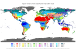
Arusha, Tanzania (Cwb) Atok, Philippines (Cwb) Cajamarca, Peru (Cwb) Cherrapunji, India (Cwb) Cusco, Peru (Cwb) Da Lat, Vietnam (Cwb) Dali City, China...
126 KB (11,274 words) - 20:49, 16 August 2024

while droughts are becoming more frequent in the tropics and subtropics. Cherrapunji, situated on the southern slopes of the Eastern Himalaya in Shillong...
117 KB (11,783 words) - 05:05, 12 August 2024

The Kynrem Falls is located 12 kilometres (7.5 mi) from Cherrapunji in East Khasi Hills district in the Indian state of Meghalaya. It is situated inside...
2 KB (137 words) - 20:15, 28 June 2022

Tropical Cyclone Denise. Most in 48 hours (2 days): 2,493 mm (98.1 in); Cherrapunji, Meghalaya, India, 15–16 June 1995. Most in 72 hours (3 days): 3,929 mm...
190 KB (10,614 words) - 04:34, 16 August 2024

hills. The Garo–Khasi range lies in Meghalaya. Mawsynram, a village near Cherrapunji lying on the windward side of these hills, has the distinction of being...
84 KB (9,215 words) - 12:07, 5 August 2024

years the Cherrapunji-Mawsynram region has averaged between 9,296 and 10,820 millimetres (366 and 426 in) of rain annually, though Cherrapunji has had at...
103 KB (10,607 words) - 12:53, 16 August 2024