
Deep-ocean Assessment and Reporting of Tsunamis (DART) is a component of an enhanced tsunami warning system. By logging changes in seafloor temperature...
14 KB (1,823 words) - 14:45, 25 July 2024

Teletsunami (redirect from Ocean-wide tsunami)
India, and Somalia. It was the first teletsunami to have extensive video evidence. Cumbre Vieja tsunami hazard Deep-ocean Assessment and Reporting of Tsunamis...
15 KB (1,761 words) - 12:10, 15 August 2024

a tsunami is in deep water, it has little height and a network of sensors is needed to detect it. Tsunamis are more frequent in the Pacific Ocean than...
177 KB (18,869 words) - 17:32, 29 August 2024
Ocean Tsunami Warning System was set up to provide warning to inhabitants of nations bordering the Indian Ocean of approaching tsunamis. The tsunami warning...
5 KB (683 words) - 12:06, 8 July 2024

tsunami arrived, giving them some time to evacuate areas likely to be affected. Oceans portal Tsunamis portal Deep-ocean Assessment and Reporting of Tsunamis...
24 KB (2,545 words) - 04:28, 26 May 2024
Meteotsunami (redirect from Meteorological tsunami)
and three people were swept off a jetty, two seriously injured, when a six-foot wave struck the Barnegat Inlet. Deep-ocean Assessment and Reporting of...
13 KB (1,069 words) - 21:13, 14 August 2024
Global Sea Level Observing System (category Meteorological data and networks)
Global Sea Level Observing System does not compete with Deep-ocean Assessment and Reporting of Tsunamis as most GLOSS transducers are located close to land...
3 KB (392 words) - 00:25, 18 January 2024

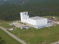
developing the Deep-ocean Assessment and Reporting of Tsunamis (DART) system. By 2001, an array of six stations had been deployed in the Pacific Ocean. Beginning...
17 KB (1,508 words) - 11:44, 29 March 2024

ACARS (redirect from Aircraft Communication Addressing and Reporting System)
Communications Addressing and Reporting System) is a digital datalink system for transmission of short messages between aircraft and ground stations via airband...
16 KB (1,843 words) - 14:46, 22 July 2024

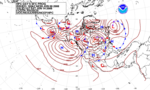
gauges, eight Deep-ocean Assessment and Reporting of Tsunamis (DART) stations, eight atmospheric pressure time series, spectral analysis and computer simulation...
204 KB (18,391 words) - 03:37, 19 August 2024
Dart (section Arts, entertainment and media)
transfer model used in remote sensing Deep-ocean Assessment and Reporting of Tsunamis, a component of an enhanced tsunami warning system Direct analysis in...
5 KB (683 words) - 17:18, 16 June 2024

Weather ship (redirect from Ocean Weather Station)
primarily located in the north Atlantic and north Pacific oceans, reporting via radio. The vessels aided in search and rescue operations, supported transatlantic...
31 KB (3,627 words) - 22:37, 19 August 2024
National Data Buoy Center (category National Environmental Satellite, Data, and Information Service)
Conductivity and water current are measured at selected stations. A new task is the operation of the DART (Deep-ocean Assessment and Reporting of Tsunamis) buoys...
5 KB (617 words) - 04:02, 6 January 2024

METAR (redirect from Aviation routine weather report METAR)
METAR is a format for reporting weather information. A METAR weather report is predominantly used by aircraft pilots, and by meteorologists, who use aggregated...
34 KB (2,503 words) - 17:21, 1 July 2024

patent on the Deep-ocean Assessment and Reporting of Tsunamis DART® tsunami detection buoy that forms the backbone of the global tsunami detection network...
4 KB (405 words) - 06:04, 17 March 2022
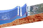
Ring of Fire, tsunamis occur most frequently in the Pacific Ocean, but are a worldwide natural phenomenon. They are possible wherever large bodies of water...
148 KB (5,835 words) - 03:28, 26 August 2024

and the National Oceanic and Atmospheric Administration's Hurricane Hunters. Such missions have also been flown by Navy units and other Air Force and...
23 KB (2,408 words) - 01:40, 28 August 2024
Weather forecasting (redirect from Weather forecasting and prediction)
atmosphere, the land, and the ocean, the error involved in measuring the initial conditions, and an incomplete understanding of atmospheric and related processes...
80 KB (7,972 words) - 21:25, 3 August 2024
This is a list of devices used for recording and give output readings of various aspects of the weather. Weather stations typically have these following...
4 KB (260 words) - 21:25, 1 July 2024

"Life of a Tsunami". Tsunamis & Earthquakes. US Geological Survey. Retrieved July 14, 2021. "Physics of Tsunamis". National Tsunami Warning Center of the...
127 KB (16,965 words) - 18:02, 20 August 2024

Panel on Ocean Atmosphere Interaction (1974). The role of the ocean in predicting climate: a report of workshops conducted by Study Panel on Ocean Atmosphere...
8 KB (940 words) - 08:20, 4 July 2024
Laboratory (PMEL) in Seattle, Washington, designed Deep-ocean Assessment and Reporting of Tsunamis (DART-II) technology, which provides two-way communication...
14 KB (1,474 words) - 13:06, 3 March 2024

Weather buoy (category Meteorological data and networks)
coloured yellow, and display a yellow flashing light at night. Discus buoys are round and moored in deep ocean locations, with a diameter of 10–12 metres...
19 KB (2,129 words) - 03:14, 24 August 2024

Physical oceanography (redirect from Ocean physics)
oceanography is the study of physical conditions and physical processes within the ocean, especially the motions and physical properties of ocean waters. Physical...
31 KB (3,737 words) - 19:27, 12 August 2024

the quality and volume of ocean data since the IPCC Fourth Assessment Report and the resulting improvement in confidence in the description of surface salinity...
24 KB (2,843 words) - 23:40, 10 July 2024

the world. Deep ocean tsunami sensor detection of an event. In 1995, NOAA began developing the Deep-ocean Assessment and Reporting of Tsunamis (DART) system...
12 KB (1,198 words) - 23:53, 24 November 2023
ability to provide a fast and accurate assessment of the data quality. Ocean Networks Canada is in the process of implementing real-time quality control...
16 KB (1,406 words) - 14:59, 22 December 2023

Weather balloon (category Meteorological instrumentation and equipment)
type of high-altitude balloon) that carries instruments to the stratosphere to send back information on atmospheric pressure, temperature, humidity and wind...
11 KB (1,040 words) - 01:51, 22 August 2024

Automated airport weather station (category Meteorological data and networks)
The message is updated at least once per minute, and this is the only mandatory form of weather reporting for an AWOS. Optionally, a computer-generated voice...
30 KB (3,562 words) - 09:38, 16 February 2024

Meteorology (redirect from Slight Risk Of Severe Thunderstorms)
hydrometeorology. The interactions between Earth's atmosphere and its oceans are part of a coupled ocean-atmosphere system. Meteorology has application in many...
93 KB (9,893 words) - 12:40, 29 August 2024