
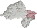
Khar Bajaur Tehsil (Pashto: خار باجوړ تحصیل), sometimes shortened to Khar Tehsil, is an administrative subdivision (tehsil) of Bajaur District in Khyber...
8 KB (608 words) - 05:24, 28 November 2024

in size, Bajaur occupies a small mountain basin and is into seven tehsil (subdistricts) with its district headquarters in the town of Khar, in the district's...
48 KB (4,109 words) - 15:00, 16 December 2024

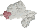
northernmost region of Bajaur District, Salarzai shares a 22.35 km border with Khar Bajaur Tehsil to the south, a 17.05 km border with Mamund Tehsil to the west...
6 KB (408 words) - 04:19, 10 November 2024
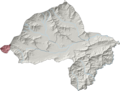
Bajaur District's central-eastern shoulder, Utman Khel shares a 19.95 km border with Barang Tehsil to the south, a 13.30 km border with Khar Bajaur Tehsil...
6 KB (424 words) - 22:42, 22 October 2024
disenfranchised by Islamabad. Mamund Tehsil Khar Bajaur Tehsil Salarzai Tehsil Nawagai Tehsil Utman Khel Tehsil Barang Tehsil Bajaur District Khyber Pakhtunkhwa...
8 KB (605 words) - 00:19, 9 November 2024

Bajaur District's north-central region, Mamund shares a 16.55 km border with Salarzai Tehsil to the east, a 23.27 km border with Khar Bajaur Tehsil to...
8 KB (622 words) - 06:19, 20 December 2024

Orakzai Tehsil Upper Orakzai Tehsil Bar Chamarkand Tehsil Barang Tehsil Khar Bajaur Tehsil Mamund Tehsil Nawagai Tehsil Salarzai Tehsil Utman Khel Tehsil Chagharzai...
18 KB (505 words) - 16:16, 19 November 2024

Malakand Division (section List of the Tehsils)
Shangla, Buner, Malakand, Dir Upper & Lower, Chitral Upper & Lower and Bajaur Tribal District with a total area of 32007Kms having population of 8.7 million...
12 KB (559 words) - 03:45, 30 December 2024
disenfranchised by Islamabad. Mamund Tehsil Khar Bajaur Tehsil Salarzai Tehsil Utman Khel Tehsil Barang Tehsil Bar Charmer Kand Tehsil 34°40′02″N 71°17′37″E / 34...
6 KB (423 words) - 23:19, 10 November 2024

Ambar Utmankhel Tehsil to the west, an 11.01 km border with Khar Bajaur Tehsil to the northwest, a 19.95 km border with Utman Khel Tehsil to the northeast...
8 KB (603 words) - 05:24, 28 November 2024
Inayat Killi (category Populated places in Bajaur District)
Inayat Killi (or Inayat Qilla) is a town in Khar Bajaur Tehsil, Bajaur Agency, Federally Administered Tribal Areas, Pakistan. The population is 10,717...
3 KB (80 words) - 16:31, 10 November 2023

Khel Tehsil, Barang Tehsil, Khar Bajaur Tehsil, Bar Chamarkand Tehsil, Nawagai Tehsil, and Mandal and Shamozai sections of Salarzai Tehsil in Bajaur District...
7 KB (242 words) - 17:53, 20 October 2024
Sadiq Abad, Khyber Pakhtunkhwa (category Populated places in Bajaur District)
Sadiq Abad is a town in Khar Bajaur Tehsil, Bajur, Khyber Pakhtunkhwa, Pakistan. The population is 10,060 according to the 2017 census. "POPULATION AND...
2 KB (65 words) - 00:06, 11 November 2023
Prang Ghar (redirect from Pringhar Tehsil)
Prang Ghar is a tehsil located in Mohmand District, Khyber Pakhtunkhwa, Pakistan. It's about 70km from Peshawar. The population is 35,290 according to...
5 KB (318 words) - 09:30, 4 November 2024

PK-22 Bajaur-IV (پی کے-22 باجوڑ-4) is a constituency for the Khyber Pakhtunkhwa Assembly of the Khyber Pakhtunkhwa province of Pakistan.It was created...
5 KB (153 words) - 05:24, 28 November 2024
abandoned, and the army troops withdrew to Khar, the main town of Bajaur Agency. There were reports that the town of Khar was then besieged by tribal militants...
242 KB (20,895 words) - 01:47, 10 January 2025
Serwekai Tehsil is a subdivision located in South Waziristan district, Khyber Pakhtunkhwa, Pakistan. The population is 54,278 according to the 2017 census...
3 KB (56 words) - 18:37, 16 August 2024
Ismailzai Tehsil is a subdivision located in Orakzai District, Khyber Pakhtunkhwa, Pakistan. The population is 23,965 according to the 2017 census. List...
3 KB (61 words) - 10:16, 19 March 2024

Toi Khullah Tehsil is a subdivision located in Lower South Waziristan District District, Khyber Pakhtunkhwa, Pakistan. The population is 50,593 according...
3 KB (56 words) - 10:16, 19 March 2024

Upper Kurram Tehsil is a subdivision located in Kurram District, Khyber Pakhtunkhwa, Pakistan. The population is 253,478 according to the 2017 census....
5 KB (244 words) - 10:11, 19 March 2024
Ekka Ghund Tehsil is a subdivision located in Mohmand District, Khyber Pakhtunkhwa, Pakistan. The population is 52,291 according to the 2017 census. List...
3 KB (53 words) - 10:16, 19 March 2024

Tehsil, Orakzai Agency (south) Central Orakzai Tehsil, Orakzai Agency (south) Upper Orakzai Tehsil, Orakzai Agency (southwest) Central Kurram Tehsil,...
6 KB (311 words) - 12:57, 26 October 2024

Tiarza Tehsil is a subdivision located in South Waziristan District, Khyber Pakhtunkhwa, Pakistan. The population is 45,210 according to the 2017 census...
3 KB (56 words) - 13:54, 12 November 2024
Mir Ali Tehsil is a subdivision located in North Waziristan district, Khyber Pakhtunkhwa, Pakistan. The population is 185,525 according to the 2017 census...
3 KB (90 words) - 15:38, 23 December 2024
Central Kurram Tehsil is a subdivision located in Kurram District, Khyber Pakhtunkhwa, Pakistan. The population is 229,356 according to the 2017 census...
4 KB (132 words) - 08:43, 15 June 2024
Lower Kurram Tehsil is a subdivision located in Kurram District, Khyber Pakhtunkhwa, Pakistan. The population is 136,719 according to the 2017 census....
4 KB (162 words) - 10:16, 19 March 2024

Mullagori Tehsil is a subdivision located in Khyber District, Khyber Pakhtunkhwa, Pakistan. It is located among the Tahtara hills on its west side and...
11 KB (1,105 words) - 18:00, 16 November 2024
Datta Khel Tehsil is a subdivision located in North Waziristan district, Khyber Pakhtunkhwa, Pakistan. The population is 75,116 according to the 2017 census...
3 KB (63 words) - 10:07, 19 March 2024
arrangement of the seven Tribal Areas in order from north to south was: Bajaur, Mohmand, Khyber, Orakzai, Kurram, North Waziristan, South Waziristan. The...
44 KB (3,954 words) - 09:00, 11 January 2025
Gharyum Tehsil is a subdivision located in North Waziristan district, Khyber Pakhtunkhwa, Pakistan. The population is 11,780 according to the 2017 census...
3 KB (62 words) - 10:16, 19 March 2024