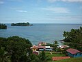
Kusapín (Saborikäte ) is a district of the county Panamanian indigenous Ngabe Bugle. Its capital is the town of Kusapín. It has an area of 1,693.2 km2...
3 KB (207 words) - 15:04, 7 October 2022
Kusapín District is a district (distrito) of Ngäbe-Buglé Comarca in Panama. Kusapín District is divided administratively into the following corregimientos:...
4 KB (60 words) - 07:21, 29 November 2023

Tolote [citation needed] Bisira Kusapín District Kusapín, Bahía Azul, Cañaveral [citation needed], Río Chiriquí, Tobobé Kusapín Jirondai District Samboa, Büri...
20 KB (1,938 words) - 16:23, 2 October 2024

Guararé Guarumal Guarumal Horconcitos Icantí Ipetí Jaqué Kanir-Dup Kankintú Kusapin La Cabima La Chorrera La Concepcion La Espigadilla La Loma La Mata La Mitra...
8 KB (414 words) - 05:11, 8 October 2023
Bahía Azul Corregimiento Country Panama Comarca Indígena Ngäbe-Buglé Comarca District Kusapín Time zone UTC−5 (EST)...
2 KB (68 words) - 16:27, 8 November 2020
Calovébora o Santa Catalina Corregimiento Country Panama Comarca Indígena Ngäbe-Buglé Comarca District Kusapín Time zone UTC−5 (EST)...
2 KB (54 words) - 16:27, 8 November 2020

Rodelick Richards (PP) 24.86% 12–1 Ngäbe-Buglé Comarca Kankintú District Kusapín District Jirondai District Santa Catalina o Calovébora District Leopoldo...
161 KB (9,572 words) - 11:29, 24 July 2024

Yes Ngäbe-Buglé Comarca Leopoldo Archibold CD 12-1 Jirondai, Kankintú, Kusapín, Santa Catalina o Calovébora — — Adán Bejerano Unaffiliated 12-2 Besikó...
67 KB (4,189 words) - 03:15, 15 October 2024
Loma Yuca Corregimiento Country Panama Comarca Indígena Ngäbe-Buglé Comarca District Kusapín Time zone UTC−5 (EST)...
2 KB (68 words) - 16:28, 8 November 2020
81°49′59.9″W / 9.116694°N 81.833306°W / 9.116694; -81.833306 Country Panama Comarca Indígena Ngäbe-Buglé Comarca District Kusapín Time zone UTC−5 (EST)...
2 KB (51 words) - 18:52, 27 February 2023
-81.77917 Country Panama Comarca Indígena Ngäbe-Buglé Comarca District Kusapín Area • Land 257.1 km2 (99.3 sq mi) Population • Total 2,898 Time zone...
2 KB (57 words) - 18:46, 27 February 2023
Ngäbe-Buglé Comarca Jirondai Samboa 24,150 Kankintú Bisira 2,422.1 33,121 Kusapín Kusapín 1,693.2 20,909 Mironó Hato Pilón 343.1 15,010 Müna Chichica 796.4 36...
8 KB (26 words) - 01:42, 24 May 2024

Kankintú District is a district (distrito) of Ngäbe-Buglé Comarca in Panama. Kusapín District is divided administratively into the following corregimientos:...
4 KB (61 words) - 07:37, 29 November 2023
Río Chiriquí Corregimiento Country Panama Comarca Indígena Ngäbe-Buglé Comarca District Kusapín Time zone UTC−5 (EST)...
2 KB (68 words) - 20:20, 8 February 2021
Kribo, Kädriri, Nedrini The Seven Districts: Besiko, Jirondai, Kankintu, Kusapín, Mirono, Münä, Nole Duima, Ñürüm, Santa Catalina o Calovébora (Bledeshia)...
25 KB (3,383 words) - 04:09, 11 October 2024
Tuwai Man Creek Bisira Kusapín Bahía Azul Calovébora o Santa Catalina Kusapín Río Chiriquí Tobobé Loma Yuca Valle Bonito Kusapín Mironó Cascabel Hato Corotú...
31 KB (135 words) - 12:20, 30 April 2024
62 metres (203 ft) 0022 G3269 14 Isla Escudo de Vargas Lighthouse n/a Kusapin 9°05′24.0″N 81°32′42.0″W / 9.090000°N 81.545000°W / 9.090000; -81.545000...
7 KB (173 words) - 20:53, 13 August 2023