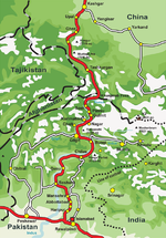
The Leh–Manali Highway is a 428 km (266 mi) long highway in northernmost India connecting Leh, the capital of the Union Territory of Ladakh, to Manali in...
19 KB (1,631 words) - 21:34, 17 October 2024
to Srinagar in the southwest and to Manali in the south via the Leh-Manali Highway (part of National Highway 3). Leh was for centuries an important stopover...
40 KB (4,238 words) - 10:25, 7 November 2024
Rohtang Pass (category Transport in Manali, Himachal Pradesh)
Lahaul and Spiti district and on to Leh in Ladakh is not a national highway. Nonetheless, the Leh-Manali Highway has become very busy during the summer...
9 KB (951 words) - 18:01, 29 August 2024
and Leh on this route with an overnight halt at Kargil. Taxis (cars and jeeps) are also available at Srinagar for the journey. Leh-Manali Highway List...
7 KB (518 words) - 21:34, 17 October 2024
Srinagar for the journey. National Highway 3 or Leh-Manali Highway Since 1989, the 473-km Leh-Manali Highway has been serving as the second land approach to...
31 KB (2,288 words) - 21:13, 14 November 2024
Atal Tunnel (category Transport in Manali, Himachal Pradesh)
Shinku La Tunnel, which is targeted to be completed by 2025, the new Leh-Manali Highway via Nimmu–Padum–Darcha road will become all-weather road. It is named...
29 KB (3,066 words) - 09:47, 18 November 2024
la) to cater to the traffic on the existing NH3 Leh–Manali Highway and the under-construction Bhanupli–Leh line.[citation needed] The two headwaters of the...
8 KB (860 words) - 09:21, 12 March 2024
Leh Leh-Manali Highway List of National Highways in India by highway number National Highways Development Project "New Numbering of National Highways...
10 KB (531 words) - 21:43, 17 October 2024
China. Manali is a popular tourist destination in India and serves as the gateway to the Lahaul and Spiti district as well as the city of Leh in Ladakh...
15 KB (1,089 words) - 12:08, 14 November 2024
(44 mi) north of Manali via Atal Tunnel and 120 km (75 mi) from the Indo-Tibetan border. It is located along the Manali-Leh Highway, about 7 km (4+1⁄2 mi)...
10 KB (737 words) - 09:09, 21 October 2024
Gya, Ladakh (redirect from Gya, Leh)
or Gia is a village in the Leh district of Ladakh in India. It is located in the Kharu tehsil, off the Leh–Manali Highway, close to Tso Kar. The village...
5 KB (217 words) - 03:00, 31 January 2023
Nimmu–Padum–Darcha road (redirect from Zanskar Highway)
Darcha village in Lahul and Spiti. It provides an alternative to the Leh–Manali Highway in linking Ladakh with the rest of India. It was built by the Border...
19 KB (1,881 words) - 11:04, 3 October 2024
in the Indian union territory of Ladakh. It is located on the NH3 Leh–Manali Highway. Rail-cum-road tunnels are being constructed under the Taglang La...
2 KB (167 words) - 18:00, 6 April 2024
major halt point with tented accommodation in the Himalayas on the Leh-Manali Highway, on the boundary between Himachal Pradesh and Ladakh in India. It...
6 KB (542 words) - 09:20, 16 April 2022
Ladakh Leh–Manali Highway Araniko Highway National Highway 5 (India) – An alternate route for access to the Arabian Sea from China National Highways of Pakistan...
33 KB (3,202 words) - 09:25, 1 November 2024
reduce the Manali to Kargil distance by 522 km. This will provide an all-weather route to Ladakh, as an alternative to the Leh–Manali Highway. There is...
11 KB (1,097 words) - 12:19, 22 November 2024
the Manali-Leh Highway. With the opening of the Atal Tunnel, Darcha is likely to see a large influx of tourists as it is now connected to Manali throughout...
7 KB (408 words) - 14:17, 27 July 2024
pilgrims at Sissu. August, 2010 Sissu waterfall Leh–Manali Highway Satellite map of Sissu Ladakh, Kashmir, Manali: Sissu is going to be a hot destination now...
5 KB (486 words) - 17:04, 19 October 2024
national highway is NH766EE, which spans 4.27 km (2.65 mi), from Hettikeri to Belekeri port in Karnataka. The Leh–Manali Highway connecting Leh in Ladakh...
27 KB (1,730 words) - 14:45, 4 November 2024
Kaza, Himachal Pradesh (section Highways)
central location and connections to the rest of the valley (Connects to Leh-Manali Highway via Kunzum Pass). This central location also makes Kaza an ideal base...
14 KB (1,329 words) - 04:14, 28 October 2024
village in the Leh district of Ladakh, India. It is located in the Kharu tehsil, 40 km southeast of Leh town on the Leh-Manali Highway and under-construction...
7 KB (423 words) - 19:07, 8 July 2024
Hemis village is located 40 km southeast of Leh on Leh-Manali Highway and under-construction Bhanupli–Leh line. Hemis Monastery existed before the 11th...
9 KB (1,074 words) - 16:40, 8 August 2024
on the Leh–Manali Highway. Kiang Chu Thang means a plain where the kiang (Tibetan wild ass) does not find water. It occupies 40 km of the highway between...
2 KB (217 words) - 05:52, 22 September 2024
just north of border with Himachal Pradesh. It is located on the NH3 Leh–Manali Highway, 54 km (34 mi) north of Sarchu and 24 km (15 mi) west of Pang. Rail-cum-road...
2 KB (179 words) - 14:07, 17 August 2023
road junction on the Leh-Manali Highway in the union territory of Ladakh in India. It is located 47 km (29 mi) to the southeast of Leh along the Indus river...
5 KB (204 words) - 12:48, 8 July 2024
Lahaul Spiti district. It is accessible by National Highway NH 21, also known as the Leh-Manali Highway. The road skirts Suraj Tal, which is just 3 km (1...
9 KB (910 words) - 00:28, 6 December 2023
Spiti over the 1950s-60s. By the 1970s, Spiti had road connectivity to Manali and Shimla. The Spiti valley is located between the Kunzum range in the...
58 KB (6,128 words) - 10:44, 20 November 2024
territory of Ladakh that separates the Zanskar valley from Indus valley at Leh. The range lies between and runs parallel to the Great Himalayas to the southwest...
3 KB (245 words) - 12:38, 29 October 2024
Karu, Ladakh (category Cities and towns in Leh district)
the Leh district of Union territory of Ladakh in India. It is located 34 km southeast of Leh on Leh-Manali Highway and under-construction Bhanupli–Leh line...
7 KB (437 words) - 08:32, 2 September 2024
off, though an alternative (and longer) road to Leh existed via Himachal Pradesh, the Leh–Manali Highway. The infiltrators, apart from being equipped with...
152 KB (13,503 words) - 07:09, 17 November 2024


