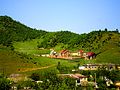
Madzhalis (Russian: Маджалис; Dargwa: Мажалис) is a rural locality (a selo) and the administrative center of Kaytagsky District of the Republic of Dagestan...
8 KB (1,385 words) - 03:18, 27 August 2024
part of the village of Madzhalis. Before the Russian Revolution of 1917, a large community of Mountain Jews lived in Madzhalis, making up the Tuben-Aul...
5 KB (434 words) - 21:53, 25 May 2024
selo of Novokayakent 54089 Kaytagsky District Кайтагский район selo of Madzhalis 31368 Kazbekovsky District Казбековский район selo of Dylym 42752 Khasavyurtovsky...
276 KB (538 words) - 12:12, 5 October 2024

Dagestan of the Russian Federation. The district's administrative centre was Madzhalis. The prefectures (участки, uchastki) of the Kaytago-Tabasaranskiy okrug...
7 KB (427 words) - 21:44, 12 August 2024
locality (a selo) of Madzhalis. As of the 2010 Census, the total population of the district was 31,368, with the population of Madzhalis accounting for 21...
5 KB (888 words) - 22:44, 27 September 2022
reported that he was the son of a kulak. In the spring of 1927 he moved to Madzhalis, Kaytagsky District, where he created a school for the Mountain Jews....
6 KB (632 words) - 21:15, 2 May 2024
streets. Akhmedkent is located 2 km west of Madzhalis (the district's administrative centre) by road. Madzhalis and Sanchi are the nearest rural localities...
4 KB (165 words) - 05:18, 29 November 2023

Caucasian militia units. In 1831, during the occupation of the village of Madzhalis in Dagestan, he was wounded by a rifle bullet in his left hand with damage...
6 KB (697 words) - 06:50, 25 March 2024
Rodnikovy is located 11 km northeast of Madzhalis (the district's administrative centre) by road. Madzhalis and Sanchi are the nearest rural localities...
3 KB (96 words) - 04:58, 19 October 2021
Ulluchay River. It is located 2 km northwest of Madzhalis (the district's administrative centre) by road. Madzhalis and Akhmedkent are the nearest rural localities...
3 KB (107 words) - 23:15, 27 September 2022
Barshamay is located 6 km southeast of Madzhalis (the district's administrative centre) by road. Madzhalis and Kartalay are the nearest rural localities...
3 KB (120 words) - 22:03, 3 January 2024

(literally, “Jewish fortress”, “fortress of the Jews”); the gorge near Madzhalis is Dzhut-Gatta, and the mountain in this area is Dzhufudag, which is,...
8 KB (901 words) - 04:35, 9 October 2024
158 km north of Kurakh (the district's administrative centre) by road. Madzhalis and Urkarakh are the nearest rural localities. Lezgins live there. Село...
3 KB (102 words) - 17:58, 29 September 2022

558.40 sq mi) Kaytago-Tabasaranskiy okrug (Кайтаго-Табасаранский округ) Madzhalis 1,327 --- 91,021 82,154 2,896.54 square versts (3,296.44 km2; 1,272.76 sq mi)...
15 KB (499 words) - 16:03, 6 October 2024
Dagestan, Russia. There are 23 streets. Yangikent is located 12 km north of Madzhalis (the district's administrative centre) by road, on the Yangichay River...
5 KB (417 words) - 19:53, 25 April 2024
Boinak (seat of Vice-Shamkhals), Bashly, Erpeli, Karabudaghkent, and Madzhalis. Other important towns and settlements include Heli, Paraul, Zhengutay...
28 KB (3,049 words) - 06:54, 18 May 2024

Karatsan Kartalay Khadagi Khungiya Kirki Kirtsik Kulegu Kulidzha Lishcha Madzhalis Mallakent Mizhigli Novaya Barsha Pilyaki Rodnikovy Ruka Sanchi Shilansha...
30 KB (1,518 words) - 21:48, 4 August 2024
of 2010. There are 21 streets. Mizhigli is located 7 km southwest of Madzhalis (the district's administrative centre) by road. Dzhigiya, Shilyagi and...
3 KB (101 words) - 23:11, 27 September 2022
as of 2010. There are 4 streets. Khungiya is located 4 km southwest of Madzhalis (the district's administrative centre) by road. Gaziya and Mizhigli are...
3 KB (110 words) - 19:07, 8 May 2023
of 2010. There are 7 streets. Dzhavgat is located 23 km southeast of Madzhalis (the district's administrative centre) by road. Ruka and Dzhibakhni are...
3 KB (116 words) - 22:59, 27 September 2022
The population was 145 as of 2010. Guldy is located 23 km southwest of Madzhalis (the district's administrative centre) by road. Surgiya and Dzurmachi...
3 KB (104 words) - 16:29, 21 December 2022
population was 82 as of 2010. Shilansha is located 33 km southwest of Madzhalis (the district's administrative centre) by road. Kirki and Turaga are the...
3 KB (90 words) - 23:21, 27 September 2022
The population was 40 as of 2010. Surkhavkent is located 25 km south of Madzhalis (the district's administrative centre) by road. Varsit and Shuragat are...
3 KB (92 words) - 23:16, 27 September 2022
The population was 174 as of 2010. Kirki is located 29 km southwest of Madzhalis (the district's administrative centre) by road. Turaga and Kuzhnik are...
3 KB (108 words) - 18:48, 13 May 2023
as of 2010. There are 6 streets. Kartalay is located 9 km southeast of Madzhalis (the district's administrative centre) by road. Karatsan and Dzhinabi...
3 KB (100 words) - 23:06, 27 September 2022
population was 163. There are 6 streets. Adaga is located 20 km southwest of Madzhalis (the district's administrative centre) by road. Kulidzha and Shilyagi...
3 KB (115 words) - 22:42, 27 September 2022
The population was 96 as of 2010. Kirtsik is located 26 km south of Madzhalis (the district's administrative centre) by road. Varsit and Shuragat are...
3 KB (106 words) - 01:51, 14 May 2023
of 2010. There are 2 streets. Novaya Barsha is located 9 km north of Madzhalis (the district's administrative centre) by road. Yangikent and Chumli are...
3 KB (120 words) - 23:12, 27 September 2022
of 2010. There are 2 streets. Karatsan is located 17 km southwest of Madzhalis (the district's administrative centre) by road. Dzhirabachi and Daknisa...
3 KB (98 words) - 23:15, 27 September 2022
as of 2010. There are 2 streets. Lishcha is located 17 km southwest of Madzhalis (the district's administrative centre) by road. Surgiya and Daknisa are...
3 KB (98 words) - 23:10, 27 September 2022