
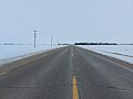
Provincial Road 280 (PR 280) is a road in the Canadian province of Manitoba. It runs from PR 391 northwest of Thompson to local streets in Gillam. The...
10 KB (939 words) - 23:45, 26 May 2024

province of Manitoba. PR 290 begins at an intersection with Manitoba Provincial Road 280 in Jacam and heads to the northeast towards the abandoned town...
3 KB (300 words) - 01:17, 27 May 2024

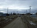
service did not resume until December 2018. Manitoba Provincial Road 280 links Gillam to the rest of Manitoba, making it one of the northernmost communities...
16 KB (1,303 words) - 01:12, 4 June 2024
a list of Manitoba provincial trunk highways and provincial roads. Provincial Trunk Highways are the primary highways, and Provincial Roads are the secondary...
106 KB (1,972 words) - 22:59, 21 August 2024
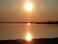
The lake and the town of Gillam are accessed by Manitoba Provincial Road 280. List of lakes of Manitoba "Google Maps Distance Calculator". Retrieved 7...
3 KB (163 words) - 23:30, 24 April 2024
via Plovdiv A1 road (Canada) may refer to a class of provincial roads in Manitoba, Canada: see for instance Manitoba Provincial Road 280 A1 motorway (Croatia)...
5 KB (736 words) - 17:03, 13 August 2024

Northern Manitoba. The city is served by road via an all-weather road, Manitoba Provincial Road 280, Manitoba Provincial Road 391, and Manitoba Highway...
54 KB (4,530 words) - 18:15, 21 July 2024

Provincial Road 542 (PR 542) is a road in southwestern Manitoba, Canada. At its southern end, it intersects with Manitoba Provincial Road 257 at Kola...
2 KB (62 words) - 21:01, 1 June 2024
Wapusk Trail (category Roads in Manitoba)
Trail is a winter road that starts in Gillam, Manitoba, where Manitoba Provincial Road 280, between Thompson, Manitoba and Gillam, Manitoba, ends. At 752...
1 KB (166 words) - 07:13, 30 May 2023

Provincial Road 391 (PR 391) is an all-weather gravel road connecting Thompson and Lynn Lake, in the Canadian province of Manitoba. PR 391 is located in...
13 KB (1,176 words) - 22:23, 31 May 2024

passes twice under Manitoba Provincial Road 280: once near its source, and once just before its mouth. List of rivers of Manitoba "Sky Pilot Creek". Geographical...
2 KB (83 words) - 01:03, 4 August 2021
Route 280, or Highway 280, may refer to: McIvor Highway Manitoba Provincial Road 280 New Brunswick Route 280 Japan National Route 280 Interstate 280 (multiple...
2 KB (148 words) - 22:59, 4 April 2024
Provincial Trunk Highway 1 (PTH 1) is Manitoba's section of the Trans-Canada Highway. It is a heavily used, 4-lane divided highway, with the exception...
30 KB (1,552 words) - 19:06, 19 August 2024
McNally (1940). Road map of Western and Central Canada (Map). Rand McNally and Company. The H.M. Gousha Company (1956). "Saskatchewan & Manitoba" (Map). Shell...
112 KB (560 words) - 20:34, 6 February 2024
(89 mi) northeast of Thompson, roughly the halfway point of PR 280 in Northern Manitoba, and 169 km (105 mi) west of Gillam. In 1908, Tataskweyak Cree...
11 KB (730 words) - 03:47, 14 September 2023
List of highways numbered 1 (redirect from Provincial Highway No. 1)
For roads numbered A1, see list of A1 roads. For roads numbered B1, see list of B1 roads. For roads numbered M1, see List of M1 roads. For roads numbered...
20 KB (1,281 words) - 22:26, 13 August 2024

and Duck Mountain Provincial Park and Forest, the vast majority of unincorporated areas in the province are within Northern Manitoba. Statistics Canada...
123 KB (1,752 words) - 15:52, 20 August 2024
Highway 9 near Hinchcliffe east to the Manitoba border where it continues as Provincial Road 275 near Crestview, Manitoba. The highway passes through the communities...
74 KB (6,027 words) - 15:32, 15 August 2024
List of highways numbered 427 (redirect from State Road 427)
are numbered 427: Manitoba Provincial Road 427 Ontario Highway 427 National Highway 427 (India) Japan National Route 427 County Road 427 (Seminole County...
1 KB (105 words) - 23:15, 4 April 2024

called Pointe-Coupée, is a community in the Rural Municipality of Ritchot, Manitoba, Canada. It is located along the east bank of the Red River, approximately...
19 KB (1,586 words) - 14:27, 16 April 2024
List of highways numbered 401 (redirect from Federal Road 401)
(former) Manitoba Provincial Road 401 Ontario Highway 401 National Route 401 Road to El Fe (4–401) Japan National Route 401 Norwegian County Road 401 Thailand...
2 KB (153 words) - 20:08, 4 August 2024
List of highways numbered 405 (redirect from State Road 405)
refer to: Manitoba Provincial Road 405 Newfoundland and Labrador Route 405 Ontario Highway 405 National Route 405 Japan National Route 405 A405 road Interstate 405...
2 KB (152 words) - 22:25, 4 April 2024
List of highways numbered 416 (redirect from State Road 416)
The following highways are numbered 416: Manitoba Provincial Road 416 Newfoundland and Labrador Route 416 Highway 416 (Ontario) National Route 416 Japan...
1 KB (109 words) - 23:16, 4 April 2024
List of highways numbered 417 (redirect from State Road 417)
The following highways are numbered 417: Manitoba Provincial Road 417 Newfoundland and Labrador Route 417 Ontario Highway 417 National Route 417 Route...
1 KB (112 words) - 23:16, 4 April 2024
2019 Northern British Columbia murders (category 2019 in Manitoba)
surrounding area. A checkpoint was set up at the intersection of Provincial Roads 280 and 290, with heavily armed officers canvassing the area. The RCMP...
25 KB (2,448 words) - 23:36, 11 August 2024
Ebb and Flow First Nation (category First Nations governments in Manitoba)
180 km from Winnipeg, and lies on the west side of Lake Manitoba, on Manitoba Provincial Road 278. The reserve is known as Ebb and Flow 52, which is surrounded...
3 KB (164 words) - 14:30, 24 May 2024

Tataskweyak Cree Nation (category First Nations governments in Manitoba)
located at Split Lake, Manitoba, on the Nelson River system. Despite its remote location, it is serviced by Provincial Road 280, which connects the community...
4 KB (189 words) - 15:07, 8 July 2024
List of highways numbered 403 (redirect from State Road 403)
numbered 403: Manitoba Provincial Road 403 Newfoundland and Labrador Route 403 Highway 403 (Ontario) National Route 403 D403 road Main road 403 (Hungary)...
2 KB (136 words) - 22:25, 4 April 2024
the provincial boundary from the junction with PR 487 just north of Benito to the junction with PTH 57. PTH 83 first appeared on the 1953 Manitoba Highway...
12 KB (403 words) - 22:20, 15 June 2024
List of highways numbered 406 (redirect from State Road 406)
The following highways are numbered 406: Manitoba Provincial Road 406 Newfoundland and Labrador Route 406 Ontario Highway 406 National Route 406 Route...
2 KB (153 words) - 23:16, 4 April 2024