
Route 2A is a 98.5-mile-long (158.5 km) east–west state highway in Massachusetts. It exists in several sections, mainly as parts of former Route 2 that...
19 KB (902 words) - 01:07, 11 May 2024

Route 2 is a 142.29-mile-long (228.99 km) major east–west state highway in Massachusetts, United States. Along with Route 9 and U.S. Route 20 to the south...
34 KB (2,020 words) - 16:25, 24 August 2024
2A or II-A may refer to: Alberta Highway 2A Massachusetts Route 2A 2A self-cleaving peptides Alpha-2A adrenergic receptor IARC group 2A Keratin 2A Transcription...
796 bytes (130 words) - 21:48, 20 October 2023

Montville where it meets Route 2A at exit 9. Eastbound Route 2A provides access to the Mohegan Sun casino, while westbound Route 2A runs concurrently with...
21 KB (1,342 words) - 22:56, 13 October 2024
(former) Connecticut Route 2A Massachusetts Route 2A Nevada State Route 2A New York State Route 2A (mid-1920s–1927) New York State Route 2A (1930–1939) New...
927 bytes (105 words) - 15:54, 26 June 2024

Power Road. Massachusetts Route 2A and 110 (King Street) go to the west out of the community, leading 7 miles (11 km) to Ayer, and Routes 2A and 119 (Great...
8 KB (669 words) - 10:49, 16 April 2024

joins Route 2A (Massachusetts Avenue) westbound, crossing into Arlington. In the center of town, US 3 and Route 2A split from Massachusetts Avenue and overlap...
55 KB (3,182 words) - 17:14, 8 October 2024

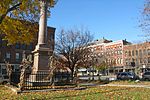
Paul Revere Capture Site (category 1775 in the Province of Massachusetts Bay)
shortly afterward. Monument detail, looking south toward Massachusetts Route 2A "Paul Revere Capture Site (U.S. National Park Service)". www.nps.gov. Retrieved...
3 KB (161 words) - 22:57, 19 April 2024

Route 3 is a state-numbered route in the U.S. state of Massachusetts, maintained by the Massachusetts Department of Transportation (MassDOT). Spanning...
19 KB (1,488 words) - 13:19, 5 June 2024

exist east of Harvard.) Route 111 begins in Concord at the rotary junction of Route 2, Route 2A and Route 119, next to Massachusetts Correctional Institution –...
7 KB (426 words) - 00:43, 11 May 2024

Route 128, known as the Yankee Division Highway, is an expressway in the U.S. state of Massachusetts maintained by the Highway Division of the Massachusetts...
59 KB (5,428 words) - 05:04, 14 October 2024
cities and towns. It largely parallels or joins Route 2 and Route 2A, all the way into central Massachusetts, with a few gaps at towns that have different...
13 KB (1,007 words) - 19:23, 1 August 2024
Trail follows Massachusetts Route 2A, which uses Route 2's former right of way through the center of Greenfield. At the town center, Route 2A meets the duplexed...
46 KB (4,634 words) - 22:10, 16 October 2024

city. Ashland, Massachusetts – Route 126 at Shaws Shopping Plaza Ayer, Massachusetts – Route 111 and Route 2A Cambridge, Massachusetts – Alewife Brook...
21 KB (2,566 words) - 12:10, 31 May 2024

Route 225 is a state highway in the U.S. state of Massachusetts. The highway runs 31.100 miles (50.051 km) from Route 2A in Lunenburg in northeastern Worcester...
9 KB (664 words) - 00:44, 21 September 2024

Route 119 is a 35.60-mile-long (57.29 km) northwest-southeast state highway in Massachusetts. Its western terminus is a continuation of New Hampshire Route...
6 KB (370 words) - 21:39, 18 October 2022

Retrieved December 24, 2019. MassDOT Planning Division. "Massachusetts Route Log Application". Massachusetts Department of Transportation. Archived from the original...
11 KB (864 words) - 01:05, 6 July 2024

Route 110 is a 69.24-mile-long (111.43 km) southwest–northeast state route in the U.S. state of Massachusetts. Route 110's western terminus is at a concurrency...
15 KB (845 words) - 22:40, 16 September 2024

as a six-lane highway, with the first northbound exits, 2A and 2B, providing access to Route 1A and nearby US 1 near the border. (There is an exit 1,...
39 KB (2,814 words) - 19:31, 25 August 2024

intersects with US Route 6 (US 6) in Johnston, Rhode Island, and US 44 in Smithfield, Rhode Island, before entering North Attleborough, Massachusetts, from Cumberland...
17 KB (1,186 words) - 20:20, 12 July 2024

Route 9 is a 135.310-mile-long (217.760 km) major east–west state highway in Massachusetts, United States. Along with U.S. Route 20 (US 20), Route 2, and...
24 KB (1,205 words) - 13:41, 23 September 2024

continuation of Rhode Island Route 126 by Woonsocket, Rhode Island and its northern terminus is at Route 2 and Route 2A in Concord. Along the way it intersects...
8 KB (410 words) - 00:55, 19 March 2023

Ayer and Littleton, Middlesex County, Massachusetts, United States. Massachusetts Route 2A and Massachusetts Route 110 pass through the community. It is...
4 KB (155 words) - 03:03, 17 May 2024

Arlington with Route 2 at that route's Exit 59 eastbound, continuing as Pleasant Street. From there, Route 60 joins U.S. Route 3 and Route 2A for a brief...
7 KB (455 words) - 01:00, 15 March 2023

Route 13 is a 14.14-mile-long (22.76 km) north–south state highway in the north-central region of the U.S. state of Massachusetts. Its southern terminus...
4 KB (245 words) - 02:12, 18 February 2024
terminus is at Route 119 in Ashburnham. Along the way it intersects several major highways including Route 2 and Route 2A in Templeton and Route 12 in Ashburnham...
6 KB (279 words) - 12:42, 31 August 2024

Route 31 is a 58.80-mile-long (94.63 km) north–south state highway in the U.S. state of Massachusetts. It runs from Dudley on the Connecticut border to...
10 KB (643 words) - 19:19, 12 April 2024

Route 1A is a north–south state highway in Massachusetts, United States. It is an alternate route to U.S. 1 with three signed sections and two unsigned...
17 KB (1,092 words) - 22:55, 30 September 2024

Route 78 is a state highway in the U.S. state of Massachusetts. The highway runs 9.73 miles (15.66 km) from Route 2A in Orange north to the New Hampshire...
3 KB (190 words) - 01:03, 15 March 2023

Related routes U.S. Route 50 Alternate State Route 2B, former spur of US 50 (as State Route 2A), no longer part of the state highway system State Route 2C...
59 KB (4,908 words) - 08:33, 18 August 2024