
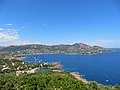
The Massif des Maures ([ma.sif de moʁ], "plateau of the Moors") is a small mountain range in southeastern France. It is located in the department of Var...
4 KB (559 words) - 19:43, 25 August 2024
fortified camps in the vicinity of Saint-Tropez in the middle of the Massif des Maures, with Fraxinetum as its chief town, which Arab written sources call...
12 KB (1,526 words) - 20:32, 20 February 2024

assisted by cave divers, searched the old Pic Martin lead mines in Cannet-des-Maures in Var. It was here that Jacques Massié and his family were found murdered...
64 KB (7,041 words) - 01:45, 23 July 2024

Saint Tropez, between the Mediterranean and the wooded hills of the Massif des Maures. This seaside and holiday destination of the commune of Roquebrune-sur-Argens...
3 KB (385 words) - 17:04, 25 August 2024

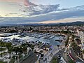
Saint-Tropez), stretching to Sainte-Maxime to the north under the Massif des Maures. Saint-Tropez was a military stronghold and fishing village until...
45 KB (4,089 words) - 09:58, 21 August 2024

(Maures in Old French), Arabs and Berbers from North Africa, who settled on the coast of Provence in the 9th and 10th centuries. The Massif des Maures...
105 KB (14,259 words) - 15:26, 14 August 2024

jumped into the Argens Valley between Le Luc and Le Muy, behind the Massif des Maures, a key piece of terrain which overlooked the Allied landing beaches...
24 KB (2,292 words) - 10:04, 18 July 2024

there, although the municipality is sheltered to the north by the Massif des Maures (the mistral coming from the west, and swaying to the east, south...
23 KB (2,414 words) - 23:47, 27 August 2024

modern-day Saint-Tropez, from which they controlled the mountains of the Massif des Maures and the coast between modern Fréjus and Hyères. Between 900 and 910...
75 KB (10,820 words) - 15:07, 21 May 2024

Alps and largely mountainous. Major mountains include: The Massif des Maures (771 m) and Massif de l'Esterel, along the coast, (618 m) are made of quartz...
24 KB (1,965 words) - 03:37, 19 August 2024
Mediterranean Sea of the Durance river. They appear to have lived in the Massif des Maures and the area that area stretching from Olbia (Hyères) to the Gulf...
2 KB (218 words) - 16:25, 16 May 2024
participate directly in the liberation of its sector, but joined the Massif des Maures and the coast in August 1944 to support the Provence landings. Le...
2 KB (179 words) - 21:09, 15 August 2024

Garde-Freinet is a medieval French mountain village, located in the Massif des Maures, 15 km northwest of Saint-Tropez. It is accessible via picturesque...
3 KB (248 words) - 12:18, 22 August 2024

the northern shore of the Gulf of Saint-Tropez. In the north the Massif des Maures mountain range protects it from the cold winds of the mistral. It...
12 KB (1,284 words) - 11:36, 22 August 2024
occurs, although sometimes the town is sheltered from this by the Massif des Maures and the Esterel. It is perhaps more exposed to the Levant (strong...
15 KB (1,398 words) - 07:32, 22 August 2024

Marazzi as basic shortcomings and inconsistencies: the inclusion of the Massif des Maures, which does not belong to the Alpine system either tectonically or...
17 KB (827 words) - 11:13, 28 May 2024

with the A570 spur to the town of Hyères. The motorway traverses the Massif des Maures and is mainly 2x2 lanes. The western terminus of the motorway links...
4 KB (405 words) - 03:45, 29 September 2023

region in southeastern France. La Croix-Valmer is at the foot of the Massif des Maures hills in the Bay of Cavalaire-sur-Mer, halfway between Le Lavandou...
3 KB (293 words) - 09:26, 25 August 2024

southeastern France. Specifically, it is restricted to the area of the Massif des Maures and the nearby Îles d'Hyères. Armadillidium quinquepustulatum prefers...
5 KB (543 words) - 20:46, 30 May 2024

basalts and microlitic-textured trachyandesites, characteristic of the Massif des Maures and the Toulon region and the later intrusion of Esterellite in the...
47 KB (4,684 words) - 04:52, 10 August 2024

than the crystalline rock of the old Precambrian massifs such as Estérel and Maures. "Carte écologique des Alpes au 1/100000: Feuille de Castellane" (PDF)...
5 KB (435 words) - 18:52, 2 August 2024

crosses the mountain ranges of Sainte-Baume and of Maures between Aix-en-Provence and Fréjus and the Massif de l'Esterel between Saint-Raphaël and Cannes....
8 KB (777 words) - 11:06, 15 April 2023

mountains of Sainte-Baume and Sainte-Victoire and, south-east the Massif des Maures (chain of mountains from the Alps to the Rhone). In 980, the family...
6 KB (800 words) - 13:25, 25 August 2024

D 98 (km 0) la Garde (km 2) la Crau (km 7) Hyères (km 13) la Londe-les-Maures (km 22) Bormes-les-Mimosas (km 31) la Môle (km 45) Cogolin (km 54) Port...
4 KB (555 words) - 01:53, 26 June 2024

area of the Alpes-Maritimes department, extending from the rock formation Massif de l'Esterel to Menton, at the France–Italy border, although some other...
52 KB (5,482 words) - 21:01, 11 August 2024
at 287 metres (942 ft) (Rastel d'Agay). The bay lies at the heart of the massif de l'Esterel, a volcanic mountain range of low altitude but steep slopes...
9 KB (1,086 words) - 14:39, 20 August 2024

"brutal beach", famous for windsurfing to the secret cove in the Sicié massif. The Île des Embiez is the site of an oceanographic research centre, and the smaller...
4 KB (296 words) - 11:14, 22 August 2024

mountaineering. From the Ciottulu a i Mori refuge, a path leads to the Col des Maures (Moorish Pass) and then up a very steep corridor on the western slope...
8 KB (636 words) - 22:35, 8 November 2023
result of their integration into other protected areas. RNF (2014). "Liste des réserves naturelles". Réserves Naturelles de France. Retrieved March 3, 2014...
42 KB (369 words) - 19:36, 5 July 2024

forming one urban agglomeration. The north of the commune forms part of the Massif de l'Esterel. On 2 December 1959, the Malpasset Dam, on the Reyran River...
24 KB (2,225 words) - 11:08, 21 August 2024