
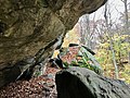
The Menunkatuck Trail is an 11.0-mile (17.7 km) Blue-Blazed hiking trail in Guilford, Connecticut and, currently, is almost entirely on protected land...
10 KB (975 words) - 19:30, 29 June 2024

a now (2013) complete connector trail (the Menunkatuck Trail) from the southernmost location of the Mattabesett Trail (in northern Guilford, Connecticut)...
10 KB (966 words) - 16:53, 5 September 2024

million restoration and includes a visitors' center and museum, hiking trails, and picnic area. William Gillette's "castle", called Seventh Sister and...
15 KB (1,305 words) - 00:41, 6 October 2024

Farmington Canal Heritage Trail, also known as the New Haven and Northampton Canal Greenway, is an 82-mile (132 km) multi-use rail trail located in Connecticut...
9 KB (990 words) - 21:16, 10 July 2024

European colonization, the area that became Guilford was the site of Menunkatuck, a Quinnipiac village. The Quinnipiac spoke Quiripi, one of the Eastern...
36 KB (2,800 words) - 20:02, 2 October 2024

Westwoods Trails is an extensive hiking trail system in Guilford, Connecticut. The trail system has approximately 39 miles (63 km) of trails with features...
5 KB (663 words) - 17:00, 28 April 2024

Sleeping Giant (Connecticut) (redirect from Sleeping Giant State Park Trails)
over 30 miles (48 km) of hiking trails traverse it including 5 miles (8 km) of the 23-mile (37 km) Quinnipiac Trail. Quinnipiac University is located...
21 KB (2,144 words) - 05:18, 2 September 2024

The Nayantaquit Trail is a 7-mile (11 km) Blue-Blazed hiking trail system in Lyme Connecticut and is entirely in the Nehantic State Forest western block...
6 KB (674 words) - 04:07, 25 July 2023

Chatfield Hollow State Park (category Hiking trails in Connecticut)
mountain biking trails in the state. Among them are the Lookout Trail and the Pond Trail, which is a side trail that loops off the Deep Woods Trail. Rock climbing...
9 KB (782 words) - 05:35, 6 August 2024
Regicides Trail is a Blue-Blazed hiking trail, about 7 miles (11 km) long, roughly following the edge of a diabase, or traprock, cliff northwest of New...
8 KB (1,016 words) - 11:20, 31 December 2023

The Ives Trail and Greenway is a 20-mile (32 km) hiking trail in the Housatonic Valley Region (also known as Greater Danbury). Its route connects Ridgefield...
4 KB (614 words) - 20:18, 20 May 2023
368 acre open space in Ridgefield, Connecticut. The space has many trails, trail heads and also one of Ridgefield's highest points, at 1,021 feet (311 m)...
3 KB (375 words) - 21:13, 18 June 2024

Cockaponset State Forest (redirect from Cockaponset Trail)
by hemlock. Hiking trails The Connecticut Department of Energy and Environmental Protection (CT DEEP) manages a 20-mile (32 km) trail system based around...
9 KB (779 words) - 07:36, 18 December 2023
Gay City State Park (redirect from Gay City Trails)
campground. The park's trail system, which is used for hiking and cycling, includes a five-mile trail that tours the entire park. Trails also connect Gay City...
8 KB (531 words) - 01:13, 8 October 2024

The Quinebaug Trail is a 8.1-mile (13.0 km) Connecticut hiking trail and is one of the Blue-Blazed hiking trails maintained by the Connecticut Forest and...
16 KB (2,011 words) - 02:54, 29 December 2022

The Nipmuck Trail is a Blue-Blazed hiking trail system which meanders through 34.5 miles (55.5 km) of forests in northeast Connecticut. It is maintained...
10 KB (1,102 words) - 15:33, 10 June 2024

Lillinonah Trail Mattabesett Trail Menunkatuck Trail Metacomet Trail Narragansett Trail Natchaug Trail Naugatuck Trail Nehantic Trail Nipmuck Trail Paugussett...
12 KB (549 words) - 21:20, 6 October 2024
The Salmon River Trail is a 6.9-mile (11.1 km) Blue-Blazed hiking trail in Colchester, and East Hampton, Connecticut and is almost entirely in the Salmon...
9 KB (640 words) - 18:42, 29 September 2024

Lillinonah Trail Mattabesett Trail Menunkatuck Trail Metacomet Trail Narragansett Trail Natchaug Trail Naugatuck Trail Nehantic Trail Nipmuck Trail Paugussett...
10 KB (868 words) - 03:44, 7 October 2024

Case Mountain (redirect from Case Mountain Trails)
watershed land stretching from the Glastonbury border north to Case Pond. Some trails lead south across the Glastonbury border to a larger area of land owned...
8 KB (1,014 words) - 01:59, 3 June 2024

The Paugussett Trail is a 14-mile (23 km) Blue-Blazed hiking trail "system" in the lower Housatonic River valley in Fairfield County and, today, is entirely...
21 KB (2,379 words) - 16:32, 1 April 2024

encounters three sets of rapids. Hiking trails in neighboring Nepaug State Forest, including the Tunxis Trail, are accessible from Satan's Kingdom Road...
5 KB (285 words) - 01:48, 1 August 2024
the wolf was codified. Today, the Wolf Den is accessible from a hiking trail off of Wolf Den drive in Mashamoquet Brook State Park, a +1,000-acre (400 ha)...
5 KB (502 words) - 16:46, 26 September 2023

park's five blazed trails include one around the south end of Lake Naraneka (Pierrepont Pond). The park's main trail is the white trail, which goes along...
6 KB (453 words) - 01:35, 3 August 2023
The Chatfield Trail is a 4.6-mile Blue-Blazed hiking trail located within the town of Killingworth, Connecticut. The northern trailhead is directly across...
3 KB (536 words) - 01:18, 21 October 2022
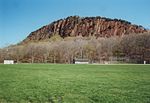
beverages are prohibited. A number of hiking trails traverse the ridge, most notably the Giant Steps Trail which ascends to the summit at a near-vertical...
6 KB (661 words) - 21:09, 18 June 2024

Lillinonah Trail Mattabesett Trail Menunkatuck Trail Metacomet Trail Narragansett Trail Natchaug Trail Naugatuck Trail Nehantic Trail Nipmuck Trail Paugussett...
4 KB (290 words) - 21:48, 15 September 2024
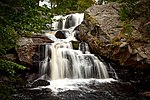
stone formation. The Vista Point cliff, located at the end of the Orange Trail, stands 150 to 175 feet (53 m) above the Eightmile River. Other attractions...
6 KB (582 words) - 21:24, 15 September 2024

The Pachaug Trail is a 28-mile (45 km) Connecticut hiking trail and is one of the Blue-Blazed hiking trails maintained by the Connecticut Forest and Park...
14 KB (1,805 words) - 23:21, 30 December 2023

State Park Trail is a rail trail and linear state park located in Connecticut. The trail is divided into sections designated South (a 25-mile trail from East...
35 KB (2,902 words) - 21:54, 8 September 2024