
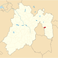
called San José de la Palma, Municipio de Ixtapaluca, was built in 1989. The municipality is bordered by Chalco, Valle de Chalco Solidaridad, Chicoloapan...
8 KB (529 words) - 18:47, 14 April 2025

municipalities: Chimalhuacán, Chicoloapan, Ixtapaluca, Chalco de Solidaridad. It is largely rural. Chicoloapan Ixtapaluca Regiones y Municipios COPLADEM v t e...
775 bytes (55 words) - 04:02, 7 March 2025

State of Mexico (redirect from Estado de Mexico)
Ecatepec de Morelos Nezahualcóyotl Naucalpan de Juárez Toluca Tlalnepantla de Baz Chimalhuacán Cuautitlán Izcalli Atizapán de Zaragoza Tultitlán Ixtapaluca Nicolás...
77 KB (7,760 words) - 08:59, 9 April 2025
municipality borders the municipalities of Ixtapaluca, Chicoloapan, Los Reyes Acaquilpan, al oriente con Chalco de Díaz Covarrubias and borders to the south...
6 KB (654 words) - 20:27, 21 March 2025

Financiero. Retrieved 2020-12-30. Silvia Hernández (2011-02-02). "Bacalar, el décimo municipio de Q. Roo" (in Spanish). El Universal. Retrieved 2011-02-05....
17 KB (153 words) - 21:30, 16 January 2024
"Enciclopedia de los Municipios de México". Archived from the original on 2007-05-23. Retrieved 2008-12-10. "Gobierno del Estado de Aguascalientes"...
110 KB (1,949 words) - 08:08, 22 February 2025

Tepetlaoxtoc, Papalotla, Chiautla, Chiconcuac, Chimalhuacán, Chicoloapan, Ixtapaluca, Ciudad Nezahualcóyotl, Ecatepec as well as the states of Tlaxcala and...
43 KB (4,250 words) - 20:49, 1 April 2025
population of 253,845. It borders with Chicoloapan, Chimalhuacán, Ixtapaluca, Valle de Chalco Solidaridad, Nezahualcoyotl and the Distrito Federal, specifically...
10 KB (659 words) - 17:58, 21 February 2025

Cuautla, Morelos (redirect from Cuautla de Morelos)
115 north to Tetelcingo-Tepetlixpa-Atlatlahucan-Mexico City-Ixtapaluca; east to Izucar de Matamoros (co-signed with #160) Public transportation Local...
46 KB (4,483 words) - 20:05, 16 January 2025
Soriana (redirect from Organizacion Soriana, S.A.B. de C.V.)
addition to opening its first hypermarkets in the State of Mexico with the Ixtapaluca, Cofradías (in the metropolitan area of Mexico City) and Plaza Sendero...
90 KB (10,844 words) - 13:30, 18 February 2025

includes part of the world's largest shanty town, along with Chalco and Ixtapaluca. Most of its population is poor and have migrated from other parts of...
46 KB (4,818 words) - 17:07, 14 April 2025
Tlalmanalco (redirect from Tlalmanalco (municipio))
codices. The municipality is bordered by the municipalities of Chalco, Ixtapaluca, Cocotitlan, Temamatla, Tenango del Aire, Ayapango and Amecameca. It also...
19 KB (1,823 words) - 02:57, 25 October 2024

Chicoloapan, Ecatzingo, Ixtapaluca, Juchitepec, Ozumba, Temamatla, Tenango del Aire, Tepetlixpa and Tlalmanalco, with its head town at Chalco de Díaz Covarrubias...
17 KB (909 words) - 22:38, 4 March 2025
org/web/20131031113048/http://centrodedescargas.cnig.es/CentroDescargas/equipamiento/BD_Municipios-Entidades.zip. Archived from the original on 2013-10-31. Retrieved 2021-01-09...
24 KB (183 words) - 14:52, 13 December 2024
federales y municipios". Instituto Electoral del Estado de México. 31 October 2023. Retrieved 8 January 2025. "Distrito electoral federal 12: Ixtapaluca" (PDF)...
16 KB (884 words) - 02:54, 4 February 2025
Nacional de Información Municipal" (in Spanish). SEGOB. 2010. Retrieved 4 November 2017. "San José del Rincón". Enciclopedia de los Municipios y Delegaciones...
10 KB (676 words) - 18:48, 23 November 2024
eastern portion of Ixtapaluca. The head town was at Amecameca de Juárez. 2005–2017 A portion of the municipality of Naucalpan de Juárez. 1996–2005 The...
18 KB (1,037 words) - 22:37, 4 March 2025