
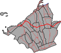
National Route 402 (N402) forms part of the Philippine highway network. It runs through the rural municipalities of Cavite. N402 covers the Tanza to Tagaytay...
9 KB (412 words) - 10:58, 4 July 2023

The highway is designated as a component part of National Route 64 (N64) and National Route 402 (N402) of the Philippine highway network. The highway was...
9 KB (583 words) - 10:37, 24 January 2024
The Philippine highway network is a network of national roads owned and maintained by the Department of Public Works and Highways (DPWH) and organized...
109 KB (869 words) - 03:37, 4 June 2024

Radial Road 1 (section Antero Soriano Highway)
until it meets Antero Soriano Highway at the intersection with Tirona Highway. R-1 is known as the Antero Soriano Highway from the Covelandia Road's terminus...
4 KB (307 words) - 12:31, 4 July 2024

of Covelandia Road, Tirona Highway and Antero Soriano Highway. The second southern terminus is an exit-only to Tirona Highway in Barangay Marulas. The expressway...
35 KB (3,383 words) - 15:12, 3 July 2024
Ternate, Cavite as Governor's Drive. It starts at the intersection with N402, specifically the Naic–Indang Road and Capt. C. Nazareno Street in Barangay...
3 KB (245 words) - 09:57, 28 January 2023
lane, 58.3-kilometer (36.2 mi) network of primary, secondary and tertiary highways and bridges traversing through the central cities and municipalities of...
17 KB (945 words) - 05:55, 18 May 2024

The Tagaytay–Nasugbu Highway, alternatively known as Tagaytay–Nasugbu Road and formerly as Tagaytay–Tuy–Nasugbu Port Road, is a 43.86-kilometer (27.25 mi)...
11 KB (575 words) - 08:21, 3 March 2024
N401 commences at the junction with Magdiwang Highway and Manila–Cavite Road, both components of N402, and General Antonio Street in Noveleta as Marseilla...
4 KB (222 words) - 00:29, 18 August 2023

capital city of Manila, only 59 kilometers (37 mi) away via Aguinaldo Highway, providing an easy escape for the locals from the heat of the huge metropolis...
32 KB (2,626 words) - 13:47, 2 July 2024
National Route 410 (N410) forms part of the Philippine highway network. It runs from southern Cavite to Batangas. N410 starts at the boundary of Silang...
6 KB (194 words) - 02:01, 29 June 2023

National Route 403 (N403) forms part of the Philippine highway network. It runs through central Cavite. It connects the city of Trece Martires to the...
4 KB (204 words) - 00:29, 18 August 2023

National Route 64 (N64) forms part of the Philippine highway network. It runs through northern Cavite. The northern section of N64 forms a physical continuation...
3 KB (167 words) - 02:14, 24 October 2023

Martires Road (or Tanza–Trece Martires Highway) is a 12.559-kilometer (7.804 mi), two-to-four lane, primary highway in Cavite, Philippines. It connects the...
3 KB (99 words) - 01:51, 8 August 2021
Trece Martires–Indang Road (redirect from N404 highway (Philippines))
Mendez-Buna-Indang Road. It ends at the Y-intersection with Indang–Mendez Road (N402). The entire route is located in Cavite. Intersections are numbered by kilometer...
4 KB (266 words) - 08:19, 10 September 2023

respectively. Its section between the Alfonso poblacion and Tagaytay–Nasugbu Highway is also known as Luksuhin–Mangas Road and Mangas–Alfonso Road. The entire...
4 KB (137 words) - 08:34, 27 May 2021