
following outline is provided as an overview of and topical guide to Cornwall: Cornwall – ceremonial county and unitary authority area of England within...
31 KB (2,646 words) - 13:38, 5 August 2024

Carne is a hamlet in the civil parish of St Anthony-in-Meneage, Cornwall, England, UK. Carne lies on the south side of Gillan Creek at around 30 feet (9.1 m)...
955 bytes (95 words) - 16:43, 31 December 2022
Duke of Cornwall (Cornish: Duk a Gernow) is a title in the Peerage of England, traditionally held by the eldest son of the reigning British monarch, previously...
26 KB (1,796 words) - 02:31, 30 September 2024

Church of England Primary School. Christianity in Cornwall Index of Cornwall-related articles Outline of Cornwall – overview of the wide range of topics...
143 KB (13,608 words) - 18:25, 10 October 2024

is a village near Saltash in Cornwall, England. Forder viaduct was formerly at Milepost 252.25, 1.25 miles (2.0 km) west of Saltash (50°23′42″N 4°13′52″W...
2 KB (195 words) - 19:40, 1 October 2024
Salem is a hamlet west of Chacewater, Cornwall, England. Cornwall portal Ordnance Survey One-inch Map of Great Britain; Truro and Falmouth, sheet 190...
826 bytes (28 words) - 18:10, 29 January 2024

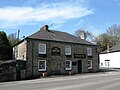
(Cornish: Menyon) is a village in Cornwall, England, United Kingdom. It is situated on the eastern flank of Bodmin Moor northwest of Caradon Hill approximately...
7 KB (705 words) - 13:02, 12 June 2024

the south coast of Cornwall, England, in the civil parish of St Austell Bay. It is situated approximately 2 miles (3 km) southeast of St Austell town...
16 KB (1,923 words) - 19:34, 20 June 2024
with a harbour on the south coast of Cornwall, England, United Kingdom. The village is situated in the civil parish of Tywardreath and Par, although West...
13 KB (1,726 words) - 23:45, 7 July 2024

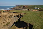
court') in Cornwall is at the southern tip of the Lizard Peninsula. It is situated half-a-mile (800 m) south of Lizard village in the civil parish of Landewednack...
10 KB (897 words) - 11:14, 13 July 2024

Cape Cornwall (Cornish: Kilgoodh, meaning "goose back") is a small headland in West Cornwall, England. It is 4 miles (6.4 km) north of Land's End near...
6 KB (535 words) - 20:53, 27 July 2024

in Cornwall, England, United Kingdom. It is opposite Padstow on the north-east bank of the River Camel estuary. The village is in the civil parish of St...
9 KB (784 words) - 11:24, 8 August 2024
north Cornwall, England, United Kingdom. It is situated one mile (1.6 km) northeast of Bude at grid reference SS 205 075 in the civil parish of Bude-Stratton...
2 KB (188 words) - 21:36, 12 October 2023
Clubworthy (category Hamlets in Cornwall)
is a hamlet in east Cornwall, England, United Kingdom. It is located six miles (8.5 km) north-northwest of Launceston . Cornwall portal Ordnance Survey:...
559 bytes (59 words) - 09:16, 23 April 2022
Coombe, Camborne (redirect from Coombe, Camborne, Cornwall)
a hamlet in west Cornwall, England, United Kingdom. It is situated two miles (3 km) north of the town of Camborne in the valley of the Red River at grid...
732 bytes (75 words) - 23:09, 1 November 2022

civil parish, north of Bude in Cornwall, England, United Kingdom. OS grid reference is SS2214. Shop lies within the Cornwall Area of Outstanding Natural...
704 bytes (49 words) - 17:26, 30 August 2024

is a hamlet in the civil parish of Lostwithiel, in Cornwall, England situated about 1 km south of Lanhydrock. Cornwall portal Ordnance Survey: Landranger...
1 KB (42 words) - 16:38, 18 June 2024

Saint Piran's Flag (redirect from Flag of Cornwall)
Burgee of Penzance Sailing Club Burgee of Port Navas Yacht Club Cornwall portal Outline of Cornwall List of Cornish flags Cornish heraldry The Flag of the...
12 KB (1,168 words) - 01:12, 4 September 2024

civil parish and port in Cornwall, England, United Kingdom. The town lies north of Penzance and west of Camborne on the coast of the Celtic Sea. In former...
59 KB (6,539 words) - 09:27, 14 September 2024

a village in mid Cornwall, England, United Kingdom. It is in the parish of Treverbyn and is situated about five miles (8 km) north of St Austell on the...
4 KB (403 words) - 17:19, 12 April 2024
Coombe, Gwennap (redirect from Coombe, Redruth, Cornwall)
Gwennap civil parish, Cornwall, England, United Kingdom. It is situated approximately three-and-a-half miles (6 km) southeast of Redruth at grid reference...
885 bytes (88 words) - 00:07, 7 November 2022
Fog, meaning blowing house or furnace) is a hamlet in the parish of St Day, Cornwall, England. At Vogue there was a mine called Wheal an Vogue alias Wheal...
3 KB (303 words) - 08:25, 4 October 2023
Mulberry is a hamlet in the parish of Lanivet, Cornwall, England. Cornwall portal Ordnance Survey: Landranger map sheet 200 Newquay & Bodmin (Map). Ordnance...
633 bytes (54 words) - 07:57, 23 March 2022

Tintagel (redirect from Tintagel, Cornwall, England)
Mountain) is a civil parish and village situated on the Atlantic coast of Cornwall, England, United Kingdom. The village and nearby Tintagel Castle are...
47 KB (5,897 words) - 05:34, 10 October 2024
Coombe, Liskeard (redirect from Coombe, Liskeard, Cornwall)
(Cornish: Komm) is a settlement in Cornwall, England, United Kingdom. It is situated one mile (1.6 km) southwest of Liskeard. Coombe Junction Halt is a...
845 bytes (82 words) - 19:44, 24 April 2022

parish of St Anthony-in-Meneage, Cornwall, England. Gillan Creek is one of the creeks of the Helford River. Gillan lies within the Cornwall Area of Outstanding...
867 bytes (80 words) - 09:24, 23 April 2022

in the parish of St Ive and Pensilva in east Cornwall, England, UK. 50°29′24″N 4°23′13″W / 50.49°N 4.387°W / 50.49; -4.387 Cornwall portal Ordnance...
533 bytes (54 words) - 09:24, 23 April 2022

is a hamlet southwest of Bodmin, Cornwall, England, United Kingdom. From the Middle Ages until 1805 St Lawrence was the site of a lazar house (an institution...
789 bytes (78 words) - 17:41, 6 May 2020

Cocks is a hamlet in the parish of Perranzabuloe in Cornwall, England. Cocks is southeast of Perranporth. Ordnance Survey: Landranger map sheet 200 Newquay...
1 KB (76 words) - 12:21, 27 September 2023

hamlet in the parish of Pelynt in southeast Cornwall, England, UK. Barcelona (grid reference SX 219 536) is a hamlet, in southeast Cornwall, on the A387 road...
3 KB (288 words) - 16:48, 22 September 2024