
São Simão is a municipality in south-central Goiás state, Brazil. São Simão is strategically situated on the border of Goiás with Minas Gerais, which makes...
9 KB (944 words) - 18:27, 20 February 2022
Simão (footballer, born 1984), Brazilian football attacking midfielder Pinda Simão (born 1949), Angolan politician São Simão, Goiás, Brazil São Simão...
2 KB (217 words) - 21:22, 13 December 2023

Goiás (Brazilian Portuguese: [ɡo(j)ˈjas] ) is a Brazilian state located in the Midwest region. Goiás borders the Federal District and the states of (from...
45 KB (3,921 words) - 05:01, 19 December 2024
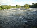
The São Simão Dam is an embankment dam on the Paranaíba River near São Simão in Goiás/Minas Gerais, Brazil. It was constructed for hydroelectric power...
4 KB (247 words) - 06:10, 21 December 2024

Goiás (also known as Goiás Velho, Old Goiás) is a municipality in the state of Goiás in Brazil. Its population was 22,381 (2020 est.) and its area is 3...
19 KB (1,380 words) - 04:22, 11 June 2024

highway that begins in Montes Claros, Minas Gerais and ends in São Simão in the state of Goiás. The highway is duplicated in a few parts near Uberlândia....
4 KB (221 words) - 04:35, 21 September 2023

Paranaíba River (category Rivers of Goiás)
ecological losses in Brazil was the disappearance of the Sâo Simão Channel (Canal de São Simão) located on the lower stretch of the river. It was a narrow...
12 KB (1,337 words) - 19:01, 12 February 2024

São Luís de Montes Belos (also written São Luis de Montes Belos) is a municipality in the State of Goiás, Brazil. It is located in the Anicuns Microregion...
6 KB (618 words) - 18:27, 20 February 2022

Tietê River (category Rivers of São Paulo (state))
100 kilometres (680 mi) between Conchas on the River Tietê (São Paulo) and São Simão (Goiás), on the Paranaíba River and then, up to ltaipu, attaining...
12 KB (1,000 words) - 00:23, 15 December 2024

Anápolis (redirect from Anápolis, Goiás)
Campo Limpo de Goiás, Gameleira de Goiás, Goianápolis, Leopoldo de Bulhões, Nerópolis, Pirenópolis, Silvânia and Terezópolis de Goiás. Anápolis is also...
19 KB (1,885 words) - 22:41, 1 December 2024

built in the state of Goiás. Ceres is 187 km. from the state capital, Goiânia. Municipal boundaries are with Itapaci, Nova Glória, São Patrício, Carmo do...
7 KB (590 words) - 04:22, 16 December 2024

Alto Paraíso de Goiás, usually referred to as Alto Paraíso, is a municipality located in the northeastern region of the state of Goiás, Brazil. The city...
15 KB (1,630 words) - 13:49, 20 August 2023

Paranaiguara (category Municipalities in Goiás)
There are municipal boundaries with: north: Quirinópolis south: São Simão east: São Simão and Santa Vitória, Minas Gerais west: Cachoeira Alta and Caçu...
6 KB (417 words) - 18:27, 20 February 2022
Vicente do Espirito Santo (category Roman Catholic bishops of Goiás)
of São Tomé e Príncipe and shortly after was appointed by Pope Pius VI as the first Prelate of Goiás on 17 Dec 1782. He served as Prelate of Goiás until...
5 KB (278 words) - 00:47, 29 August 2023
Claro River (Paranaíba River tributary) (category Rivers of Goiás)
of Goiás state in central Brazil. It is a tributary of the Paranaíba River, which it enters just downriver of São Simão Dam. List of rivers of Goiás Tributaries...
1 KB (83 words) - 13:51, 17 February 2023

Minas Gerais and, later, to Mato Grosso and Goiás. As a consequence, in 1709, São Paulo substituted São Vicente as the administrative seat of the captaincy...
67 KB (7,910 words) - 14:30, 23 August 2024

concession contract, signed in Goiás on July 31, 2019. On March 4, 2021, Rumo launched operations on the stretch between São Simão (GO) and Estrela d'Oeste...
40 KB (3,579 words) - 04:23, 9 August 2024

/ São João d'Aliança / Alto Paraíso de Goiás / BR-010 / GO-118 / Teresina de Goiás / Monte Alegre de Goiás / GO-447 / Vazante / Divinópolis de Goiás /...
7 KB (580 words) - 18:27, 20 February 2022
Alagoinhas Referee: Thiago Luís Scarascati (São Paulo) 22 February 2023 16:00 Batistão, Aracaju Referee: Léo Simão Holanda (Ceará) 28 February 2023 20:00 Estádio...
37 KB (1,056 words) - 09:00, 20 January 2024

Bela Vista de Goiás is a city located in central Goiás state in Brazil. It is 45 kilometers from the state capital of Goiânia The municipality has boundaries...
6 KB (500 words) - 18:27, 20 February 2022

Teresina de Goiás Defect Boys is a municipality in northern Goiás state, Brazil. It is part of the region of the statistical micro-region of Chapada dos...
5 KB (309 words) - 20:08, 14 December 2022

São Francisco de Goiás is a municipality in central Goiás state, Brazil. Municipal boundaries: North: Jaraguá South: Petrolina de Goiás East: Pirenópolis...
6 KB (475 words) - 18:27, 20 February 2022

Fria de Goiás is a municipality in northern Goiás state, Brazil. Água Fria became a city in 1989 when it was dismembered from Planaltina de Goiás in 1989...
6 KB (473 words) - 18:46, 26 July 2024

São João d'Aliança is a municipality in northeastern Goiás state, Brazil. São João is a gateway to the Chapada dos Veadeiros National Park. The name is...
5 KB (455 words) - 18:27, 20 February 2022

São João da Paraúna is a municipality in western Goiás state, Brazil. São João is located west of Goiânia, 36 km. north of Paraúna. Highway connections...
5 KB (272 words) - 16:17, 26 August 2024
v São Paulo São Paulo v Fluminense São Paulo v Portuguesa Goiás v São Paulo São Paulo v Vasco da Gama São Paulo v Botafogo Paysandu v São Paulo São Paulo...
46 KB (441 words) - 23:43, 12 December 2024

Rio dos Bois (Paranaíba River tributary) (category Rivers of Goiás)
The Rio dos Bois is a river of Goiás state in central Brazil. It flows into the São Simão reservoir, which is fed and drained by the Paranaíba River, near...
924 bytes (43 words) - 13:40, 17 February 2023

of Goiás see Seplan Goianésia, Itaguari, Itaguaru, Jesúpolis, Pirenópolis, Rianápolis, Santa Isabel, Santa Rosa de Goiás, São Francisco de Goiás, Taquaral...
7 KB (694 words) - 23:52, 25 June 2022
Luiz de Freitas Castro (Goiás) 6 February 2019 22:15 Lacerdão, Caruaru Attendance: 5,964 Referee: Leandro Bizzio Marinho (São Paulo) 6 February 2019 20:30...
43 KB (1,122 words) - 21:01, 23 October 2022

Santa Cruz de Goiás is a municipality in southeast Goiás state, Brazil. Santa Cruz is located in the southeastern part of the state, 33 km. west of regional...
6 KB (531 words) - 18:27, 20 February 2022