
The Shire of Barcoo is a local government area in Central West Queensland, Australia. It covers an area of 61,830 square kilometres (23,872.7 sq mi), and...
8 KB (607 words) - 16:15, 21 July 2024

town and locality in the Shire of Barcoo, Queensland, Australia. In the 2021 census, the locality of Stonehenge had a population of 58 people. Stonehenge...
8 KB (578 words) - 00:01, 10 July 2024

Jundah, Queensland (category Shire of Barcoo)
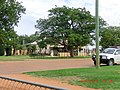
rural town and locality in the Shire of Barcoo, Queensland, Australia. Jundah is the administrative centre of the Barcoo Shire local government area. In the...
13 KB (996 words) - 03:05, 14 June 2024
Barcoo may refer to: Shire of Barcoo, a local government area in Queensland, Australia Electoral district of Barcoo, Queensland, Australia Barcoo River...
788 bytes (127 words) - 01:01, 7 June 2022
Windorah (category Shire of Barcoo)
a town and a locality in the Shire of Barcoo, Queensland, Australia. It is one of only three towns in the Shire of Barcoo in Central West Queensland. In...
28 KB (2,155 words) - 05:22, 14 August 2024

Division of Maranoa and the Division of Kennedy. Local government areas included in the region are Shire of Barcoo, Shire of Diamantina, Shire of Boulia...
10 KB (837 words) - 11:57, 7 March 2024
Arrabury Airport (category Shire of Barcoo)
an airport at Arrabury pastoral station in Tanbar, Shire of Barcoo, Queensland, Australia. List of airports in Queensland YARY – Arrabury (PDF). AIP En...
2 KB (61 words) - 16:20, 17 December 2023

Farrars Creek, Queensland (category Shire of Barcoo)
Farrars Creek is an rural locality in the Shire of Barcoo, Queensland, Australia. In the 2021 census, Farrars Creek had "no people or a very low population"...
4 KB (328 words) - 07:11, 7 July 2024

Tanbar, Queensland (category Shire of Barcoo)
coordinates) Tanbar is an outback locality in the Shire of Barcoo, Queensland, Australia. It is on the corner of Queensland's southern and western border with...
8 KB (766 words) - 08:55, 30 May 2024
Canterbury, Queensland (category Shire of Barcoo)
Canterbury is a small abandoned settlement in the locality of Windorah in Shire of Barcoo in Central West Queensland, Australia. The JC Hotel Ruins are...
4 KB (231 words) - 00:37, 26 June 2024
Windorah Airport (category Shire of Barcoo)
airport serving Windorah, Queensland, Australia. It is operated by the Barcoo Shire Council. The airport received $183,578 in funds for security upgrades...
3 KB (159 words) - 09:57, 23 July 2023

Queensland, see List of former local government areas of Queensland. Queensland portal List of former local government areas of Queensland List of places in Queensland...
28 KB (185 words) - 09:12, 8 August 2024
Kungkari language (redirect from Kuungkari language of Barcoo River)
local government boundaries of the Longreach Shire Council and Blackall-Tambo Shire Council. Geographically it lay near the Barcoo River between the Karnic...
4 KB (278 words) - 06:09, 5 December 2023

Welford Homestead (category Shire of Barcoo)
a heritage-listed homestead in the Welford National Park, Jundah, Shire of Barcoo, Queensland, Australia. It was added to the Queensland Heritage Register...
6 KB (610 words) - 03:12, 24 May 2021
Queensland, Australia Tanbar, Queensland, an outback locality in the Shire of Barcoo, Queensland, Australia This disambiguation page lists articles associated...
207 bytes (55 words) - 08:56, 29 July 2021

Haddon Corner (category Shire of Barcoo)
Haddon Corner is a heritage-listed site in Tanbar, Shire of Barcoo, Queensland, Australia. It is in outback Channel Country at South-West Queensland,...
27 KB (3,565 words) - 09:22, 2 July 2024

councillors. No wards or electoral divisions existed. The Barcoo River passes through the shire's former area and the dominant industry is sheep and cattle...
6 KB (596 words) - 04:11, 27 January 2023

Banana mobile library (Shire of Banana) Barcaldine Regional Council Libraries (Barcaldine Region) Barcoo Shire Libraries (Shire of Barcoo) Blackall Municipal...
29 KB (1,980 words) - 01:00, 14 August 2024
areas: Shire of Banana Shire of Barcaldine Shire of Barcoo Blackall-Tambo Region Shire of Boulia Central Highlands Region Shire of Diamantina Gladstone...
127 KB (3,710 words) - 07:14, 29 August 2024

cattle station in Tanbar, Shire of Barcoo, Queensland, Australia. It is located approximately 87 kilometres (54 mi) south west of Windorah and 240 kilometres...
6 KB (550 words) - 12:34, 7 August 2023

Windorah Solar Farm (category Shire of Barcoo)
Farm was Ergon Energy's first solar farm trial near the town of Windorah in the Shire of Barcoo, Queensland, Australia. The plant used five concentrated solar...
7 KB (487 words) - 00:05, 9 May 2024

The Shire was created on 17 July 1930 from parts of the Shires of Barcoo, Murweh and Paroo and part of the abolished Shire of Adavale and all of the abolished...
8 KB (545 words) - 01:36, 28 June 2024
Haddon County, Queensland (category Counties of Queensland)
(620 mi) west of the state capital, Brisbane. "Haddon – county in the Shire of Barcoo (entry 15171)". Queensland Place Names. Queensland Government. Retrieved...
3 KB (253 words) - 06:00, 22 December 2022

rains. The Barcoo River forms the boundary of outback Australia with little in the way of civilization west of the Barcoo. Waters from the Barcoo and Alice...
5 KB (386 words) - 23:19, 7 June 2022

divisions existed. The Barcoo River travels through the shire's former area on its way to Cooper Creek and eventually Lake Eyre. Like much of the west, sheep...
5 KB (363 words) - 17:11, 31 December 2020

The Shire of Burdekin is a local government area located in North Queensland, Australia in the Dry Tropics region. The district is located between Townsville...
15 KB (787 words) - 23:54, 21 June 2024
Tanbar County, Queensland (category Counties of Queensland)
Tanbar County, Queensland is a cadastral division of Queensland and a county of the South Gregory District of far western Queensland. The county came into...
3 KB (176 words) - 07:07, 6 August 2024

The Shire of Etheridge is a local government area in Far North Queensland, Australia in what is known as the Savannah Gulf region. Its economy is based...
9 KB (600 words) - 00:50, 22 June 2024

its region split between the new Shire of Quilpie, the Shire of Murweh, the Shire of Isisford and the Shire of Barcoo. 1888 A. B. Learmouth 1899 Augustus...
5 KB (397 words) - 16:29, 18 July 2024

Yaraka (category Lists of coordinates)
Government. Retrieved 16 October 2020. "Fort Douglas – mountain in the Shire of Barcoo (entry 12928)". Queensland Place Names. Queensland Government. Retrieved...
23 KB (2,256 words) - 02:15, 20 June 2024