
Moira Shire Council is a Local Government Area in the Northern Victoria Region of Victoria, Australia. Located in the north-east part of the state, it...
9 KB (453 words) - 18:52, 10 February 2024
Shire of Moira, a local government area in Victoria, Australia Moira, Ontario, an unincorporated area Moira Lake, Ontario Moira River, Ontario Moira,...
2 KB (286 words) - 19:45, 26 July 2024

Creek, Wakiti) • Lake Rowan (1875–1981 Calder's, Pelluebla South) • Lower Moira (1902–1953 Madowla Park) • Marungi (1879–1971) • Muckatah (1881–1920)...
136 KB (12,146 words) - 05:09, 28 June 2024

Yarrawonga (category Shire of Moira)
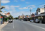
town in the Shire of Moira local government area in the Australian state of Victoria. In the 2021 census, Yarrawonga had a population of 8,661 people...
13 KB (968 words) - 22:35, 7 June 2024

The Division of Nicholls is an Australian Electoral Division in the state of Victoria, which was contested for the first time at the 2019 federal election...
5 KB (353 words) - 14:06, 26 April 2024
Cobram (category Shire of Moira)
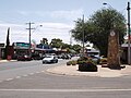
the nearby towns of Numurkah and Yarrawonga is part of Shire of Moira and is the administrative centre of the council. Its twin town of Barooga is located...
28 KB (2,668 words) - 12:42, 26 September 2024

of the Hume region in north eastern Victoria. It includes the municipalities of City of Greater Shepparton, Shire of Mitchell, Shire of Moira, Shire of...
1 KB (49 words) - 04:31, 7 May 2024

a shire and is governed by a shire council. Local councils have the same administrative functions and similar political structures, regardless of their...
39 KB (321 words) - 18:51, 26 September 2024

Nathalia, Victoria (category Shire of Moira)
Shire of Moira local government area on the banks of Broken Creek and on the Murray Valley Highway. At the 2021 census, Nathalia had a population of 1...
7 KB (693 words) - 10:05, 7 May 2023

Strathmerton (category Shire of Moira)
located in the Shire of Moira local government area on the Murray Valley Highway and Goulburn Valley Highway, about 11 kilometres (7 mi) west of Cobram. At...
6 KB (411 words) - 23:04, 3 July 2023

Goulburn Valley Highway (category Shire of Moira)
Victoria to Eildon. The section north of the Hume Freeway (part of which is Goulburn Valley Freeway) is part of the Melbourne to Brisbane National Highway...
32 KB (2,326 words) - 02:48, 15 July 2024
Numurkah (category Shire of Moira)
Highway, 37 kilometres (23 mi) north of Shepparton, in the Shire of Moira. At the 2016 census, Numurkah had a population of 4,768. The area was occupied by...
8 KB (801 words) - 22:31, 23 August 2024

Picola (category Shire of Moira)
Picola is a town in the Shire of Moira in northern Victoria, Australia. At the 2021 census, Picola had a population of 206. The name Picola is thought...
9 KB (658 words) - 20:18, 17 February 2024

Wunghnu (category Shire of Moira)
Valley region of northern Victoria, Australia. The town is located in the Shire of Moira local government area, 204 kilometres (127 mi) north of the state...
5 KB (329 words) - 10:20, 7 May 2023

and other towns in the local government areas of Moira, Wangaratta, and Alpine. The abolished seat of Murray Valley was held by Nationals MP Tim McCurdy...
3 KB (206 words) - 07:45, 25 May 2024

electorates. Section 24 of the Constitution of Australia specifies that the total number of members of the Australian House of Representatives shall be...
40 KB (870 words) - 01:42, 27 September 2024

elect the councils of 78 of the 79 local government areas (LGAs) in Victoria, Australia. No election will be held for Moira Shire after the council was...
28 KB (1,391 words) - 06:39, 3 October 2024

Tungamah (category Shire of Moira)
a town in the Goulburn Valley region of northern Victoria, Australia. The town is located in the Shire of Moira local government area, 259 kilometres...
5 KB (360 words) - 04:09, 27 September 2023

Bundalong, Victoria (category Shire of Moira)
Murray Valley Highway, east of Yarrawonga. At the 2016 census, Bundalong had a population of 428. Bundalong is in the Shire of Moira local government area,...
3 KB (148 words) - 05:48, 11 May 2023

This is a list of places on the Victorian Heritage Register in the Shire of Moira in Victoria, Australia. The Victorian Heritage Register is maintained...
3 KB (63 words) - 19:11, 12 March 2022

Barmah (category Shire of Moira)
is a town in the state of Victoria, Australia. Barmah has the distinction of being located north of the border with the state of New South Wales. New South...
6 KB (581 words) - 04:46, 4 March 2024

Katamatite (category Shire of Moira)
Australia about 46 kilometres north east of Shepparton. At the 2011 census, Katamatite had a population of 433. Katamatite is located in the Murray Valley...
9 KB (806 words) - 07:47, 22 June 2024

district of Shepparton is a rural Lower House electoral district of the Victorian Parliament. It is located within the Northern Victoria Region of the Legislative...
6 KB (302 words) - 15:23, 1 March 2024

Hume (region) (category Regions of Victoria (state))
of Alpine Shire, Rural City of Benalla, City of Wodonga, City of Greater Shepparton, Shire of Indigo, Shire of Mansfield, Shire of Strathbogie, Shire...
17 KB (1,261 words) - 23:43, 18 November 2023

county, on the eastern end of it. It also includes Shepparton. The Shire of Moira is in a similar area. Parishes within the county: Arcadia, Victoria...
4 KB (272 words) - 09:11, 7 May 2023
Telford, Victoria (category Shire of Moira)
Oaklands railway line, Victoria "2016 Telford, Census All persons QuickStats | Australian Bureau of Statistics". abs.gov.au. Retrieved 25 May 2022. v t e...
2 KB (55 words) - 10:15, 7 May 2023
Koonoomoo (category Shire of Moira)
Australia. The town is located in the Shire of Moira local government area, 264 kilometres (164 mi) north of the state capital, Melbourne on the Goulburn...
5 KB (200 words) - 09:58, 7 May 2023

Peechelba (category Shire of Moira)
Rural City of Wangaratta and the Shire of Moira local government area between Wangaratta and Yarrawonga and 277 kilometres (172 mi) north east of the state...
4 KB (354 words) - 04:12, 17 July 2023
Almonds, Victoria (category Shire of Moira)
23 December 1925 and later closed on 24 November 1952. Australian Bureau of Statistics (27 June 2017). "Almonds (State Suburb)". 2016 Census QuickStats...
2 KB (62 words) - 05:41, 11 May 2023

Solar power in Australia (redirect from The History of Solar Power in Australia)
electricity supply in Australia. As of December 2023, Australia's over 3.69 million solar PV installations had a combined capacity of 34.2 GW photovoltaic (PV)...
62 KB (5,360 words) - 03:30, 15 September 2024