
Sorocaba (Portuguese pronunciation: [soɾoˈkabɐ]) is a municipality in the interior of the state of São Paulo, Brazil. With over 723,000 inhabitants, it...
33 KB (3,304 words) - 01:09, 9 August 2024

The Sorocaba River (Portuguese, Rio Sorocaba) is a river of São Paulo state in southeastern Brazil. It is a tributary of the Tietê River. The river runs...
5 KB (523 words) - 13:50, 17 February 2023

Metropolitan Region of Sorocaba. The population is 37,964 (2020 est.) in an area of 170.29 km². The elevation is 590 m. The Sorocaba River flows near Iperó...
5 KB (213 words) - 00:29, 14 June 2024

River Cotia River Dourado River Jacaré-Guaçu River Jacaré-Pepira River Jaú River Jundiaí River Piracicaba River São Lourenço River Sorocaba River 20°37′40″S...
12 KB (1,000 words) - 17:54, 10 August 2024
Baltasar Fernandes (category People from Sorocaba)
slaves, founded the city of Sorocaba on 15 August 1654. Around 1654, Fernandes built a house on the edge of the Sorocaba River and a chapel—Nossa Senhora...
6 KB (580 words) - 13:55, 13 August 2024
Sarapuí River is a river of São Paulo state in southeastern Brazil. It is a tributary of the Sorocaba River, which flows into the Tietê River, an important...
955 bytes (44 words) - 15:33, 5 January 2020
The Itupararanga Dam is a dam, located on the Sorocaba River in the Sorocaba region of São Paulo state. It was built by Light S.A. from 1913 to 1914. The...
3 KB (239 words) - 12:38, 11 January 2024

River Soé River Sombrio River (Brazil) Do Sono River (Minas Gerais) Do Sono River (Tocantins) Sorocaba River Sororò River Sotério River Soturno River...
59 KB (6,576 words) - 08:18, 24 January 2024

The Tatuí River is a river of São Paulo state in southeastern Brazil. List of rivers of São Paulo Brazilian Ministry of Transport v t e...
862 bytes (26 words) - 23:08, 4 January 2020
the cities of Votorantim and Sorocaba, state of São Paulo, Brazil. The origin of the name dates from the founding of Sorocaba 1654 by Baltasar Fernandes...
6 KB (874 words) - 13:28, 9 March 2021
The Guarapó River is a river of São Paulo state in southeastern Brazil. List of rivers of São Paulo Brazilian Ministry of Transport v t e...
918 bytes (26 words) - 16:09, 21 April 2022
River Sorocaba River Guarapó River Tatuí River Sarapuí River Avecutá River Jundiaí River Jundiuvira River Juqueri River Cotia River Pinheiros River (Jurabatuba...
12 KB (779 words) - 12:47, 13 March 2023

Barrella, Walter (September 2003). "The fish fauna in tropical rivers: The case of the Sorocaba river basin, SP, Brazil". Revista de Biología Tropical. 52 (3)...
48 KB (5,498 words) - 01:49, 16 July 2024
"bad water". Ipanema Hill is located in Sorocaba River Watershed, between the left bank tributaries, the rivers Sarapuí and Ipanema, has an altitude of...
5 KB (732 words) - 00:34, 22 December 2023
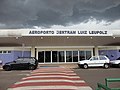
Bertram Luiz Leupolz Airport (IATA: SOD, ICAO: SDCO) is the airport serving Sorocaba, Brazil. It is operated by Rede Voa. The airport was commissioned in 1942...
4 KB (253 words) - 13:01, 22 April 2024

Municipal Zoological Park Quinzinho de Barros (category Sorocaba)
"Quinzinho de Barros" (the City Zoo of Sorocaba) is a 15-hectare (37-acre) zoo located in the municipality of Sorocaba, state of São Paulo, Brazil. It is...
7 KB (774 words) - 17:10, 28 February 2022

Metropolitan Region of Sorocaba. The population is 119,736 (2020 est.) in an area of 133.06 km². The elevation is 555 m. The city has one main river, rio Tietê....
4 KB (191 words) - 18:19, 27 May 2024

Brazilian Portuguese). Prefeitura de Itu. "History of the City of Sorocaba". Municipality of Sorocaba. Wikimedia Commons has media related to Suzana Dias....
4 KB (294 words) - 23:25, 20 August 2024

area, with its inhabitants being transferred to the Itavuvu region, where Sorocaba is today, in 1611, by order of the governor-general of Brazil D. Francisco...
99 KB (10,178 words) - 03:11, 21 August 2024

List of tributaries of the Río de la Plata (category Lists of river tributaries)
Laras Dam Sorocaba River: left; BR; 22°58′56″S 47°48′24″W / 22.98222°S 47.80667°W / -22.98222; -47.80667 (Sorocaba River); Rio Sorocaba at GEOnet...
28 KB (4,154 words) - 13:51, 17 February 2023
a highway in the state of São Paulo, connecting the municipalities of Sorocaba (Km 0), Itu, Salto, Indaiatuba (Km 50, 53, 55 and 57) and Campinas (Km...
5 KB (521 words) - 20:28, 8 August 2023

language, originally from the Fulni-ô tribe, arose in reference to a river in the Sorocaba region, and means "turbid water" or "water that can not be used...
12 KB (1,258 words) - 02:15, 9 August 2024

18th century. In 1769 the municipality was created, by separating it from Sorocaba. Named Itapeva da Faxina until 1910 and Faxina until 1938. In Tupi language...
7 KB (339 words) - 15:21, 3 August 2024

(Mackenzie Presbyterian University, Private); Universidade de Sorocaba (UNISO) (University of Sorocaba, Private) Fundação Getúlio Vargas (FGV) (Getúlio Vargas...
182 KB (17,492 words) - 21:40, 20 August 2024

serving the main cities of Cotia, Vargem Grande Paulista, São Roque, Sorocaba, Itapetininga, Angatuba, Ourinhos, Assis, Presidente Prudente, Presidente...
4 KB (178 words) - 15:47, 12 February 2024

(Registro, Itanhaém) 14 – Central (Bauru, Marília, Botucatu) 15 – Southwest (Sorocaba, Itapetininga) 16 – Northeast (Ribeirão Preto, Franca, São Carlos) 17 –...
12 KB (1,264 words) - 23:55, 31 July 2024

located in São Paulo state, Brazil. It is part of the Metropolitan Region of Sorocaba. The population is 122,967 (2020 est.) in an area of 523.75 km2. Known...
9 KB (907 words) - 16:23, 3 July 2024

Paulo via Sorocaba. Abreu Lima reached Porto Feliz on 25 July and Itu on the 27th, without resistance. Franco Ferreira's detachment entered Sorocaba on 23...
60 KB (7,806 words) - 14:06, 13 August 2024

Death Column (section Descent of the river)
the month, they consolidated their strength in the São Paulo-Campinas-Sorocaba triangle and extended to Bauru and Araraquara. The approach of several...
49 KB (6,950 words) - 14:29, 13 August 2024

state of São Paulo in Brazil. It is part of the Metropolitan Region of Sorocaba. The population was 175,568 as of 2020, in an area of 640.72 km2. The elevation...
9 KB (610 words) - 17:31, 27 May 2024