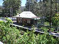
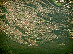
Stanwell Tops is an exurban locality between the cities of Sydney and Wollongong on the New South Wales, Australia coastline. It lies northwest of Stanwell...
13 KB (1,294 words) - 08:10, 30 July 2024

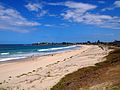
Stanwell Park is a coastal village and northern suburb of Wollongong, New South Wales, Australia. It is the northernmost point of the Illawarra coastal...
14 KB (1,618 words) - 07:34, 30 July 2024
Glamorgan, Wales Stanwell Moor Stanwell Park, New South Wales Stanwell Tops, New South Wales Stanwell Power Station, Stanwell, Queensland Stanwell Corporation...
567 bytes (96 words) - 20:49, 29 May 2018
Shellharbour Village) is a suburb located in the Illawarra region of New South Wales, Australia. It also gives its name to the local government area, City...
8 KB (644 words) - 07:24, 30 July 2024

Dapto is a suburb of Wollongong in the Illawarra region of New South Wales, Australia, located on the western side of Lake Illawarra and covering 7.15...
16 KB (1,715 words) - 03:18, 12 August 2024

town on the south-west fringe of Sydney in the Macarthur Region in Tharawal country near its boundary with Gandangara country, New South Wales, Australia...
26 KB (2,769 words) - 08:16, 21 April 2024
YOU-nən-derr-ə) is a suburb of Wollongong in New South Wales, Australia. It is located approximately 6 km south-west of the Wollongong CBD. It is bordered...
4 KB (400 words) - 14:47, 30 July 2024
Otford is situated in the Otford Valley, north of Undola Ridge, Stanwell Park and Stanwell Tops. To the east of the valley is the coastal ridge and small community...
7 KB (905 words) - 15:14, 29 July 2024

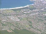
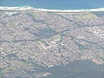
Wollongong (redirect from Woollongong, New South Wales)
Dharawal: Woolyungah) is a city located in the Illawarra region of New South Wales, Australia. The name is believed to originate from the Dharawal language...
74 KB (7,777 words) - 08:13, 26 September 2024

New South Wales State Heritage Register. Department of Planning & Environment. H01269. Retrieved 18 May 2018. Text is licensed by State of New South Wales...
32 KB (4,111 words) - 10:40, 30 July 2024

Coalcliff is a town on the coast of New South Wales, Australia, between Sydney and Wollongong. In 1796 William Clark and others trekking north to Port...
11 KB (1,229 words) - 06:04, 23 July 2024

narrow area separating it from Dapto, and farmland to the north, west and south. West of Horsley is Mount Bong Bong, part of the Illawarra escarpment range...
3 KB (294 words) - 05:47, 25 May 2024

local government areas that comprise the Wollongong Metropolitan Area, New South Wales, Australia. Although it is surrounded by a 'green belt' of farms, Albion...
8 KB (849 words) - 09:47, 20 July 2024

BULL-eye) is a northern suburb of Wollongong situated on the south coast of New South Wales, Australia. Bulli is possibly derived from an Aboriginal word...
12 KB (1,523 words) - 23:56, 26 August 2024

a suburb north of Wollongong, New South Wales, Australia, south of Sydney. It is served by Woonona Station on the South Coast Line, and by the Princes...
7 KB (1,007 words) - 15:57, 30 July 2024

Illawarra region of New South Wales, Australia, in the Municipality of Kiama. It has a station (opened 1891) on the NSW TrainLink South Coast Line. The Minnamurra...
4 KB (351 words) - 13:58, 29 July 2024

generally fairly mild throughout the year, much like the majority of the New South Wales coast. Day temperatures average between 24 °C and 29 °C in the summer...
13 KB (1,383 words) - 07:30, 8 September 2024
of Mount Warrigal in the west, Barrack Heights and Barrack Point in the south and Lake Illawarra in the north. Warilla was officially granted township...
4 KB (310 words) - 15:07, 30 July 2024
Fairy Meadow is a suburb in the City of Wollongong, New South Wales, Australia. Located in the Illawarra region and only 4 km from the city centre, it...
8 KB (965 words) - 20:07, 21 July 2024

Port Kembla is a suburb of Wollongong 10 km south of the CBD and part of the Illawarra region of New South Wales. The suburb comprises a seaport, industrial...
23 KB (2,408 words) - 07:09, 30 July 2024
Warrawong is a suburb of Wollongong in the Illawarra region of New South Wales, Australia. It is situated on the northeast corner of Lake Illawarra. Warrawong...
4 KB (259 words) - 23:42, 22 August 2024
Bald Hill (Australia) (category Tourist attractions in New South Wales)
lookout is by way of Lawrence Hargrave Drive from either Stanwell Tops, Otford or Stanwell Park. There is currently no major track to the lookout, although...
14 KB (1,338 words) - 20:34, 3 April 2024
Balgownie (/bælɡaʊni/) is a small suburb of Wollongong, New South Wales, Australia. Balgownie lies to the north-west of the Wollongong CBD. It stretches...
4 KB (275 words) - 10:26, 20 July 2024
Australia and Broken Hill, an ambitious scheme for treating nickel from New Caledonia came to nothing and in 1905 the works closed. (McDonald, 1976;...
5 KB (666 words) - 12:24, 29 July 2024

Clifton is a village on the coast of New South Wales, Australia, between Sydney and Wollongong. Along with nearby Coalcliff, the village began life as...
6 KB (662 words) - 15:50, 21 July 2024
Corrimal is a suburb north of the city of Wollongong, New South Wales, Australia. Corrimal's CBD is situated on the Princes Highway, and several streets...
8 KB (1,041 words) - 16:06, 21 July 2024
Curramore is a rural locality north of Jamberoo, New South Wales in the Municipality of Kiama. At the 2021 census, it had a population of 220. Australian...
2 KB (60 words) - 16:27, 21 July 2024

beach-side suburb approximately 5 km (3.1 mi) north of Wollongong, New South Wales, Australia. Towradgi is derived from the Dharawal word Kow-radgi, meaning...
7 KB (764 words) - 14:43, 30 July 2024

Saddleback Mountain is a mountain near Kiama in the Illawarra region of New South Wales, Australia. The mountain rises to about 600 metres (2,000 ft) above...
5 KB (506 words) - 09:17, 1 April 2022

Figtree is an inner western suburb of Wollongong, New South Wales, Australia. It is south-west of West Wollongong and connected to Wollongong by the Princes...
7 KB (771 words) - 01:10, 15 August 2024