
The Thompson–Nicola Regional District is a regional district in the Canadian province of British Columbia. The Canada 2021 Census population was 143,680...
23 KB (959 words) - 08:17, 11 August 2024
British Columbia Thompson-Nicola A, British Columbia Thompson-Nicola B, British Columbia Thompson-Nicola E, British Columbia Thompson-Nicola I, British Columbia...
9 KB (821 words) - 21:03, 4 February 2023
replace Kamloops—Thompson—Cariboo. Gains Logan Lake, Merritt, the regional district electoral areas of Thompson-Nicola M (Beautiful Nicola Valley – North)...
13 KB (391 words) - 04:17, 29 April 2025

Kamloops (redirect from Thompson's River Post)
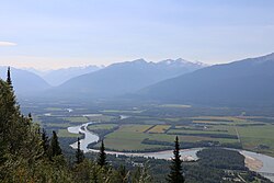
is the administrative centre for, and largest city in, the Thompson-Nicola Regional District, a region of the British Columbia Interior. The city was incorporated...
99 KB (8,536 words) - 23:56, 7 April 2025
Thompson Country and is often referred to separately, or in combination forms, notably the Thompson-Nicola Regional District. The combination Nicola-Similkameen...
3 KB (430 words) - 17:52, 28 May 2023
Okanagan—Similkameen—Merritt (category Former federal electoral districts of British Columbia)
Kootenay Boundary Regional District, the Okanagan-Similkameen Regional District, Electoral Areas M and N of the Thompson-Nicola Regional District, and the city...
3 KB (123 words) - 02:46, 15 February 2025

Brookmere (category Populated places in the Thompson-Nicola Regional District)
Brookmere is an unincorporated community adjacent to Brook Creek in the Nicola region of south central British Columbia, Canada. On Coldwater Rd (exit...
33 KB (2,638 words) - 12:16, 27 November 2024

such as the Thompson-Okanagan or Thompson-Nicola Regional District. Weather forecasts and tourism information refer to the area as Thompson-Shuswap. Although...
6 KB (767 words) - 15:21, 14 October 2024
the Nicola Highway, is an alternate route to Highway 97C between Highway 1 and the Coquihalla Highway (Highway 5) in the Thompson-Nicola Regional District...
9 KB (691 words) - 14:19, 23 April 2025
Okanagan—Similkameen (category Former federal electoral districts of British Columbia)
the Regional District of Kootenay Boundary lying west of the westerly boundary of Electoral Area B part of the Thompson-Nicola Regional District lying...
4 KB (147 words) - 23:56, 13 February 2025
Cariboo—Chilcotin (category Former federal electoral districts of British Columbia)
of: the Cariboo Regional District; the Squamish–Lillooet Regional District; and the part of the Thompson–Nicola Regional District west of Electoral Areas...
8 KB (230 words) - 05:38, 11 February 2025
the Thompson River Thompson Plateau, a landform in the Interior of British Columbia named for the Thompson River Thompson-Nicola Regional District, a regional...
3 KB (334 words) - 01:36, 21 March 2025
Kamloops—Shuswap (category Former federal electoral districts of British Columbia)
Thompson-Nicola Regional District lying east of Electoral Areas E and I and north of Electoral Area M; and the part of the Columbia-Shuswap Regional District...
4 KB (116 words) - 19:19, 11 February 2025

Stump Lake, British Columbia (category Populated places in the Thompson-Nicola Regional District)
the Nicola Country of the South-Central Interior of British Columbia, Canada, located 12 km north of Quilchena, also lies to the northeast of Nicola Lake...
5 KB (90 words) - 01:43, 26 November 2024
Walhachin (category Populated places in the Thompson-Nicola Regional District)
community in the Thompson Country region of south central British Columbia, Canada. The place is on a south shore bench of the Thompson River between Brassey...
57 KB (5,288 words) - 21:48, 9 November 2024

Little Fort (category Populated places in the Thompson-Nicola Regional District)
Little Fort is an unincorporated community in the Thompson region of south central British Columbia. The former ferry site is immediately west of the mouth...
9 KB (744 words) - 00:56, 8 December 2024
Columbia–Shuswap and Thompson–Nicola regional districts to the south and southeast, Cariboo Regional District to the southwest, the Regional District of Bulkley–Nechako...
19 KB (651 words) - 02:37, 18 February 2025
Pinantan Lake (category Populated places in the Thompson-Nicola Regional District)
unincorporated community, encircling the larger lake of the same name, in the Thompson region of south central British Columbia. The locality is by road about...
14 KB (1,030 words) - 10:43, 5 November 2023
"Kamloops, Thompson and Highland Valleys". It consisted of: Electoral Areas A, B, J, L, O and P of the Thompson-Nicola Regional District; The City of...
10 KB (252 words) - 14:55, 8 February 2025
Savona, British Columbia (category Populated places in the Thompson-Nicola Regional District)
TNRD (2003). Cherry Creek Savona Official Community Plan. Thompson-Nicola Regional District. {{cite book}}: |website= ignored (help) Villiers, Edward...
72 KB (5,552 words) - 23:41, 3 February 2025

Lytton, British Columbia (category Populated places in the Thompson-Nicola Regional District)
the east side of the Fraser River and primarily the south side of the Thompson River, where it flows southwesterly into the Fraser. The community includes...
38 KB (2,883 words) - 16:36, 15 November 2024
Bighorn, British Columbia (category Populated places in the Thompson-Nicola Regional District)
Bighorn is an unincorporated settlement and locality in the Thompson Canyon in British Columbia, Canada. It is a few miles south of Spences Bridge, British...
797 bytes (98 words) - 15:08, 8 September 2024
Birch Island, British Columbia (category Populated places in the Thompson-Nicola Regional District)
agreement with School District 73 (Kamloops-Thompson) for the lease of the former Birch Island School grounds….The land to be used as a regional park…. "Clearwater...
33 KB (2,601 words) - 16:52, 8 October 2023

Barriere, British Columbia (category Populated places in the Thompson-Nicola Regional District)
the original (PDF) on 2016-09-27. Retrieved 2013-05-10. "Thompson-Nicola Regional District (McLure Wildfire 2003) map". Archived from the original on...
28 KB (2,469 words) - 20:58, 26 August 2024

Valley Regional District to the west, Thompson-Nicola Regional District and Regional District of Central Okanagan to the north, Regional District of Kootenay...
17 KB (753 words) - 11:44, 24 April 2025

Okanagan-Similkameen Regional District to the east, the Squamish-Lillooet Regional District to the northwest, and the Thompson-Nicola Regional District to the northeast...
29 KB (1,713 words) - 11:29, 24 April 2025

northeastern portion of the Thompson-Nicola Regional District. It is located in central British Columbia. Communities in the electoral district consist of Kamloops...
10 KB (273 words) - 12:30, 22 January 2025

Johnny Devine (category People from the Thompson-Nicola Regional District)
John Parsonage (born April 27, 1974) is a Canadian semi-retired professional wrestler, better known by his ring name "Hot Shot" Johnny Devine. He is best...
25 KB (3,027 words) - 17:19, 28 February 2025

Cache Creek, British Columbia (category Populated places in the Thompson-Nicola Regional District)
2/km2 (241.3/sq mi) in 2021. Cache Creek terrane "British Columbia Regional Districts, Municipalities, Corporate Name, Date of Incorporation and Postal...
10 KB (652 words) - 23:36, 24 February 2025

Ashcroft, British Columbia (category Populated places in the Thompson-Nicola Regional District)
Corporation of Village of Ashcroft and Service Transfer – Thompson-Nicola Regional District". www.bclaws.gov.bc.ca. 22 Apr 2004. "Mosaic Map: Village...
59 KB (4,465 words) - 07:42, 19 February 2025