Weott is a census-designated place in Humboldt County, California. It is located 233 miles (375 km) north of San Francisco and 25 miles (40 km) due east...
21 KB (2,787 words) - 21:29, 14 July 2023
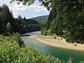
River (California), which flows into the Pacific Ocean near Eureka, United States South Fork Eel River, which flows into the Eel near Weott, California East...
1,007 bytes (169 words) - 00:42, 22 June 2021

Avenue of the Giants (redirect from California State Highway 254)
several small towns such as Phillipsville, Miranda, Myers Flat, Burlington, Weott, Englewood, Redcrest and Pepperwood. The two-lane road has a number of parking...
9 KB (1,050 words) - 05:18, 22 August 2023
Camp Mattole (category California in the American Civil War)
detachment of California Volunteer Mountaineers fighting the Bald Hills War, in early 1864. Camp Mattole was located 24 miles west of Weott, California in Humboldt...
1 KB (142 words) - 19:06, 28 March 2018
The following is a list of California locations by income. California had a per capita income of $29,906 during the five-year period comprising years 2010...
223 KB (903 words) - 21:38, 1 September 2023

Area codes 707 and 369 (category Area codes in California)
Pine Hills Redcrest Redway Rio Dell Samoa Scotia Shelter Cove Trinidad Weott Westhaven-Moonstone Willow Creek Whitethorn Clearlake Clearlake Oaks Clearlake...
13 KB (990 words) - 05:29, 12 July 2024

Humboldt Redwoods State Park (category State parks of California)
located 30 miles (48 km) south of Eureka, California, near Weott in southern Humboldt County, within Northern California, named after the great German nineteenth-century...
8 KB (888 words) - 15:27, 24 October 2023

States Numbered Highway, stretching from Los Angeles, California, to Tumwater, Washington. The California portion of US 101 is one of the last remaining and...
147 KB (7,210 words) - 02:53, 4 August 2024
unincorporated community in Humboldt County, California. It is located 15 miles (24 km) east-southeast of Weott, at an elevation of 1,594 feet (486 m). The...
3 KB (190 words) - 23:00, 2 January 2024
communities counties, and other recognized places in the U.S. state of California. Information on the number and names of counties in which the place lies...
32 KB (77 words) - 06:31, 6 March 2024

Phillipsville Pine Hills Redcrest Redway Samoa Scotia Shelter Cove Wautec Weitchpec Weott Westhaven-Moonstone Willow Creek Alton Bayside Blocksburg Briceland Bridgeville...
132 KB (7,686 words) - 08:28, 5 July 2024

unincorporated community in Humboldt County, California. It is located 12 miles (19 km) north-northeast of Weott, at an elevation of 636 feet (194 m). Bridgeville...
10 KB (939 words) - 02:04, 17 July 2024

joins from the west, near Humboldt Redwoods State Park and the town of Weott. Below the South Fork the Eel flows through a wider agricultural valley...
71 KB (8,372 words) - 03:45, 2 May 2024
Garberville Miranda Myers Flat Phillipsville Redcrest Redway Shelter Cove Weott Mendocino census-designated places Covelo Laytonville Leggett Humboldt unincorporated...
8 KB (766 words) - 08:28, 22 May 2024
The following is a list of California locations by race. According to 2010 data from the U.S. Census Bureau, people of White ancestry were the dominant...
236 KB (1,182 words) - 19:13, 9 July 2024
census-designated place in Humboldt County, California. It is located 4.5 miles (7.2 km) south-southeast of Weott, at an elevation of 203 feet (62 m). The...
9 KB (930 words) - 14:12, 29 November 2023

number of groves. Stops include Founders Grove, the Visitor Center near Weott and several locations that provide trail access. The area sees summers that...
23 KB (2,269 words) - 14:56, 14 May 2024
known as Weott Elementary) Casterlin Elementary School (K-8) Ettersburg School (K-3) Redway School (K-7) South Fork High School (Miranda, California) (8-12)...
8 KB (724 words) - 11:42, 7 April 2022
South Fork Eel River (redirect from Middleton Creek (California))
Fork, nearing its mouth, passes Burlington on the right bank, and Weott, California, also on the right bank. Several hundred yards upstream from its confluence...
29 KB (3,585 words) - 03:13, 13 May 2023
unincorporated community in Humboldt County, California. It is located 6 miles (10 kilometers) east-southeast of Weott, at an elevation of 1,004 feet (306 m)...
3 KB (191 words) - 05:32, 25 July 2023

County located on the South Fork Eel River 2 miles (3.2 km) northeast of Weott and 3 miles (4.8 km) east of Dyerville. It was originally settled by Northern...
8 KB (937 words) - 05:10, 23 July 2023
this redwood area. It was destroyed by the flood of 1955. USGS Map Name: Weott, CA; N40° 21' 19" W123° 55' 33 Hawk, Diane (2004). Touring the old redwood...
2 KB (195 words) - 04:22, 25 July 2022

census-designated place in Humboldt County, California. It is located 5.5 miles (8.9 km) north of Weott, at an elevation of 377 feet (115 m). The population...
7 KB (605 words) - 14:34, 29 June 2024
1860 Wiyot massacre (redirect from 1860 Weott massacre)
what is also known as Indian Island), near Eureka in Humboldt County, California. In coordinated attacks beginning at about 6 am, White settlers murdered...
17 KB (2,122 words) - 16:47, 3 May 2024

east), Garberville (11 miles east/southeast) Benbow, (12.2 miles ESE), Weott (13.3 miles NNE), Redcrest (18.3 miles N), Alderpoint (20.6 miles E). According...
10 KB (820 words) - 18:03, 1 August 2024

the National Register of Historic Places listings in Humboldt County, California. This is intended to be a complete list of the properties and districts...
22 KB (290 words) - 13:21, 15 July 2024

Christmas flood of 1964 (category Floods in California)
raging rivers. Riverside communities like Klamath, Orleans, Myers Flat, Weott, South Fork, Shively, Pepperwood, Stafford, and Ti-Bar were completely destroyed...
22 KB (2,134 words) - 22:10, 17 May 2024
1992 Cape Mendocino earthquakes (category Earthquakes in California)
unincorporated communities of Weott and Carlotta reported damage of less than $2 million combined. As the largest earthquake in California since the October 1989...
27 KB (3,247 words) - 19:19, 16 October 2023
measurement ‡: Another source states : no height †: 36.47 m in Claremont, California, United States, by another source 16.05 m by other sources Fanelli, from...
22 KB (612 words) - 17:19, 4 August 2024
List of South Fork Eel River crossings (category Lists of river crossings in California)
of California, rises near Laytonville and flows about 105 miles (169 km) in a northerly direction to its confluence with the Eel River near Weott. Some...
10 KB (326 words) - 06:11, 5 July 2023