
The Agefet is a river of the Nile basin. Rising in the mountains of Gheralta in northern Ethiopia, it flows westward to empty finally in the Weri’i which...
11 KB (948 words) - 08:05, 22 April 2024

550. Tributaries of the Wari include the Assam, Chemit, Meseuma, Tsedia, Agefet and Tsaliet rivers. The general drainage is westward, to the Tekezze River...
2 KB (200 words) - 08:02, 22 April 2024

Takkaze or Setit) Zarima River Ataba River Wari River Qortem Zer'a Tsaliet Agefet Ab'aro Azef River Amblo Korowya Ferrey River Kidane Mihret River May Meqa...
6 KB (572 words) - 06:20, 29 December 2022
/ 13.771118; 39.338038 Type Freshwater artificial lake Primary outflows Agefet Basin countries Ethiopia Surface area 0.135 km2 (0.052 sq mi) Water volume...
4 KB (330 words) - 14:23, 27 November 2023

Tributaries • left Graliwdo, May Meqa, Kidane Mihret, Ferrey • right Korowya, Agefet Waterbodies May Leiba reservoir, Kolu Ba’alti pond Waterfalls Tinsehe Bridges...
13 KB (1,234 words) - 19:29, 4 January 2024

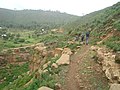
river to its mouth in Agefet, largely following the edge of the Azef gorge In the rainy season, flash floods may occur in Agefet and it is advised not...
10 KB (915 words) - 08:17, 22 April 2024
down from the Arebay peaks in Dogu'a Tembien towards the headwaters of Agefet river. From the higher to the lower locations, the following geological...
7 KB (595 words) - 06:28, 19 May 2024

Addi Amdey in Arebay municipality • elevation 2,460 m (8,070 ft) Mouth Agefet River • location Near Inda Gabir Amblo in Tsigereda municipality • coordinates...
10 KB (866 words) - 15:01, 4 January 2024

ridges towards the Agefet valley. The highest place is the cliff under Arebay (2,500 m.a.s.l.) and the lowest place along Agefet River (1,728 m.a.s.l...
14 KB (1,052 words) - 18:41, 12 November 2023

be confounded with the homonymous monastery) and the lowest place along Agefet River (1720 m a.s.l.). From the higher to the lower locations, the following...
22 KB (1,732 words) - 17:17, 3 December 2023

• location Atsa in Haddinnet municipality • elevation 2,340 m (7,680 ft) Mouth Agefet River • location NE of Addeha • coordinates 13°47′20″N 39°08′29″E / 13...
11 KB (986 words) - 08:17, 22 April 2024
metres (13°29′N 39°07′E / 13.483°N 39.117°E / 13.483; 39.117) Along Agefet River, north of Azef, 1720 metres (13°48′N 39°14′E / 13.800°N 39.233°E...
81 KB (10,139 words) - 15:51, 21 June 2024