
The county was formed in 1885; it was named for James W. Dawes, the Nebraska Governor at the time. In the Nebraska license-plate system, Dawes County is...
13 KB (992 words) - 23:39, 25 April 2024

Chadron (/ˈʃædrən/ SHAD-rən) is a city and the county seat of Dawes County, Nebraska, United States, in the Great Plains region. The population was 5...
23 KB (2,078 words) - 20:32, 9 July 2024

Thomas, Dawes, Blaine, and Sioux counties. The Nebraska National Forests & Grasslands began in 1902 as an experiment. University of Nebraska botany professor...
8 KB (729 words) - 22:09, 10 April 2024

Whitney is a village in Dawes County, Nebraska, United States. The population was 77 at the 2010 census. Originally called Dawes City, then Earth Lodge...
9 KB (818 words) - 22:00, 14 May 2024
Wales, Australia Dawes Arboretum, in Newark, Ohio, U.S. Dawes County, Nebraska, U.S. Dawes Township, Thurston County, Nebraska, U.S. Dawes (band), an American...
898 bytes (148 words) - 17:20, 30 April 2021

town of Belmont about halfway between Crawford and Marsland, Nebraska, in western Dawes County. It was built by the Chicago, Burlington and Quincy Railroad...
6 KB (597 words) - 22:50, 22 January 2022

Crawford is a city in Dawes County, Nebraska, United States, in the Great Plains region. The population was 997 at the 2010 census. It was incorporated...
20 KB (1,928 words) - 19:47, 16 August 2023

unincorporated community in southwestern Dawes County, Nebraska, United States. It lies on the Niobrara River along Nebraska Highways 2 and 71, 18 miles south...
8 KB (531 words) - 12:31, 18 July 2024

Fort Robinson (redirect from Fort Robinson, Nebraska)
managed by the Nebraska Game and Parks Commission, with some individual buildings operated by the History Nebraska and the University of Nebraska. In August...
15 KB (1,353 words) - 11:37, 23 July 2024
The Dawes County Courthouse in Chadron, Nebraska, United States, was built in 1935. It was designed in Art Deco style by John W. Latenser & Sons, Inc....
3 KB (199 words) - 04:48, 6 August 2023

Chadron State College (category Buildings and structures in Dawes County, Nebraska)
College (CSC) is a public college in Chadron, Nebraska. It is one of three public colleges in the Nebraska State College System. It practices open admissions...
10 KB (924 words) - 08:19, 19 June 2024
Pine Ridge is an unincorporated community in Dawes County, Nebraska, United States. A post office was established at Pine Ridge in 1911, and remained in...
1 KB (117 words) - 18:16, 14 November 2023
Chadron Municipal Airport (category Buildings and structures in Dawes County, Nebraska)
Chadron Municipal Airport (IATA: CDR, ICAO: KCDR, FAA LID: CDR) is in Dawes County, Nebraska, United States, five miles west of Chadron. It sees one airline...
13 KB (629 words) - 18:25, 5 December 2023

of Nebraska, it is a state highway that begins on the Wyoming–Nebraska state line west of Harrison near the Niobrara River and runs to the Nebraska–Iowa...
27 KB (2,027 words) - 07:04, 12 December 2023

Niobrara River (category Rivers of Dawes County, Nebraska)
the only major dam on the Niobrara River proper. Located in Dawes County in western Nebraska, the dam is part of the Mirage Flats Project, which irrigates...
17 KB (1,313 words) - 15:06, 28 March 2024

Belmont is a semi-ghost town in Dawes County, Nebraska, United States, approximately 11 miles (18 km) southeast of Crawford. Originally known as Evergreen...
8 KB (714 words) - 12:11, 18 July 2024

appointed Dawes as the first director of the Bureau of the Budget. Dawes served on the Allied Reparations Commission, where he helped formulate the Dawes Plan...
43 KB (4,518 words) - 10:21, 12 July 2024

Nebraska Highway 2 (N-2) is a state highway in Nebraska consisting of two discontinuous segments. The western segment begins at the South Dakota border...
21 KB (919 words) - 04:56, 6 July 2024

in Dawes County, Nebraska, United States. Horn was formerly called Remington. It was located on the Chicago, Burlington and Quincy Railroad. Nebraska portal...
1 KB (100 words) - 18:09, 14 November 2023
Nebraska may refer to: Whiteclay, Nebraska, known to the U.S. Census Bureau as "Pine Ridge, Nebraska" Pine Ridge (region) Pine Ridge, Dawes County, Nebraska...
201 bytes (61 words) - 18:53, 29 December 2019

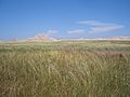
Toadstool Geologic Park (category Protected areas of Dawes County, Nebraska)
Geologic Park is located in the Oglala National Grassland in far northwestern Nebraska. It is operated by the United States Forest Service. It contains a badlands...
3 KB (220 words) - 02:48, 18 June 2024
Bordeaux is an unincorporated community in Dawes County, Nebraska, United States. Bordeaux took its name from Bordeaux Creek. A post office was established...
2 KB (115 words) - 20:18, 22 July 2023

US 385 Nebraska Highway 2 Nebraska Highway 71 Nebraska Highway 87 Dawes County - north Sheridan County - east Morrill County - south Scotts Bluff County -...
12 KB (911 words) - 13:18, 15 June 2024

between Sidney, Nebraska and the Black Hills to the north. Today, the highway enters Nebraska in the southeastern portion of the Nebraska Panhandle on the...
24 KB (2,434 words) - 14:50, 17 February 2024

Cowboy Trail (category Protected areas of Dawes County, Nebraska)
The Cowboy Trail is a rail trail in northern Nebraska. It is a multi-use recreational trail suitable for bicycling, walking and horseback riding. It occupies...
9 KB (716 words) - 05:06, 13 July 2024

Nebraska Highway 71 is a highway in western Nebraska. Its southern terminus is at the Colorado border south of Kimball, as a continuation of Colorado State...
7 KB (345 words) - 18:55, 21 September 2023

White River (Missouri River tributary) (redirect from White River (Nebraska))
River tributary that flows 580 miles (930 km) through the U.S. states of Nebraska and South Dakota. The name stems from the water's white-gray color, a function...
9 KB (505 words) - 23:32, 13 January 2024
Oglala National Grassland (category Protected areas of Dawes County, Nebraska)
National Grassland in the northwest corner of Nebraska. It is in northern Sioux and northwestern Dawes counties, on the borders with South Dakota and Wyoming...
4 KB (282 words) - 20:49, 30 May 2024

407 Pennington County - north Jackson County - northeast Bennett County - east Sheridan County, Nebraska - south Dawes County, Nebraska - southwest Fall...
20 KB (1,668 words) - 03:53, 10 June 2024

following is a list of the 93 counties in the U.S. state of Nebraska, listed by name, FIPS code and license plate prefix. Nebraska's postal abbreviation is NE...
26 KB (250 words) - 23:18, 25 April 2024