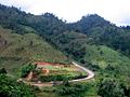
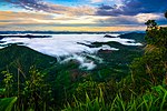
The Dawna Range (Burmese: ဒေါနတောင်တန်း; MLCTS: Dau:na. Taung:tan:; Thai: ทิวเขาถนนธงชัยตะวันตก, ทิวเขาดอยมอนกุจู), also known as Dawna Hills, is a mountain...
9 KB (764 words) - 17:10, 18 March 2024

Tenasserim Hills (redirect from Tanaosi Range)
latter is located beyond the northern end of the range, where the Tenasserim Hills meet the Dawna Range. Minor cross-border points are Sing Khon, near Prachuap...
23 KB (2,387 words) - 12:15, 14 May 2024

by the junta second-in-command Soe Win, began attempting to cross the Dawna Range to recapture the town in a counteroffensive known as "Operation Aung...
19 KB (1,591 words) - 15:42, 27 July 2024

While the land to the east is fairly flat, the Tenasserim Hills and Dawna Range lie to the west. Tak has a tropical savanna climate (Köppen climate classification...
9 KB (429 words) - 02:43, 29 February 2024

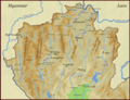
its south-eastern tip. The land area is 12,155 km2 (4,693 sq mi). The Dawna Range, running along the eastern side of the state in a NNW–SSE direction,...
23 KB (1,992 words) - 23:03, 22 July 2024
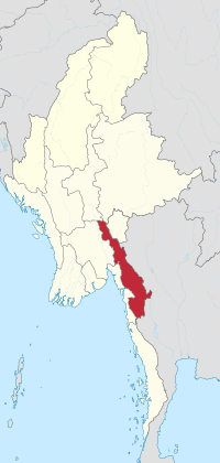
also spelled Pa-An. The terrain of the state is mountainous with the Dawna Range running along the state in a NNW–SSE direction and the southern end of...
26 KB (2,190 words) - 23:08, 22 July 2024

east of the province, while the west is mountainous which is part of Dawna Range and it covered with plentifully forest. Kamphaeng Phet known its natural...
17 KB (1,021 words) - 03:16, 13 April 2024

Thi Lo Su Waterfall (category Dawna Range)
The Thi Lo Su Waterfall (Thai: น้ำตกทีลอซู, RTGS: Namtok Thi Lo Su; S'gaw Karen: ထံလီၤဆူ, also spelt as Thee Lor Sue, The Lor Sue, Thee Lor Sue or Te-law-zue;...
2 KB (185 words) - 09:10, 28 December 2021

by the Burman population. Karen living in the eastern hills named the Dawna Range and the Tenasserim Hills bordering Thailand developed a distinct society...
65 KB (7,774 words) - 21:40, 2 August 2024

Huai Kha Khaeng Wildlife Sanctuary (category Dawna Range)
The Huai Kha Khaeng Wildlife Sanctuary (Thai: เขตรักษาพันธุ์สัตว์ป่าห้วยขาแข้ง, pronounced [kʰèːt rák.sǎː pʰān sàt pàː hûaj kʰǎː kʰɛ̂ŋ]) is in Uthai Thani...
9 KB (687 words) - 12:57, 1 August 2024
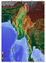
Range, which extends southwards forming the central range of the Malay Peninsula. The Dawna Range also stretches along the northern parts of the Tenasserim...
46 KB (3,406 words) - 00:03, 14 April 2024

of the Karen Armed Force's Eastern Division – seized control of the Dawna Range and much of the Thai border region and ordered KNUP cadres to leave his...
27 KB (2,834 words) - 15:11, 17 June 2024

second-in-command Soe Win. On 16 April, the LID 55 began attempting to cross the Dawna Range. The LID 55 was continually intercepted by the KNLA and allies, being...
376 KB (31,885 words) - 16:10, 4 August 2024

mountain ranges extend from the Daen Lao Range (ทิวเขาแดนลาว), in the southern region of the Shan Hills, in a north–south direction, the Dawna Range (ทิวเขาดอยมอนกุจู)...
24 KB (1,193 words) - 15:40, 19 July 2024

was established in 1984 in Tha Song Yang District, Tak Province in the Dawna Range area and houses 50,000 Karen refugees; the number continues to rise as...
8 KB (953 words) - 19:02, 17 July 2024

Daen Lao Range, in the northernmost portion of the province, marks the northern boundary between Thailand and Burma, while the Dawna Range in the west...
33 KB (2,973 words) - 06:45, 5 May 2024

mountain ranges extend from the Daen Lao Range (ทิวเขาแดนลาว), in the southern region of the Shan Hills, in a north-south direction, the Dawna Range (ทิวเขาดอยมอนกุจู)...
35 KB (3,436 words) - 01:54, 28 April 2024
Phu Toei National Park (category Dawna Range)
Phu Toei National Park (อุทยานแห่งชาติพุเตย) is a national park, with an area of 198,422 rai ~ 317 square kilometres (122 sq mi) in Dan Chang District...
5 KB (370 words) - 13:08, 25 November 2022

Thung Yai Naresuan Wildlife Sanctuary (category Dawna Range)
national border of Thailand with Burma, in the southern area of the Dawna Range. It extends northeast of the Three Pagodas Pass from Sangkhla Buri District...
33 KB (3,683 words) - 12:57, 1 August 2024

Khlong Lan National Park (category Dawna Range)
national park in Thailand. Khlong Lan National Park is situated in the Dawna Mountain Range. This park lies in Khlong Lan and Mueang Kamphaeng Phet districts...
5 KB (248 words) - 17:39, 11 July 2024

Myanmar. The relief of Karenni (Kayah) State is mountainous with the Dawna Range and the Karen Hills also known as "Karenni-Karen" mountains separated...
30 KB (2,845 words) - 10:44, 4 August 2024

Sites. On the western side of Tak province the Tenasserim Hills meet the Dawna Range. One of the few transnational roads and cross-border points into Myanmar...
23 KB (1,724 words) - 19:34, 3 August 2024

Umphang Wildlife Sanctuary (category Dawna Range)
Umphang Wildlife Sanctuary (Thai: เขตรักษาพันธุ์สัตว์ป่าอุ้มผาง) is a wildlife sanctuary in Thailand site in the Umphang District of Tak Province, northwestern...
6 KB (375 words) - 12:05, 29 June 2024

connected mountain ranges, including the Daen Lao Range, the Dawna Range, the Karen Hills, the Khun Tan Range, and the Thanon Thong Chai Range. The Kayah–Karen...
7 KB (559 words) - 21:28, 18 May 2024
Inthanon Range (ทิวเขาอินทนนท์). Often the Dawna Range further west and south is included as the western part of the Thanon Thong Chai Range. There are...
8 KB (712 words) - 14:04, 22 July 2024

leaving it and proceeding southwards overland through the Dawna Range and Bilauktaung Range (collectively these mountains form the Tenasserim Hills)....
12 KB (967 words) - 21:55, 1 April 2024

Mae Wong National Park (category Dawna Range)
(345 sq mi). Mae Wong National Park is in the Dawna Range. The park is rugged and hilly along the Dawna Mountain Range, especially on the north and west. With...
8 KB (625 words) - 09:44, 5 February 2024

of hornbill in the family Bucerotidae. It is found in forests of the Dawna Range and the Tenasserim Hills of southern Myanmar, adjacent parts of western...
2 KB (172 words) - 16:00, 21 December 2023
The Apprentice: Martha Stewart (redirect from Dawna Stone)
in celebration of Dawna's coronation. However, Martha refused to offer any alcoholic beverage to Dawna herself, since she wanted Dawna to celebrate her...
62 KB (7,261 words) - 15:18, 2 August 2024
Thai highlands (category Mountain ranges of Thailand)
the highest point in Thailand, reaching 2,565 metres (8,415 ft). The Dawna Range (ทิวเขาดอยมอนกุจู) forms the western border of Thailand between Mae Hong...
15 KB (1,427 words) - 17:53, 28 March 2024