
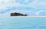
The Kermadec Islands (/ˈkɜːrmədɛk/ KUR-mə-dek; Māori: Rangitāhua) are a subtropical island arc in the South Pacific Ocean 800–1,000 km (500–620 mi) northeast...
29 KB (3,112 words) - 17:32, 29 July 2024
epicentres were located southeast of Raoul Island in the Kermadec Islands, part of the New Zealand outlying islands. The main magnitude 8.1 earthquake was...
16 KB (1,360 words) - 00:13, 21 May 2024

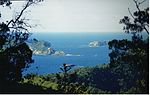
Raoul Island (Sunday Island; Māori: Rangitāhua) is the largest and northernmost of the main Kermadec Islands, 900 km (560 mi) south south-west of 'Ata...
34 KB (3,737 words) - 23:01, 24 July 2024
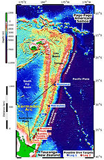
Kermadec Trench Fiji Lau Basin Tonga- Kermadec Ridge Lau- Colville Ridge Tonga Trench Osbourn Trough Louisville Seamount Chain Hikurangi Trough...
14 KB (1,192 words) - 04:27, 29 July 2024
The Tonga-Kermadec Ridge is an oceanic ridge in the south-west Pacific Ocean underlying the Tonga-Kermadec island arc. It is a result of the most linear...
12 KB (873 words) - 09:55, 13 August 2023

Island, Lord Howe Island, Norfolk Island, the Galápagos Islands, the Kermadec Islands, the Pitcairn Islands and the Torres Strait Islands currently have...
43 KB (4,275 words) - 13:55, 13 June 2024

List of earthquakes in New Zealand (redirect from 1986 Raoul Island earthquake)
"M 6.5 – Kermadec Islands, New Zealand". earthquake.usgs.gov. United States Geological Survey. Retrieved 7 July 2021. "M 6.6 – Kermadec Islands, New Zealand"...
65 KB (2,765 words) - 08:52, 21 August 2024
Lloyd, Ian E.M. Smith, and Simon Nathan. () New Zealand's volcanoes: Kermadec Islands Archived 2010-05-22 at the Wayback Machine. Volcanic Hazards Working...
19 KB (517 words) - 01:08, 27 May 2024

outlying islands are: The islands are all uninhabited except the Chatham Islands. There is a staffed meteorological station on Raoul Island of the Kermadec Islands...
12 KB (710 words) - 08:54, 11 July 2024

Islands Mariana Islands Tanimbar and Kai Islands Bismarck Archipelago Vanuatu Bougainville Island Solomon Islands Fiji Tonga Islands Kermadec Islands...
94 KB (9,604 words) - 01:21, 23 August 2024

Eastern Hemisphere; but Chatham Islands and Kermadec Islands, as well as the self-governing states of the Cook Islands and Niue and the dependent territory...
17 KB (1,155 words) - 17:35, 21 August 2024

The 2012 Kermadec Islands eruption was a major undersea volcanic eruption that was produced by the previously little-known Havre Seamount near the L'Esperance...
10 KB (917 words) - 16:19, 3 August 2024
the coast of Greece Žut and other islands off the coast of Croatia Kermadec Islands, part of New Zealand Korzhin Island in Lake Balkhash Klein Curaçao,...
19 KB (1,883 words) - 23:25, 1 June 2024
Polynesia (redirect from Polynesian islands)
Polynesians once inhabited the Auckland Islands, the Kermadec Islands, and Norfolk Island in pre-colonial times, but these islands were uninhabited by the time European...
95 KB (10,578 words) - 17:55, 17 August 2024

Geological Survey. August 11, 1969. Retrieved July 15, 2021. "M 8.0 - Kermadec Islands region". earthquake.usgs.gov. USGS. Retrieved 15 July 2021. Kanamori...
43 KB (1,793 words) - 11:08, 4 August 2024
Geological Survey. January 3, 2021. Retrieved January 3, 2021. "M 6.2 - Kermadec Islands Region, New Zealand". United States Geological Survey. January 5, 2021...
245 KB (11,348 words) - 04:04, 16 August 2024

a 7,500–10,000 square mile pumice raft that was discovered in the Kermadec Islands. Canterbury served as the primary logistical base for the NZDF Humanitarian...
27 KB (2,644 words) - 20:06, 3 July 2024
Nugent Island is the most northerly island in the Kermadec Islands and the most northerly part of New Zealand, being some 20 metres further to the North...
3 KB (215 words) - 11:06, 10 April 2024
National Earthquake Information Center (26 January 2023). "M 6.0 - Kermadec Islands, New Zealand". United States Geological Survey. Archived from the original...
323 KB (17,578 words) - 02:25, 7 July 2024

the Aleutian Island chain of US territory the Gilbert Islands and the Phoenix Islands of Kiribati North Island and the Kermadec Islands of New Zealand...
7 KB (391 words) - 18:13, 21 August 2024

Pacific Ocean from Lord Howe Island to the Juan Fernández Islands. Rarely is the Kermadec petrel recorded west of Lord Howe Island, where it maintains a small...
4 KB (476 words) - 02:54, 29 May 2024

Chatham Islands Chatham Island Forty-Fours Little Mangere Island Mangere Island Pitt Island The Sisters Rabbit Island Rangatira Island Star Keys Kermadec Islands...
30 KB (1,787 words) - 02:30, 21 June 2024

Oceania (section Pacific Islands)
Zealand's Antipodes Islands, Auckland Islands, Bounty Islands, Campbell Islands, Chatham Island and Kermadec Islands as being non-tropical islands of the South...
329 KB (29,174 words) - 13:05, 25 August 2024

New Zealand (category Island countries)
Kermadec Islands, about 1,000 km (620 mi) northeast of Auckland. Since 1937, the islands are uninhabited except for about six people at Raoul Island station...
267 KB (22,358 words) - 10:50, 26 August 2024
Kermadec or de Kermadec may refer to: Kermadec Islands, a subtropical island arc in the South Pacific Ocean northeast of New Zealand Kermadec Plate, a...
985 bytes (161 words) - 20:00, 31 May 2024
Geological Survey. "M7.4 – Kermadec Islands, New Zealand". Earthquake Hazards Program. U.S. Geological Survey. "M8.1 – Kermadec Islands, New Zealand". Earthquake...
79 KB (2,358 words) - 01:00, 23 August 2024

Tūī (category Birds of the Chatham Islands)
archipelago, ranging from the subtropical Kermadec Islands to the sub-Antarctic Auckland Islands, as well as the main islands. Europeans first encountered the...
26 KB (2,666 words) - 23:11, 6 August 2024

Polynesian settlements on Norfolk Island and the Kermadec Islands (Rangitahua). By the time the Europeans first arrived, these islands were all uninhabited. Today...
5 KB (552 words) - 01:35, 1 May 2024
ever recorded in the South Atlantic region, and is tied with the 2021 Kermadec Islands earthquake as the second largest earthquake of 2021. These earthquakes...
22 KB (1,852 words) - 17:45, 18 February 2024
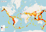
1954". Comprehensive Catalog. U.S. Geological Survey. ANSS. "M 7.5 – Kermadec Islands region 1955". Comprehensive Catalog. U.S. Geological Survey. ANSS....
111 KB (5,032 words) - 03:05, 27 August 2024