
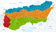
The Mieming(er) Range, Mieminger Chain (German: Mieminger Kette) or Mieminger Mountains (Mieminger Gebirge), is a mountain range of the Northern Limestone...
13 KB (1,681 words) - 03:49, 27 October 2024

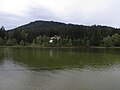
Mieming (German pronunciation: [ˈmiə̯mɪŋ] ) is a municipality in the Imst district and is located 19 km east of Imst and 6 km west of Telfs. Main sources...
3 KB (79 words) - 19:47, 20 August 2024
state of Tyrol at the southern foot of the Mieming Chain. It lies in the municipalities of Wildermieming, Mieming, Obsteig and Mötz. The low mountain terrace...
2 KB (285 words) - 01:38, 4 November 2024
Northern Limestone Alps (category Mountain ranges of the Alps)
Nördliche Kalkalpen), also called the Northern Calcareous Alps, are the ranges of the Eastern Alps north of the Central Eastern Alps located in Austria...
4 KB (227 words) - 21:16, 3 November 2024

Ötztal Alps (category Mountain ranges of the Alps)
The Ötztal Alps are surrounded by the following ranges: Lechtal Alps Mieming Range Stubai Alps Sarntal Alps Ortler Alps Sesvenna Alps Samnaun Alps In September...
6 KB (268 words) - 19:37, 3 November 2024
Imst (category Mieming Range)
Imst (German: [ɪmst] ; Southern Bavarian: Imscht) is a town in the Austrian federal state of Tyrol. It lies on the River Inn in western Tyrol, some 50...
11 KB (478 words) - 17:18, 4 November 2024

Wetterstein (category Mountain ranges of the Alps)
Alps, the Wetterstein and the Mieming range are classed as a single group. The River Loisach forms the boundary of the range to the west and north, from...
14 KB (1,398 words) - 09:43, 1 November 2024

244 ft)) is a summit of the Mieming Range in the Austrian state of Tyrol. It separates the Griessspitzen to the north from the Mieming Plateau to the south....
978 bytes (36 words) - 16:25, 14 July 2024

Wildmoossee (category Mieming Range)
The Wildmoossee is an aperiodic mountain lake, 3 kilometres west of Seefeld in Tirol near the village of Wildmoos in the market borough of Telfs. The lake...
2 KB (181 words) - 16:09, 14 July 2024

Stubai Alps (category Mountain ranges of the Alps)
station) to the confluence with the Gurglbach (near Imst), then to the Mieming Chain (AVE 4) in the Northern Limestone Alps in the north, it follows the...
8 KB (775 words) - 13:38, 12 November 2024
Roppen (category Mieming Range)
Roppen is a municipality in the Imst district and is located 5 km southeast of Imst between the mouths of the Pitze River and the Ötztaler Ache. The village...
3 KB (93 words) - 01:26, 8 November 2021

Biberwier (category Mieming Range)
Biberwier is a municipality with 612 inhabitants (as of 1 January 2019) in the district of Reutte in the Austrian state of Tyrol. The municipality is located...
6 KB (434 words) - 07:55, 31 August 2022
Wildmoos (Telfs) (category Mieming Range)
Wildmoos is an area in the central Inn valley in North Tyrol and a village in the municipality of Telfs in the district of Innsbruck Land. Wildmoos lies...
4 KB (199 words) - 19:31, 19 May 2021

Seefeld in Tirol (category Mieming Range)
Mösern) is surrounded by the Wetterstein mountain range to the west, and the Karwendel mountain range to the east; it falls away in a steep drop off to...
33 KB (2,342 words) - 06:27, 30 July 2024

Nassereith (category Mieming Range)
Nassereith is a municipality and a village in the Imst district in Tyrol, Austria and is located 11 km north of Imst on the upper course of the Gurgl brook...
4 KB (130 words) - 03:13, 4 March 2024

Tarrenz (category Mieming Range)
Tarrenz is a municipality in the Imst district and is located 3.60 km north of Imst at the lower course of the Gurgl brook. The village is an agriculture...
4 KB (136 words) - 16:16, 20 June 2022
Wannig (category Mieming Range)
493-metre-high mountain in the Mieming Chain in the Austrian state of Tyrol. The Wannig forms the western end of the Mieming Range. To the southwest lies the...
4 KB (318 words) - 16:25, 14 July 2024

Telfs (category Mieming Range)
Telfs Telfs seen from the Mieming Range Flag Coat of arms Location of Telfs in Tyrol Telfs Location within Austria Coordinates: 47°17′00″N 11°04′00″E...
4 KB (117 words) - 14:43, 16 October 2023

Karrösten (category Mieming Range)
Karrösten is a municipality and a village in the district of Imst, located 1.3 km east of Imst. The village was founded because of mining in the 16th century...
3 KB (87 words) - 15:51, 1 November 2023

Seefeld Plateau (category Mieming Range)
Limestone Alps between the Wetterstein Mountains to the northwest, the Mieming Mountains to the west and the Karwendel to the east. The Seefeld Saddle...
5 KB (478 words) - 13:21, 4 November 2024

upper range Gaistalbach) is a river of Tyrol, Austria and of Bavaria, Germany, a left tributary of the Isar. The Leutascher Ache springs in the Mieming Range...
2 KB (149 words) - 16:29, 14 July 2024

Hohe Munde (category Mieming Range)
Munde is a 2,662-metre-high (8,734 ft) mountain at the eastern end of the Mieming Chain in the Austrian state of Tyrol. It has two peaks: the west top (2...
5 KB (377 words) - 16:20, 14 July 2024

Seebensee (category Mieming Range)
rock basin lake) at a height of 1,657 metres, south of Ehrwald in the Mieming Range. It is surrounded by the Vorderer Tajakopf in the east, the Vorderer...
4 KB (412 words) - 16:09, 14 July 2024

Fern Pass (category Mieming Range)
in Austria. It is located between the Lechtal Alps on the west and the Mieming Mountains on the east. The highest peak in Germany, the Zugspitze is only...
4 KB (418 words) - 16:11, 14 July 2024

Hochplattig (category Mieming Range)
Mieming Chain, a mountain range in the Northern Limestone Alps in the state of Tyrol, Austria. The Hochplattig lies on the main crest of the Mieming Chain...
5 KB (495 words) - 16:18, 14 July 2024

Hochwand (2,719 m) is a mountain in the Mieming Range of Tyrol, Austria. It is most famous for its impressive north face, which tumbles for 1,300 m down...
2 KB (96 words) - 12:27, 16 August 2024
Hut Swiss Alpine Club Pennine Alps Coburger Hütte German Alpine Club Mieming Range Cosmiques Hut Compagnie des Guides de Chamonix commune de Chamonix-Mont-Blanc...
27 KB (111 words) - 18:30, 23 October 2024

Wildermieming (category Mieming Range)
west of Innsbruck and 4 km west of Telfs. The village was separated from Mieming which belongs to Imst (district) in 1833 and was incorporated into Innsbruck-Land...
3 KB (94 words) - 02:46, 3 April 2020

Vorderer Tajakopf (category Mieming Range)
The Vorderer Tajakopf is a 2,450-metre-high mountain in the Mieming Chain in the Austrian state of Tyrol. The normal route to the summit runs from the...
3 KB (138 words) - 01:24, 16 January 2024
17889 Geography Gschwandtkopf near Seefeld; Innsbruck Land, Tyrol (Austria) Parent range Mieming Range Climbing Normal route gravelled track from Mösern...
3 KB (302 words) - 16:17, 14 July 2024