Montauk Highway is an east–west road extending for 95 miles (153 km) across the southern shore of Long Island in Suffolk County, New York, in the United...
32 KB (2,461 words) - 01:15, 17 November 2024
New York State Route 27 (redirect from Montauk Point State Parkway)
(194.05 km) long state highway that runs east–west from Interstate 278 (I-278) in the New York City borough of Brooklyn to Montauk Point State Park on Long...
52 KB (4,099 words) - 01:15, 17 November 2024
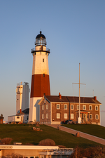
tip of Long Island, at 2000 Montauk Highway, is a privately run museum, and is not part of Montauk Point State Park. Montauk Light was the first lighthouse...
17 KB (1,805 words) - 18:09, 29 September 2024
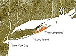
colonies of the northeastern United States. The Montauk Branch of the Long Island Rail Road, the Montauk Highway, and private bus services connect the Hamptons...
27 KB (2,507 words) - 05:38, 19 November 2024
List of county routes in Suffolk County, New York (26–50C) (redirect from Corporal Tony Casamento Highway)
intersections The entire route is located in Montauk. County Route 31 is a short north-south county highway running across rural eastern Suffolk County...
71 KB (5,963 words) - 07:11, 10 November 2024
and CR 94 in Riverside. Route description The road begins at CR 80 (Montauk Highway) just east of the eastern terminus of CR 98 (Frowein Road). The route...
67 KB (5,327 words) - 07:31, 20 November 2024
New York State Route 27A (redirect from New York State Highway 27A)
components are Merrick Road and Montauk Highway. NY 27A begins at a large junction between NY 27 (the Sunrise Highway) in front of the former Sunrise...
23 KB (2,462 words) - 01:15, 17 November 2024
line between Nassau and Suffolk into Amityville, where it becomes Montauk Highway at the Amityville–Copiague village/hamlet line. The easternmost portion...
13 KB (868 words) - 19:57, 7 November 2024
southern side of Montauk Highway the water reached up to 6 feet (1.8 m) high. When multiple fires broke out south of Montauk Highway, firefighters were...
16 KB (1,627 words) - 22:09, 16 November 2024
service, and ferry service. The most prominent road on the south fork is Montauk Highway (part of New York State Route 27) which traverses the entire region...
5 KB (626 words) - 09:50, 11 October 2023
end on the Montauk Branch of the LIRR, resuming its trajectory between Montauk Highway and the eastbound service road of Sunrise Highway at Exit 56....
17 KB (1,753 words) - 22:19, 15 May 2024
in size, running from Montauk Highway north to Block Island Sound and is bordered on the east by Montauk Point State Park. Montauk County Park was created...
10 KB (1,141 words) - 15:20, 20 June 2024
The Montauk Branch is a rail line owned and operated by the Long Island Rail Road in the U.S. state of New York. The line runs the length of Long Island...
36 KB (2,457 words) - 22:57, 2 September 2024
eleven in the immediate area. The area where Main Street, also known as Montauk Highway, is located today, was the approximate area of the original hamlet...
16 KB (1,484 words) - 16:03, 4 November 2024
miles (2.45 km) through the town of Babylon. It begins at NY 27A (Montauk Highway) in Amityville and heads north to the intersection of Joyce Avenue...
85 KB (6,807 words) - 05:27, 9 November 2024
kindergarten through eighth grade. The Greene House is located at 93 Montauk Highway. George Washington stopped at this historic house during a tour of...
13 KB (1,222 words) - 20:51, 4 February 2024
railroad, and its earlier status as a way station on Montauk Highway, originally the only through highway on Long Island's south shore, most of the core of...
34 KB (4,241 words) - 23:06, 21 November 2024
census-designated place (CDP) of Copiague. It is located south of Merrick Road (or Montauk Highway), off of South Great Neck Road in Suffolk County, New York, USA, on...
7 KB (286 words) - 22:24, 24 July 2024
is Sunrise Highway, the other limited-access highway in the town that does not forbid trucks. New York State Route 27A is Montauk Highway west of Connetquot...
31 KB (3,039 words) - 10:53, 17 August 2024
South Country Road (now Montauk Highway). Higbie Lane starts as a two lane divided highway with a U-turn at NY 27A (Montauk Highway), between the historic...
63 KB (6,125 words) - 16:06, 25 July 2024
Highway (CR 80), a two-lane road which runs from New York City to Montauk. Montauk Highway serves as the "Main Street" of many towns and villages along the...
14 KB (1,108 words) - 23:11, 6 November 2024
"East Main Street" in the western portion of East Patchogue, and "Montauk Highway" (as it typically is outside of villages) in the eastern portion. The...
13 KB (1,204 words) - 20:46, 20 November 2024
the Brightwaters Canal directly south of Montauk Highway, and four lakes directly north of Montauk Highway: Cascades Lake, Mirror Lake, Lagoon Lake and...
13 KB (1,019 words) - 18:15, 18 October 2024
Montauk Point State Park is a 862-acre (3.49 km2) state park located in the hamlet of Montauk, at the eastern tip of Long Island in the Town of East Hampton...
6 KB (450 words) - 21:03, 3 September 2024
1840s the Youngs family lived about one and a half miles south of Montauk Highway on Great River Road. Erastus Youngs and his family began building and...
41 KB (5,112 words) - 02:07, 22 November 2024
2000 a second retail location was opened for seasonal business at 354 Montauk Highway, Wainscott, in the Hamptons area of eastern Long Island. A third store...
7 KB (562 words) - 21:01, 21 June 2024
Suffolk County Transit also provides bus service in Sayville via Montauk Highway. The Sayville School District consists of one high school, one middle...
21 KB (2,130 words) - 02:48, 21 November 2024
crop losses. Storm surge flooded LaGuardia Airport and inundated the Montauk Highway, which left the eastern portion of Long Island isolated. Carol also...
41 KB (4,167 words) - 21:29, 10 October 2024
The Oakdale Merge is a convergence of Sunrise Highway (New York State Route 27, NY 27) and Montauk Highway (NY 27A and County Route 85, CR 85) between the...
12 KB (1,207 words) - 22:28, 2 September 2024
ocean ("south of the Montauk Highway"), much simpler houses and bungalows have been built in such areas as Springs and Montauk. In the 1950s and 1960s...
83 KB (9,810 words) - 22:45, 15 November 2024


