
Mount Lindesay Highway is an Australian national highway located in Queensland. The highway runs southwest from Brisbane, where it leaves Ipswich Road...
26 KB (1,537 words) - 06:49, 13 August 2024

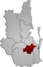
coordinates) Mount Lindesay is a rural locality in the Scenic Rim Region, Queensland, Australia. It borders New South Wales. In the 2021 census, Mount Lindesay had...
16 KB (1,533 words) - 05:19, 28 May 2024

Summerland Way (category Highways in Australia)
border with Queensland just west of Mount Lindesay, and continues from there into Queensland as Mount Lindesay Highway. It was named as the region in runs...
24 KB (2,104 words) - 12:38, 18 August 2024
Mount Lindesay Highway state-controlled roads presents information about how the Mount Lindesay Highway is described for administrative and funding purposes...
6 KB (496 words) - 02:20, 5 March 2024
north-east, the Logan Motorway joins the Pacific Motorway, while the Mount Lindesay Highway and Sydney–Brisbane rail corridor cross the city along a roughly...
46 KB (3,922 words) - 20:41, 7 October 2024

Rathdowney had a population of 320 people. Rathdowney is on the Mount Lindesay Highway 32 kilometres (20 mi) south of Beaudesert at the base of the McPherson...
19 KB (1,736 words) - 07:58, 15 June 2024
Lions Road (category Highways in Australia)
road running between the Summerland Way in New South Wales and the Mount Lindesay Highway near Rathdowney, Queensland at Running Creek. It joins two pre-existing...
3 KB (424 words) - 10:12, 18 December 2021
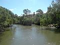
Gondwana Rainforests of Australia. The river is crossed by the Mount Lindesay Highway near Rathdowney and at North Maclean via Maclean's Bridge. The river...
20 KB (1,810 words) - 00:19, 1 April 2024

mountain was later given another name, Mount Barney. He also originally named the current Mount Lindesay, Mount Hooker. On 9 October Logan set out to explore...
17 KB (1,737 words) - 08:08, 6 October 2024

New England Highway through Beaudesert was renamed Mount Lindesay Highway, and the New South Wales section was re-declared as State Highway 24 (this was...
41 KB (2,871 words) - 00:51, 9 September 2024
section 10E: Dawson Highway Gladstone–Mount Larcom Road Bajool–Port Alma Road Gavial–Gracemere Road Burnett Highway Capricorn Highway Rockhampton–Yeppoon...
40 KB (3,168 words) - 15:45, 4 April 2024

stage of the Ross River Dam necessitated a deviation of the Flinders Highway and Mount Isa railway line (which previously ran straight north-south) to be...
19 KB (1,267 words) - 00:30, 5 May 2024
Road Mount Lindesay Highway Brisbane Valley Highway D'Aguilar Highway Palmerston Highway Burke Developmental Road Mulligan Highway Cunningham Highway Captain...
5 KB (381 words) - 02:22, 30 July 2024
Freeways in Australia (category Highways in Australia)
roads Moreton Bay Road (Freeway grade from Chandler to Capalaba) Mount Lindesay Highway (Freeway grade from Drewvale to North MacLean – see full route here...
31 KB (2,594 words) - 06:55, 7 October 2024

Cairns. The highway passes the Glasshouse Mountains, rainforests and pastures in the Sunshine Coast, the Gunalda Range (north of Gympie), Mount Larcom (north...
103 KB (5,373 words) - 07:55, 6 August 2024
maps. In addition to the Bruce Highway, the Captain Cook Highway, Cairns Western Arterial Road, and the Kennedy Highway, the network consists of the following...
6 KB (503 words) - 21:15, 5 April 2024

Logan Motorway (category Highways in Queensland)
lanes in each direction between Wembley Road and Beaudesert Road / Mount Lindesay Highway relocating the Logan Motorway on and off-ramps at Wembley Road new...
16 KB (1,058 words) - 13:05, 21 July 2024

Ipswich Motorway. Logan Road, Pacific Motorway, and Beaudesert Road (Mount Lindesay Highway) are the other major roads in the south of Brisbane. Ipswich Road...
11 KB (856 words) - 12:28, 15 July 2024
Ferry Road River Road (Queensland) Mount Crosby Road Ipswich–Warrego Highway Connection Road Brisbane Valley Highway Haigslea–Amberley Road Rosewood–Marburg...
23 KB (1,837 words) - 00:40, 22 January 2024
The present highway network in New South Wales, Australia was established in August 1928 when the Main Roads Board (the predecessor of the Department...
9 KB (366 words) - 05:39, 12 August 2024

the then Governor of Victoria. The highway runs between Cloncurry via Mount Isa and Camooweal to the Stuart Highway north of Tennant Creek, at the junction...
13 KB (829 words) - 12:40, 24 June 2024

Brisbane Valley Highway is a state highway in Queensland, Australia. It links the Warrego Highway near Ipswich and the D'Aguilar Highway about 4 km (2 mi)...
13 KB (759 words) - 12:20, 15 July 2024

The Balonne Highway, a state highway of Queensland, is the continuation westward of State Route 49 (Moonie Highway) from the town of St George to its termination...
7 KB (344 words) - 10:44, 20 December 2023
as a highway, but without a highway name. For example, Great Southern Highway is classified as a main road, not as a highway, or Hereward Highway in the...
24 KB (399 words) - 08:34, 6 June 2024

Brisbane and west of the Gold Coast. Beaudesert is located on the Mount Lindesay Highway, some 70 kilometres (43 mi) south of Brisbane. The area sources...
50 KB (4,626 words) - 00:34, 27 September 2024

Highway 1 along either coast. Roads that make up the highway are: Great Central Road Gunbarrel Highway Lasseter Highway Stuart Highway Plenty Highway...
9 KB (310 words) - 05:03, 11 February 2024
road of regional significance (LRRS). It runs from the Cunningham Highway in Mount Edwards, via Moogerah, to Boonah–Fassifern Road in Fassifern Valley...
22 KB (1,702 words) - 22:38, 9 February 2024

with the Bruce Highway in Marlborough. It runs southwest and west as Marlborough Road through the localities of Marlborough and Mount Gardiner, where...
20 KB (1,472 words) - 13:06, 6 October 2024

endpoint of the highway. The entire highway is part of the National Highway system linking Darwin and Brisbane: formerly National Highway 54, Queensland...
30 KB (2,105 words) - 12:42, 9 March 2024

had a population of 7,423 people. Jimboomba is situated on the Mount Lindesay Highway, 29.6 kilometres (18.4 mi) by road south-east of Logan Central and...
20 KB (1,960 words) - 04:19, 17 June 2024