
Olancha (Timbisha: Pakwa' si) is a census designated place in Inyo County of the U.S. state of California. Olancha is located on U.S. Route 395 in California...
13 KB (1,500 words) - 21:40, 28 August 2024

Crystal Geyser Water Company (category 1977 establishments in California)
an aquifer to the east of Mount Whitney with its plant located at Olancha, California, where it bottles, sells and exports water for Japanese domestic...
7 KB (634 words) - 08:22, 27 March 2024
dunes and the exterior of the roadside diner was carried out at Olancha, California in the Owens Valley, located on U.S. Route 395, approximately 300 km...
7 KB (909 words) - 14:42, 29 September 2024

Coso artifact (category 1961 in California)
Mikesell while they were prospecting for geodes near the town of Olancha, California, it has long been claimed as an example of an out-of-place artifact...
6 KB (707 words) - 11:43, 10 July 2024
discovered a metal artifact encased in hard clay near the town of Olancha, California. The artifact was dubbed "Coso artifact" due to alleged claims that...
6 KB (571 words) - 18:42, 28 April 2023

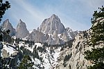
Olancha Peak is a mountain in the Sierra Nevada of California. It rises to an elevation of 12,132 feet (3,698 m) on the Tulare-Inyo county line in the...
3 KB (247 words) - 20:05, 7 July 2023

in the Sequoia National Forest. The eastern portion begins at US 395 at Olancha, heads east through Death Valley National Park, and ends at State Route...
24 KB (2,820 words) - 06:13, 22 August 2023
Tremors (1990 film) (category Films shot in California)
Perfection, Nevada. The town, which was entirely a set, was built near Olancha, California. The mountains in the distance are the Sierra Nevada, and Owens Lake...
30 KB (3,452 words) - 18:12, 21 September 2024

Adamson Landing Field (category Airports in Inyo County, California)
Landing Field is a closed airport located 1.8 mi south-southeast of Olancha, California. During World War II, the airport was used by the United States Army...
2 KB (88 words) - 08:00, 10 February 2024
Bug (2006 film) (category Films shot in California)
there, including the crew. Exteriors of the motel were filmed near Olancha, California, and at Grace King High School in Metairie, Louisiana, while studio...
24 KB (2,588 words) - 07:36, 25 September 2024

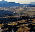
what is commonly called the California Water Wars. Along the shores of Owens Lake, the highway passes by Cartago and Olancha. Just north of the lake is...
56 KB (4,686 words) - 08:00, 15 September 2024
Retrieved 8 June 2016. "OLANCHA". Datasheet for NGS Station GT1820. U.S. National Geodetic Survey. Retrieved 8 June 2016. "Olancha Peak". Geographic Names...
54 KB (5,512 words) - 01:44, 3 September 2024
Eastern Sierra (redirect from California Eastern Sierra)
Bridgeport, Lee Vining, Bishop, Big Pine, Independence, Lone Pine, and Olancha, with Bishop being the largest city in the area. It is sparsely populated...
2 KB (154 words) - 23:07, 30 June 2023
Timbisha (redirect from Death Valley Timbisha Shoshone Band of California)
as Kooso or Muattan(g Ka)) Pakkwasitsi (″People of Pakkwasi, i.e. Olancha, California area″, just south of Owens Lake) Saline Valley Band / Ko'ongkatün...
32 KB (3,748 words) - 18:52, 29 September 2024

Creek and Clearlake), is the only incorporated city in Calaveras County, California, United States. The population was 3,836 at the 2010 census, up from 3...
15 KB (1,473 words) - 04:11, 19 August 2024
Tennessee. 1961 – An allegedly 500,000-year-old rock is discovered near Olancha, California, US, that appears to anachronistically encase a spark plug. 1967...
50 KB (5,105 words) - 16:52, 29 September 2024

Area codes 760 and 442 (category Area codes in California)
Laws Lone Pine Mesa Olancha Panamint Springs Pearsonville Round Valley Shoshone Tecopa West Bishop Wilkerson Bodfish Boron California City Cantil China...
11 KB (594 words) - 05:36, 12 July 2024

Owens Lake (category Endorheic lakes of California)
1920s. The town of Cartago, below the Sierra Nevada near present-day Olancha, California, was the western shipping port for the Cerro Gordo Mines production...
29 KB (2,819 words) - 19:01, 4 September 2024

in Inyo County, California, United States. Cartago is located on the west side of Owens Lake 3 miles (4.8 km) north-northwest of Olancha. The population...
9 KB (971 words) - 05:21, 24 August 2024
The following is a list of California locations by income. California had a per capita income of $29,906 during the five-year period comprising years 2010...
223 KB (903 words) - 21:38, 1 September 2023

(formerly Fresno Flats) is a census-designated place (CDP) in Madera County, California, United States, 14 miles (23 km) south of the entrance to Yosemite National...
30 KB (2,967 words) - 15:58, 18 August 2024
subsequently lost in the deserts of the American Southwest, most commonly in California's Colorado Desert. Since the period following the American Civil War, stories...
33 KB (1,489 words) - 21:44, 7 September 2024
The following is a list of California locations by race. According to 2010 data from the U.S. Census Bureau, people of White ancestry were the dominant...
236 KB (1,182 words) - 19:13, 9 July 2024
(69.2 km) from Quaking Aspen in the Sequoia National Forest to US 395 at Olancha. On June 25, 1982, deleting the unconstructed section was recommended,...
47 KB (5,449 words) - 03:19, 29 December 2023

Golden Trout Wilderness (category Wilderness areas of California)
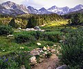
upper Kern River drainage and much of the far southern Sierra, including Olancha Peak, the southern Kaweah Range, the mountains of the Mineral King area...
10 KB (1,068 words) - 04:46, 12 June 2024

unincorporated community and census-designated place (CDP) in Mono County, California, United States. It is the Mono county seat. The population was 553 at...
18 KB (1,417 words) - 03:25, 29 August 2024

census-designated place (CDP) in the southern Sierra Nevada, in Kern County, California, United States. Kernville is located 42 miles (68 km) northeast of Bakersfield...
15 KB (1,214 words) - 05:59, 28 July 2024
Kawaiisu: Tihachipia, meaning "hard climb") is a city in Kern County, California, United States, in the Tehachapi Mountains, at an elevation of 3,970 feet...
43 KB (4,104 words) - 13:20, 26 September 2024

Truckee is an incorporated town in Nevada County, California, United States. As of the 2010 United States Census, the population was 16,180, reflecting...
40 KB (4,145 words) - 21:48, 28 September 2024

Quinsy) is a census-designated place and the county seat of Plumas County, California. The population was 1,630 during the 2020 Census, down from 1,728 during...
21 KB (1,632 words) - 21:41, 6 September 2024